الأثر المدمر للزلازل المتعاقبة ذات الشدة العالية التي وقعت في كهرمان مرعش بتركيا في 6 فبراير 2023 Destructive impact of successive high magnitude earthquakes occurred in Türkiye’s Kahramanmaraş on February 6, 2023
زلزاليْن متعاقبيْن بقيم لحظية قدرها (عمق البؤرة = 8.6 كم) و (عمق البؤرة = 7 كم) حدث تقريبًا خلال 9 ساعات في 6 فبراير 2023، في تركيا، على التوالي. كانت مراكز الزلزال في منطقتي بازرجيك وإلبستان في كهرمان مرعش. حدثت الزلزالان في منطقة صدع الأناضول الشرقي، وهي واحدة من نظامي الصدع النشطين الرئيسيين في تركيا. بين هذين الزلزالين الشديدين، كان هناك هزة ارتدادية كبيرة أخرى بقوة لحظة قدرها 6.6، وكان مركزها في منطقة نورداجي في غازي عنتاب. ثم، في 20 فبراير 2023، حدث زلزال ارتدادي آخر بقوة وقعت في منطقة يايلا داغي في هاتاي. نتيجة للزلازل، حدثت أضرار جسيمة في عدة محافظات ومناطق يبلغ عدد سكانها حوالي 15 مليون نسمة، وقد فقد أكثر من 50,000 شخص حياتهم. تقدم هذه الدراسة تحقيقات جيوتقنية وهيكلية في الموقع من قبل فريق من الباحثين بعد زلازل كهرمان مرعش. تلخص أداء بيئات المباني نتيجة للتقييمات الميدانية، مع الأخذ في الاعتبار الأضرار الهيكلية الملحوظة، وظروف الموقع المحلية، وبيانات الحركة الأرضية القوية. يتم تناول الأسباب المحتملة للأضرار الملحوظة بالتفصيل. كشفت هذه الزلازل مرة أخرى عن العيوب الشائعة للهياكل الخرسانية المسلحة القائمة في تركيا، مثل ضعف جودة المواد، وسوء التنفيذ، وعدم ملاءمة تفاصيل التسليح، وتقنيات البناء غير الكافية المقاومة للزلازل. كما تضررت الهياكل الخرسانية مسبقة الصنع والمباني في المنطقة بشدة خلال الزلازل بسبب نقص الخدمات الهندسية، وضعف المواد، والعيوب أثناء البناء، وغيرها.
الكلمات الرئيسية استكشاف الزلازلأضرار الزلزالزلازل كهرمان مرعشالهياكل الخرسانية المسلحةالهياكل الخرسانية مسبقة الصبالهياكل الحجرية
1 المقدمة
تقع تركيا والمناطق المحيطة بها، التي تتعرض لعمليات تكتونية ضاغطة تحت تأثير الصفائح الأوراسية والعربية والأفريقية، على الصفيحة الأناضولية النشطة زلزالياً، حيث وقعت زلازل كبيرة على مر التاريخ (ماكنزي 1972؛ شينغور وييلماز 1981). تعتبر مناطق الفوالق الأكثر أهمية في منطقة الأناضول هي منطقة فالق شمال الأناضول (NAFZ) ومنطقة فالق شرق الأناضول (EAFZ)، التي تظهر خصائص الانزلاق الجانبي. تتسبب هذه الفوالق في حركة الصفيحة الأناضولية نحو الغرب في اتجاه عكس عقارب الساعة، ونتيجة لهذا النشاط، وقعت زلازل مدمرة في الأناضول ومحيطها المباشر (باركا وكادينسكي-كاد 1988؛ دوما وإيمري 2013). على الرغم من أن NAFZ، التي يبلغ طولها حوالي 1500 كم، تتميز بخصائص انزلاق جانبي يميني، فإن EAFZ، التي يبلغ طولها حوالي 550 كم، تتميز بانزلاق جانبي يساري (الشكل 1) (شينغور وآخرون 1985؛ باركا وريلينجر 1997).
من عام 1900 حتى الآن، حدثت 20 زلزالًا بقوة زلزالية (moment magnitude) أكبر من 7.0 قد حدثت في تركيا. بالإضافة إلى ذلك، حدثت 269 زلزالًا آخر بمقاييس مختلفة بين عامي 1900 و2023، مما تسبب في أضرار ووقوع إصابات. من بين هذه الزلازل، كان الأهم زلزال إرزينجان عام 1939.1944 جيريد1999 كوجالي ( ) ودوزجة ( )، 2011 فورد ( 2023 كهرمان مرعش و ) الزلازل (ITU 2023). من بينها، تعتبر الزلازل الأكثر شدة من حيث الضحايا والأضرار الكبيرة هي زلزال إرزينجان عام 1939، وزلزال كوجالي مركزه غولجوك عام 1999، وزلزال كهرمان مرعش عام 2023، على التوالي.
وفقًا لسجلات رئاسة الكوارث والطوارئ في تركيا (AFAD)، في 6 فبراير 2023، حدث زلزان بقوة (عمق البؤرة = 8.6 كم) و حدثت (عمق البؤرة = 7 كم) في الساعة 04:17 (بتوقيت غرينتش +3) وبعد حوالي 9 ساعات في الساعة 13:24، على التوالي. كانت مراكز الزلزال في منطقتي بازرجيك وإلبستان في كهرمان مرعش. حدث الزلزالان على خط الصدع النشط الشرقي، وهو أحد نظامي الصدع النشطين الرئيسيين في تركيا.
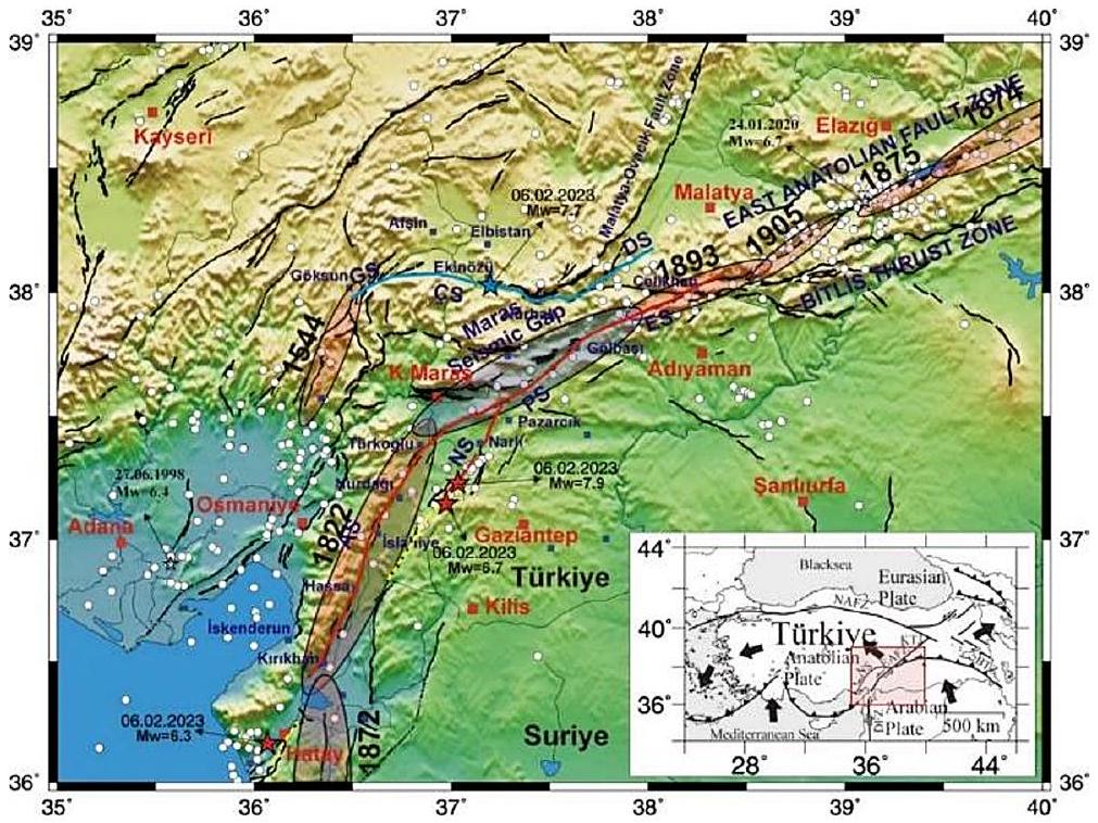
الشكل 1 التكوين التكتوني العام لتركيا (الإطار) وميزات الزلازل التكتونية لمنطقة الصدع الشرقي الأفريقي
نتيجة للزلازل، تعرضت المحافظات والمناطق في كهرمان مرعش، هاتاي، غازي عنتاب، أديامان، مالاطيا، كيليس، أضنة، ديار بكر، عثمانiye، إلأزيغ، وشانلي أورفا لأضرار، مع إجمالي عدد سكان يزيد عن 15 مليون نسمة. تم تسجيل هذه الزلازل كأكبر الزلازل الثانية والثالثة في تركيا. بين هذين الزلزالين الشديدين، حدثت هزة ارتدادية أخرى بقوة 6.6 درجة في مركزها في منطقة نورداجي في غازي عنتاب. كانت تلك الهزة الارتدادية هي الأكبر المسجلة في المنطقة. بعد ذلك، حدثت هزة ارتدادية أخرى بقوةحدث في منطقة يايلا داغ في محافظة هاتاي في 20 فبراير 2023، الساعة 20:04 (بتوقيت غرينتش +3) (AFAD 2023).
تسببت الزلازل المعنية في دمار كبير في أحد عشر محافظة في المجموع. هذه الزلازل هي كوارث غير مسبوقة في التاريخ الحديث من حيث الشدة والمساحة التي غطتها. نتيجة لهذه الزلازل، فقد أكثر من 50,000 شخص حياتهم، وتعرضت أكثر من نصف مليون مبنى لأضرار جسيمة. كما تضررت بنى الاتصالات والطاقة بشكل كبير، وحدثت خسائر مالية كبيرة أيضًا. اعتبارًا من 6 مارس 2023، تم إجراء دراسات تقييم الأضرار على 1,712,182 مبنى. ونتيجة لذلك، تم تحديد أن 35,355 مبنى قد دُمّر، و17,491 مبنى بحاجة إلى الهدم العاجل، و179,786 مبنى تضررت بشدة، و40,228 مبنى تضررت بشكل معتدل، و431,421 مبنى تضررت بشكل طفيف. يتم تقديم توزيع الأضرار في الهياكل في أحد عشر محافظة في الجدول 1. تشمل المباني المنهارة أو المتضررة بشدة أيضًا الهياكل التاريخية والثقافية، والمدارس، والمباني الإدارية، والمستشفيات، والفنادق، بالإضافة إلى تلك المستخدمة كمباني سكنية (PSBD 2023).
نظرًا لأن الزلازل، ككوارث طبيعية عميقة، تهدد حياة الإنسان والبنية التحتية ورفاهية المجتمع، فإن الاستطلاع السريع والدقيق بعد وقوع حدث زلزالي يلعب دورًا حيويًا في تقييم مدى الأضرار، وتحديد المناطق المعرضة للخطر، وإبلاغ جهود الاستجابة الطارئة. توفر مثل هذه الجهود الاستطلاعية رؤى لا تقدر بثمن حول الديناميات المعقدة للأحداث الزلزالية وتساهم في تقدم هندسة الزلازل وممارسات إدارة الكوارث (Garini et al. 2017؛ Demir 2022؛ Sagbas et al. 2023). تقدم هذه الدراسة تحقيقات جيوتقنية وهيكلية في الموقع من قبل باحثين من أقسام الهندسة المدنية والهندسة الجيوفيزيائية في جامعة ساكاريا بعد زلازل كهرمان مرعش. تم إجراء الملاحظات في محافظات وأقضية وقرى كهرمان مرعش، غازي عنتاب، هاتاي، أديامان، ومالاتيا. تلخص الدراسة أداء بيئات المباني كما
الجدول 1 توزيع الأضرار للهياكل المتضررة حتى 6 مارس 2023 (PSBD 2023)
محافظة
مباني تضررت بشدة أو انهارت
مباني متضررة بشكل معتدل
مباني متضررة قليلاً
أضنة
٢,٩٥٢
11,768
71,072
أديامان
٥٦٢٥٦
18,715
72,729
ديار بكر
٨٦٠٢
١١,٢٠٩
١١٣,٢٢٣
إلازغ
10,156
15,22
٣١,١٥١
غازي عنتاب
٢٩,١٥٥
٢٠,٢٥١
236,497
كهرمان مرعش
99,326
١٧,٨٨٧
161,137
مالاتيا
71,519
12,801
١٠٧,٧٦٥
هاتاي
٢١٥,٢٥٥
٢٥,٩٥٧
189,317
كيليس
٢٥١٤
١٬٣٠٣
٢٧,٩٦٩
أضنة
١٦,١١١
٤١٢٢
69,466
شانلي أورفا
٦,١٦٣
٦٠٤١
199,401
إجمالي
٥١٨,٠٠٩
١٣١,٥٧٧
1,279,727
نتيجة للتقييمات الميدانية، مع الأخذ في الاعتبار الأضرار الهيكلية الملحوظة، وظروف الموقع المحلية، وبيانات الحركة الأرضية القوية المقدمة من AFAD. يتم تناول الأسباب المحتملة للأضرار الملحوظة بالتفصيل. كما أظهرت العديد من الزلازل السابقة في تركيا، فإن هذه الأحداث الزلزالية الأخيرة قد كشفت مرة أخرى عن العيوب السائدة في الهياكل الخرسانية المسلحة الحالية. تشمل هذه العيوب جودة المواد المتدنية، وممارسات البناء غير الكافية، وتفاصيل التعزيز غير المناسبة، وتقنيات مقاومة الزلازل غير الكافية. في الختام، تدرس الدراسة بشكل موسع الأنواع المختلفة، والخصائص، والأسباب الكامنة وراء أضرار المباني.
2 التقييم الجيولوجي (نظرة عامة على الإعدادات التكتونية)
تعتبر منطقة الصدع الشرقي الأفريقي ومنطقة الصدع الشمالي الأناضولي صدوع تحويل قارية وتستوعب الحركة الغربية لصفيحة الأناضول الناتجة عن الحركات الشمالية للصفيحتين الأفريقية والعربية بالنسبة للصفيحة الأوراسية الثابتة (ماكنزي 1972؛ باركا وكادينسكي-كاد 1988؛ مكلاوسكي وآخرون 2000؛ ريلينجر وآخرون 2006). تمتد منطقة الصدع الشرقي الأفريقي من تقاطع كارليوفا الثلاثي، حيث تلتقي كلتا صدوع التحويل، إلى أنطاكيا في الجنوب، حيث تندمج مع صدع البحر الأحمر (الشكل 1) (باركا وكادينسكي-كاد 1988؛ تايمز وآخرون 1991؛ دوما وإيمري 2013).
تم توليد سلسلة من ستة زلازل مدمرة كبيرة بواسطة منطقة صدع شرق الأناضول (EAFZ) في القرن التاسع عشر (الشكل 1). مع إضافة زلزال ملاطية عام 1905، لم يتبق سوى جزء بازارجيك من منطقة صدع شرق الأناضول غير مكسور (نالبانت وآخرون 2002؛ دوما وإيمري 2013). يُطلق على هذا القسم من منطقة صدع شرق الأناضول اسم “فجوة ماراش الزلزالية”، والتي تم كسرها جزئيًا وأخيرًا بواسطة زلازل 1114 و1513. تم اقتراح أن منطقة صدع شرق الأناضول كانت صامتة نسبيًا مع ثلاثة زلازل كبيرة، وهي زلزال ملاطية عام 1905 وزلزال بينغول عام 1971 وزلزال أضنة عام 1998 في القرن العشرين (أمبرسيس 1989؛ تيماظ وآخرون 1991؛ أوتكوجو وآخرون 2018). يبدو أن فترة النشاط الزلزالي الأقل قد انتهت مع حدوث زلازل كهرمان مرعش المدمرة في عام 2023 ووقوع زلزال بينغول في عام 2003. ) ، 2010 إيلازيغ-باشيورت ( ) و 2020 سيفريجه-دوغان يول ( الزلازل في الربع الأول من القرن الحادي والعشرين (تان وآخرون 2011؛ أوتكوجو وآخرون 2018؛ شيو وآخرون 2020). كما تسببت منطقة الصدع الشرقي في حدوث زلازل ذات شدة أقل بكثير خلال الفترة instrumentale (على سبيل المثال، بعد عام 1900) (بولوت وآخرون 2012؛ دوما وإيمري 2013).
زلزال بازارجيك الأخير في عام 2023لقد ملأت الفجوة الزلزالية في ماراش بالتمزق دون حدوث زلازل كبيرة منذ عام 1513 (الشكل 1). مع إضافة الحمل الناتج عن النشاط الزلزالي الواسع في الخلفية (نالبانت وآخرون 2002)، لم يكن حدث زلزال بازرجيك 2023 مفاجئًا. ومع ذلك، كانت مفاجأة أن زلزال إلبستان 2023 حدث على طول الشريط الشمالي من منطقة الصدع الشرقي. تؤكد المعلمات المركزية ومصدر الزلازل المجمعة، كما هو موضح في الجدول 2، أن التمزق هو يساري لكلا الزلزالين ويضرب في الاتجاهين الشمالي الشرقي – الجنوبي الغربي والشرقي – الغربي للزلزالين الرئيسيين الأول والثاني، على التوالي. أنتجت الزلازل تمزقات سطحية واضحة بطول 270 كم و150 كم للزلزالين الرئيسيين الأول والثاني، على التوالي (AFAD 2023؛ كاراباك وآخرون 2023).
تشمل الزلازل في الشكل 1 الزلازل بعد عام 1970 (دوائر بيضاء)، والزلازل التاريخية المدمرة (إهليلجات مظللة باللون الوردي)، والزلازل الآلية (النجوم البيضاء والحمراء). تشير الأسهم الكبيرة إلى اتجاه حركات الصفائح النسبية (انظر الشكل 1). تم أخذ النشاط الزلزالي من مرصد كانديلي ومعهد أبحاث الزلازل (KOERI) وأمبرسيس (1989). تمزقات السطح لزلازل 2023 في بازرجيك وإلبستان.
الجدول 2 معلمات المركز الزلزالي ومصدر زلزال 6 فبراير 2023
تاريخ
وقت الأصل (GMT+3)
خط العرض
طويل.
عمق
(GCMT)
إضراب
غمس
مُجَرف
مرجع
6 فبراير 2023، الزلزال الرئيسي 1، 01:17 ( )
06.02.2023
01:17:35
٣٧.١٧٣٦
٣٧.٠٣٢
17.9
7.8
228
89
-1
USGS
06.02.2023
01:17:31
٣٧.١١٢٣
٣٧.١١٩٥
٥
٧.٧
222
64
-27
كويري
06.02.2023
01:17:32
٣٧.٢٨٨
٣٧.٠٤٣
٨.٦
٧.٧
AFAD
06.02.2013
01:18:10
٣٧.٥٦
٣٧.٤٧
14.9
7.8
٥٤
70
11
GCMT
6 فبراير 2023، الزلزال الرئيسي 2 10:24 ( )
06.02.2023
10:24:49
٣٨.٠٢٤
٣٧.٢٠٣
10.0
٧.٥
277
78
٤
USGS
06.03.2023
10:24:46
٣٨.٠٧١٧
٣٧.٢٠٦٣
٥
٧.٥
كويري
06.02.2023
10:24:47
٣٨.٠٨٩
٣٧.٢٣٩
٧
٧.٦
AFAD
06.02.2023
10:24:59
٣٨.١١
٣٧.٢٢
12
٧.٧
261
42
-8
GCMT
GCMT: موتر اللحظة المركزية العالمية؛ USGS: المسح الجيولوجي للولايات المتحدة تُظهر الزلازل بخطوط حمراء وزرقاء سميكة، على التوالي. علاوة على ذلك، في الشكل 1، NS: الشريط الشمالي من منطقة صدع البحر الأحمر، BTZ: منطقة دفع بتليس، KTJ: نقطة التقاء كارليوفا الثلاثية، DFZ: منطقة صدع البحر الأحمر، AS: قطاع أمانوس، PS: قطاع بازارجيك، ES: قطاع إركينك؛ NS: قطاع نارل، GS: قطاع غوكسون، CS: قطاع تشاردك وDS: قطاع دوغان شهير (تم تجميعه من باركا وكادينسكي-كاد (1988)، أمبرازيس (1989)، مكلاسك وآخرون (2000)، إمري وآخرون (2013)، دوما وإمري (2013).
3 الحركة الأرضية القوية وطيف الاستجابة
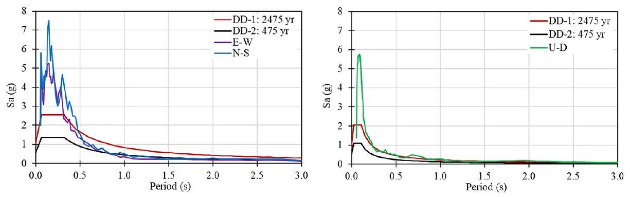
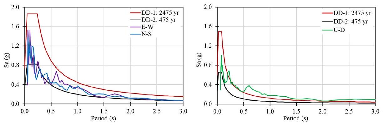
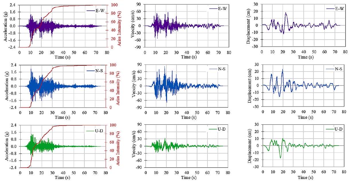
تم تسجيل الزلازل بواسطة العديد من محطات الزلازل الموجودة في شبكة الحركة القوية الوطنية التركية التابعة لـ AFAD. تم الإبلاغ عن بعض محطات حركة الأرض الواقعة في المنطقة المتأثرة بالزلزال والتي سجلت قيم تسارع الأرض الأقصى (PGA) اعتبارًا من 2 نوفمبر 2023 في الجداول 3 و 4 لزلزال بازارجيك.زلزال إلبستان )، على التوالي. مسافة المحطات إلى مواقع مركز الزلزال ( سرعة موجة القص في تربة المحطة ( )، وفئات التربة المقابلة المحددة في كود الزلازل التركي للبناء 2018 (TBEC 2018) مذكورة في تلك الجداول أيضًا. تم تسجيل أقصى قيم التسارع الأرضي (PGA) في المحطة 4614 لزلزال بازرك. ( ) كـ 2.056 جرام في الاتجاه الشرقي الغربي (E-W)، 2.079 جرام في الاتجاه الشمالي الجنوبي (N-S)، و 1.613 جرام في الاتجاه العلوي السفلي (U-D). كانت 0.533 جرام في الاتجاه E-W و 0.648 جرام في الاتجاه N-S لزلزال إلبستان ( تم تسجيل 0.622 جرام في اتجاه U-D في المحطة 4631. بعض الرسوم البيانية لتاريخ الزمن للتسارع والسرعة والإزاحة للمحطات ذات أقصى قيم PGAs موضحة في الأشكال A1 و A2 في الملحق. علاوة على ذلك، تم رسم كثافات أرياس المحسوبة مع التسارعات في نفس الأشكال. كما تم توضيح طيف استجابة التسارع المحسوب في الأشكال 2 و 3 لنفس المحطات.
عند دراسة طيف التصميم المرن الأفقي والعمودي، لوحظ أن طيف التصميم المرن، الذي تم إنشاؤه لمخاطر الزلازل التي لها فترة عودة تبلغ 475 عامًا (والتي تتوافق مع مستوى الزلزال DD-2 في TBEC 2018) قد تم تجاوزه في مواقع كهرمان مرعش، هاتاي، غازي عنتاب، وأديامان خلال زلزال بازارجيك. ). ومع ذلك، فإن طيف التصميم المرن الذي تم إنشاؤه لمخاطر الزلازل التي لها فترة عودة تبلغ 2475 عامًا (والتي تتوافق مع مستوى الزلزال DD-1 في TBEC 2018) قد تم تجاوزه فقط في محافظتي كهرمان مرعش وهاتاي. علاوة على ذلك، خلال
الجدول 3 محطات حركة الأرض وقراءات PGA المسجلة لزلزال بازارجيك ) (تاداس 2023)
رمز المحطة
مقاطعة
منطقة
خط العرض
خط الطول
(كم)
م/ث
فئة التربة
PGA (غ)
N-S
إي-دبليو
يو-دي
0131
أضنة
سايمبيل
37.8566
٣٦.١١٥٣
١٠٣
غير متوفر
غير متوفر
0.159
0.163
0.050
0201
أديامان
مركز
37.7612
٣٨.٢٦٧٤
١٢٠
391
زد سي
0.483
0.897
0.325
2104
ديار بكر
إرغاني
٣٨.٢٦٤٤
٣٩.٧٥٩٠
262
غير متوفر
غير متوفر
0.074
0.119
0.082
2310
إلازغ
باسكيل
٣٨.٥٧٢٦
٣٨.٨٢٤٥
٢١٢
غير متوفر
غير متوفر
0.062
0.052
0.050
٢٧١٨
غازي عنتاب
إصلاحية
٣٧.٠٠٧٧
٣٦.٦٢٦٦
٤٨
غير متوفر
غير متوفر
0.667
0.643
0.604
٢٧١٢
غازي عنتاب
نورداğı
٣٧.١٨٤٠
٣٦.٧٣٢٨
30
غير متوفر
غير متوفر
0.566
0.604
0.320
٣١٢٩
هاتاي
دفنة
٣٦.١٩١١
٣٦.١٣٤٣
146
٤٤٧
زد سي
1.378
1.222
0.731
٣١٢٦
هاتاي
أنطاكيا
٣٦٫٢٢٠٢
٣٦.١٣٧٥
١٤٤
٣٥٠
زد
1.201
1.019
0.939
4614
كهرمان مرعش
بازارجيك
٣٧.٤٨٥١
٣٧.٢٩٧٧
31
541
زد سي
2.056
2.079
1.613
4616
كهرمان مرعش
تورك أوغلو
٣٧.٣٧٥٤
٣٦.٨٣٨٣
21
٣٩٠
زد سي
0.622
0.437
0.395
7901
كيليس
مركز
٣٦.٧٠٨٨
٣٧.١١٢٣
65
463
زد سي
0.054
0.017
0.051
4414
مالاتيا
كالي
٣٨.٤٠٦٩
٣٨.٧٥٤١
195
غير متوفر
غير متوفر
0.109
0.167
0.052
8002
أضنة
حديقة
٣٧.١٩١٥٦
٣٦.٥٦١٩
٤٤
٤٣٠
زد سي
0.248
0.207
0.343
6304
شانلي أورفا
بوزوفا
٣٧.٣٦٥٠٩
٣٨.٥١٣١
١٣٠
٣٧٦
زد سي
0.215
0.243
0.091
الجدول 4 محطات قياس الحركة الأرضية وقراءات PGA المسجلة لزلزال إلبستان ) (تاداس 2023)
رمز المحطة
مقاطعة
منطقة
خط العرض
خط الطول
(كم)
م/ث
فئة التربة
PGA (غ)
N-S
إي-دبليو
يو-دي
0131
أضنة
سايمبيل
٣٧.٨٥٦٦
٣٦.١١٥٣
١٠٢
غير متوفر
غير متوفر
0.410
0.338
0.087
0213
أديامان
توت
37.79667
٣٧.٩٢٩٥
69
غير متوفر
غير متوفر
0.124
0.129
0.073
٢١٠٧
ديار بكر
تشيرميك
٣٨.١٤٥٩٤
٣٩.٤٨٣٧
196
غير متوفر
غير متوفر
0.029
0.049
0.019
2308
إلازغ
سيفريجي
٣٨.٤٥٠٦٣
٣٩.٣١٠٢
185
٤٥٠
زد سي
0.071
0.049
0.034
٢٧٠٣
غازي عنتاب
شاهين بي
٣٧.٠٥٨
٣٧.٣٥٠٠
١١٥
758
زد سي
0.095
0.065
0.028
3144
هاتاي
حسّة
٣٦.٧٥٦٩١
٣٦.٤٨٥٧
162
٤٨٥
زد سي
0.060
0.080
0.028
4612
كهرمان مرعش
غوكسون
٣٨.٠٢٣٩٥
٣٦.٤٨١٨
67
246
زد
0.648
0.533
0.504
4631
كهرمان مرعش
نورحك
٣٧.٩٦٦٣٣
37.4276
21
٥٤٣
زد سي
0.344
0.396
0.622
7901
كيليس
مركز
٣٦.٧٠٨٨
٣٧.١١٢٣
154
463
زد سي
0.052
0.051
0.023
٤٤٠٦
مالاتيا
أكجاداغ
٣٨.٣٤٣٩
٣٧.٩٧٣٨
70
815
زد بي
0.476
0.417
0.325
8003
أضنة
مركز
٣٧.٠٨٤١٧
٣٦٫٢٦٩٣
141
٣٥٠
زد
0.050
0.068
0.030
6306
شانلي أورفا
أكجا قلعة
٣٦.٧٢٧٧
٣٨.٩٤٧٠
٢١٤
غير متوفر
غير متوفر
0.037
0.028
0.014
الشكل 2 زلزال بازارجيك )، المحطة 4614 (كهرمان مرعش/بازارجيك)، طيف الاستجابة ( فئة التربة: ZC)
الشكل 3 زلزال إلبستان )، المحطة 4406 (مالاتيا/أكجاداغ)، طيف الاستجابة ( فئة التربة: ZB)
زلزال إلبستانبينما تم تجاوز طيف التصميم الذي تم إنشاؤه لـ DD-2 فقط في ملاطية وكهرمان مرعش، لم يتم تجاوز طيف تصميم مستوى زلزال DD-1 في المنطقة باستثناء المحطة 4612 في إلبستان للفترات التي تزيد عن 1.2 ثانية. لم يتم تجاوز أطياف التصميم في أماكن أخرى في المنطقة.
بالإضافة إلى ذلك، تم تحديد أن الزلازل أثرت بشكل رئيسي على المباني ذات الفترات القصيرة التي لها فترة أساسية أقل من 1.0 ثانية وتتناسب مع الهياكل ذات الطوابق المنخفضة والمتوسطة. لذلك، زادت الأضرار في المنطقة لأنها تحتوي بشكل عام على مخزون من المباني ذات الطوابق المنخفضة والمتوسطة. ومع ذلك، بدت المباني ذات الفترات الكبيرة متأثرة فقط في المحطة 4612. علاوة على ذلك، تعرضت المباني ذات البروز الكبير أيضًا لأضرار شديدة في المنطقة لأن المكونات الرأسية للتسجيلات كانت مرتفعة جدًا وتجاوزت طيف التصميم.
4 نظرة عامة على الجيوتقنية
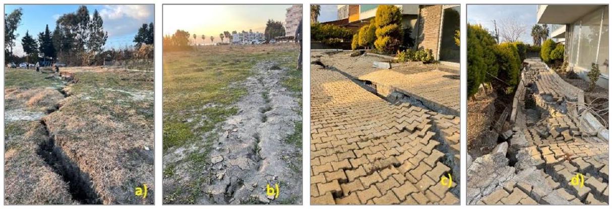
تسببت زلازل كهرمان مرعش الأخيرة في عام 2023 في العديد من المشكلات الجيوتقنية بالإضافة إلى الأضرار الشديدة التي لحقت بالهياكل في المنطقة. خلال المسوحات الميدانية التي أجريت بعد الزلازل، لوحظ أن المنطقة شهدت أضرارًا كبيرة بسبب أسباب جيوتقنية، خاصة في منطقة إسكندرون التابعة لمحافظة هاتاي ومنطقة غولباشي التابعة لمحافظة أديامان. كما تم رصد أحداث انتشار جانبي بالإضافة إلى تسييل التربة في الملاحظات. بخلاف ذلك، تم الإبلاغ عن العديد من حركات الكتلة التي triggered by الزلازل. تعتبر منطقة إسكندرون في هاتاي ومنطقة غولباشي في أديامان مناطق يتم فيها ملاحظة التسييل والانتشار الجانبي بشكل شائع. في هذا القسم، يتم تقديم الملاحظات الجيوتقنية الميدانية بعد الزلازل.
يتم تعريف تسييل التربة على أنه فقدان كبير في القوة والصلابة بسبب تطور ضغوط المياه الزائدة في المسام مما يؤدي إلى عدم وجود إجهاد فعال في التربة خلال حدث زلزالي (Cetin و Ilgaç 2023). تم ملاحظة ظواهر تسييل التربة بشكل رئيسي في منطقة إسكندرون في هاتاي، مما أثر على كل من الهياكل القائمة والمناطق المفتوحة. تم تقديم بعض الأمثلة على الطين الرملية الناتجة عن التسييل المحيطة بالمباني في الجزء الساحلي من إسكندرون في الشكل 4. أظهرت التحقيقات الميدانية هنا أن الرمل المتسييل وصل إلى السطح، خاصة من زوايا وحواف المباني. وقد قامت الهياكل بتسوية موحدة تتراوح بين 30 و 50 سم لكنها حافظت على وظائفها.
الشكل 4 استقرار موحد لمبنى (يسار) وطرد رمل حول هيكل (يمين) في منطقة إسكندرون الساحلية في هاتاي
الشكل 5: مخاريط الرمل وأشكال الفوهات على طول الساحل (يسار) وبعض الأضرار في هياكل الطرق (يمين) في منطقة إسكندرون في هاتاي
علاوة على ذلك، لوحظت ظواهر التسييل وأقماع الرمل في المناطق المفتوحة بالقرب من الساحل. يمكن رؤية مثال على أقماع الرمل والمواد المنبعثة في الشكل 5. بالنظر إلى عدد وحجم الأقماع، تم تحديد أن التسييل قد انتشر على مساحة واسعة هنا. نتيجة لذلك، حدث تسييل واسع النطاق في هذه المنطقة؛ حيث خرجت كميات كبيرة من الماء من سطح الأرض مع الرمل المائع. وقد تسبب ذلك أيضًا في حدوث فيضانات على الساحل، خاصة على طول شارع أتاتورك. كما أصبحت التشوهات المفرطة في هياكل الطرق بسبب الاستقرارات والمواد المنبعثة من الرمل نقطة بارزة في الملاحظات (انظر الشكل 5).
تمت ملاحظة ظواهر تسييل التربة أيضًا في مناطق أنطاكيا (دميركوبرو)، وأرسوز، وكيريخان، ودورتيول في هاتاي. تم توثيق الانتشار الجانبي، الذي لوحظ في الجزء الساحلي من منطقة دورتيول، في الشكل 6أ. تم ملاحظة قذف الرمال في المنطقة الحرة هنا (الشكل 6ب) نتيجةً للاحتكاك الناتج عن التسييل. نتيجةً لهذا الانتشار، تم تشكيل سطح فشل بطول حوالي 900 متر. تم تحديد أن المباني في الجزء الغربي من دورتيول…
الشكل 6: الفشل الناتج عن السيولة الذي تم ملاحظته في منطقة دورتيول في هاتاي
الشكل 7 الأضرار الناتجة عن الانزلاقات الأرضية التي لوحظت في منطقة أنطاكية (يسار) ومنطقة ألتينوزو (يمين) في هاتاي
تعرضت المنطقة لحوالي 80 سم من الاستقرارات الرأسية بالإضافة إلى التشوهات الجانبية. يمكن رؤية بعض الأمثلة الواضحة لهذه التشوهات في الشكل 6c و d.
بصرف النظر عن الانصهار، تم الكشف أيضًا عن أضرار جيولوجية في مركز مدينة أنطاكيا. كانت الأولى من هذه الأضرار هي الانزلاقات الصغيرة في نهر العاصي، الذي يمر عبر وسط المدينة. ومن الأضرار الأخرى الانزلاق الأرضي الكبير الذي حدث في ألتينوزي، والذي يبلغ طوله حوالي 200 متر وعرضه 400 متر. وقد لوحظ أن الصخور الرسوبية الضعيفة تهيمن على قاعدة منطقة الانزلاق. الأضرار المذكورة موضحة في الشكل 7.
تمت ملاحظة الأضرار الجيوتقنية الناتجة عن التسييل أيضًا في منطقة غولباشي في أديامان، التي تتكون من سهول رسوبية رباعية. تحتوي المنطقة عمومًا على وحدتين شابتين: الرواسب الطينية ورواسب المستنقعات. تتكون الرواسب الطينية من طبقات من الحصى والرمل والطين ذات اللون البني الفاتح المائل إلى الأخضر، وتحتوي أحيانًا على شرائط من الطمي. كما أن وحدات الحصى والرمل تتنوع في الطبقات في الاتجاهات الجانبية والعمودية. تقع رواسب المستنقعات حول بحيرة غولباشي، غرب مركز مدينة غولباشي. تتكون عمومًا من طمي أسود، بني داكن، ورمادي داكن جداً، وهي رواسب دقيقة جداً من الطمي والطين وتحتوي على كمية وفيرة من المواد العضوية. نظرًا لأن مستوى المياه الجوفية في هذه المناطق يكون عند السطح أو قريبًا منه، فإنه يختلط مع المستويات الطينية والطمي، مما يمنح الأرض خاصية المستنقع والطين.
أخيرًا، خلال زلازل كهرمان مرعش، لوحظت مشاكل واسعة النطاق في التربة في منطقة غولباشي. واجهت العديد من المباني مشاكل مثل الاستقرار المفرط، والانحراف، والسقوط، وما إلى ذلك. يُعتقد أن هذه المشاكل ناتجة عن ضعف مقاومة الزلازل في…
الشكل 8: رمال مطروحة (يسار) ومبنى مقلوب (يمين) في منطقة غولباشي في أديامان
أداء التربة الشابة الرسوبية مع مستوى المياه الجوفية المرتفع. بالإضافة إلى ذلك، تم تحديد وجود رمال مطروحة في المجال الحر، كما هو موضح في الشكل 8. تم إسقاط مبنى، بالقرب من هذه الرمال المطروحة، على الجانب القصير من الأساس. وهذا يشير إلى أن ظواهر السيولة قد تسببت في العديد من مشاكل التربة في غولباشي. كما تم تحديد أن عمق الأساس المنخفض ونسبة الطول إلى العرض العالية للمبنى قد ساهما في الانقلاب. وبالتالي، تم استنتاج أنه، على غرار الزلازل السابقة، ظهرت مرة أخرى ضرورة أخذ خصائص التربة في الاعتبار في تصميم وبناء البنية التحتية لضمان سلامة البنى التحتية التي سيتم بناؤها في مناطق الزلازل.
5 استجابة الزلازل للهياكل الخرسانية المسلحة المصبوبة في الموقع
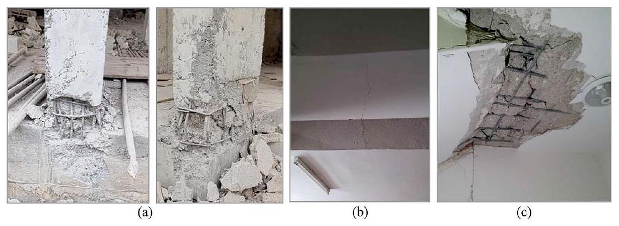
تم بناء معظم الهياكل الخرسانية المسلحة (RC) في المنطقة كخرسانة مصبوبة في الموقع، بما في ذلك الشقق السكنية ذات الطوابق المنخفضة والمتوسطة والمباني المكتبية. تتراوح أعداد طوابقها من 1 إلى 15. تم تصميم بعض المباني لفئة الإشغال السكني مع مساحات تجارية في الطوابق الأرضية بارتفاع طابق أعلى من الطوابق العليا. وبعضها يحتوي أيضًا على طوابق ميزانين. تم تشكيل نظام التحميل في الغالب منها باستخدام إطارات مقاومة للعزم. كما تشمل بعض منها جدران قص. تم بناء معظم المباني الخرسانية المسلحة في المنطقة قبل عام 2000 دون وجود خدمات هندسية كافية. لذلك، تعرض العديد منها لأضرار شديدة وانهيار خلال الزلازل. الأسباب الرئيسية التي لوحظت في المباني المتضررة بشدة أو المنهارة هي ضعف جودة المواد، وتأثير الطابق اللين، وسلوك العمود القوي-العارضة الضعيفة، والامتدادات الكبيرة والثقيلة، وعدم كفاية وصلات العمود-العارضة، وعدم وجود حشوات، وجدران الجملون، وما إلى ذلك. يتم شرح بعض منها بالتفصيل في هذا القسم.
تم بناء المباني السكنية بشكل عام ضمن عملية التطوير والتحديث لمدونة الزلازل التركية في 1967 و1975 و1998 و2018. تعتبر مدونة 1998 مواصفة يتم فيها مناقشة مفهوم اللدونة، وتصميم وصلات العمود-العارضة، وتصميم العمود القوي-العارضة الضعيفة لأول مرة في تركيا فيما يتعلق بالهياكل المقاومة للزلازل. نتيجة للتحقيقات الميدانية في نطاق هذه اللائحة، لوحظ أن الأعمدة تحتوي على مقاطع ضعيفة مقارنة بالعارضات وأن التصاميم غير مناسبة لمبدأ العمود القوي-العارضة الضعيفة في معظم المباني السكنية في المنطقة. ذلك تسبب في تشكيل مفاصل بلاستيكية في الأطراف العليا والسفلى للأعمدة.
الشكل 9 أمثلة على المفاصل البلاستيكية في أسفل الأعمدة (أ)، تشققات الانحناء في العارضات (ب)، والأضرار في هبوط السلالم (ج)
في جميع أنحاء المنطقة. تسبب ذلك في تشكيل مفاصل بلاستيكية في الأطراف العليا والسفلى للأعمدة.
تم ملاحظة أن المخزون العام من المباني يتكون من أنظمة إطارية ذات نسب أبعاد منخفضة. بينما يقلل هذا من القوة الزلزالية على الهيكل، فإنه يتسبب أيضًا في تصرف الهياكل بشكل مرن ولها فترات زمنية أكبر. في الواقع، في الاستطلاعات الميدانية التي أجريت في جميع أنحاء المنطقة، تسببت وصلات الأعمدة في أساس الطابق الأرضي أو جدران القبو في حدوث مفاصل حتى في المباني الجديدة. بسبب الانزلاقات الكبيرة، لوحظ أن الخرسانة قد تحطمت، وأن التسليح قد انحنى أو تمزق في المناطق التي حدثت فيها المفاصل. في المباني ذات الطوابق الأرضية الصلبة، لوحظت المفاصل في نقاط نهاية أعمدة الطابق الأرضي (الشكل 9أ). كما لوحظت تشققات الانحناء والقص الناتجة عن القوى الزلزالية في العارضات (الشكل 9ب). تم ملاحظة الأضرار في العارضات بسبب الالتواء وهبوط السلالم بسبب تأثير الالتواء (الشكل 9ج).
5.1 جودة الخرسانة الضعيفة وسوء وضع الخرسانة
تعتبر جودة الخرسانة واحدة من أهم المعايير في أداء الهياكل. لذلك، تم تعريف الحد الأدنى لجودة الخرسانة المستخدمة في المباني على أنه 18 ميغاباسكال في مدونة 1975، و20 ميغاباسكال في مدونتي 1998 و2007، و25 ميغاباسكال في مدونة الزلازل التركية 2018. ومع ذلك، على الرغم من وجود قيم حدية لجودة الخرسانة في اللوائح، فقد أظهر فحص عينات الخرسانة المأخوذة من الهياكل المتضررة خلال الزلازل أن جودة الخرسانة بعيدة جدًا عن الحدود المحددة في المواصفات. تشمل الأسباب نقص نسبة الخلط المناسبة، وغياب تدرج الحصى المناسب (حصى كبير الحجم وذو سطح أملس)، ونقص الاهتزاز، والانفصال، ووجود مواد غريبة في الخرسانة (مثل البلاستيك، والورق، والخشب، وما إلى ذلك). وقد حددت الملاحظات الميدانية بعض العيوب التي تؤثر مباشرة على جودة الخرسانة، مثل أحجام الحصى غير المناسبة، والانفصال، ووجود مواد غريبة.
تم بناء معظم المباني التي شيدت قبل عام 2000 باستخدام خرسانة مصنوعة يدويًا مختلطة ومصنعة بواسطة العمل البشري. لذلك، لديها أخطاء شائعة مثل خلط الخرسانة الخاطئ (نسبة خاطئة من الماء، والأسمنت، والركام)، ونسبة أسمنت منخفضة، ووجود مواد عضوية وغير عضوية في الخلط، وركام صغير جدًا أو ضخم، وسوء وضع الخرسانة (انفصال ثقيل)، وما إلى ذلك. بعض أمثلة جودة الخرسانة الضعيفة والانفصال موضحة في الشكل 10.
الشكل 10 أمثلة على جودة الخرسانة الضعيفة (أ) وسوء وضع الخرسانة (الانفصال) (ب)
5.2 جودة الفولاذ المسلح الضعيفة، والتآكل، وسوء وضع التسليح
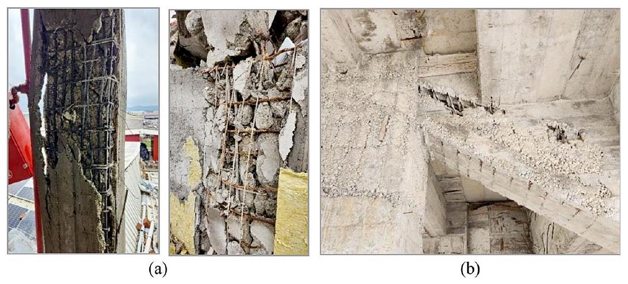
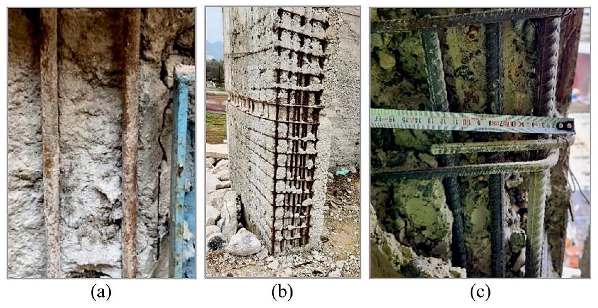
يجب أن يتم إنشاء الربط بين الخرسانة والتسليح لكي تظهر العناصر الهيكلية الخرسانية المسلحة السلوك اللدني المتوقع. الربط بين الخرسانة والتسليح هو معلمة حاسمة تمكن هذين المادتين من العمل معًا. يتم إنتاج التسليح المموج عن طريق إنشاء نتوءات على سطح التسليح لزيادة الربط. ومع ذلك، بينما لم يكن استخدام التسليح المموج إلزاميًا في الماضي، أصبح إلزاميًا في عام 1998 في مدونة الزلازل التركية. حتى ذلك الحين، أدى استخدام التسليح الأملس والخرسانة ذات الجودة الضعيفة إلى هياكل خرسانية مسلحة ذات روابط ضعيفة (Olabi et al. 2022). وقد وُجد أن بعض هذه الهياكل تحتوي أيضًا على تآكل في التسليح. بسبب فقدان المقطع الناتج عن التآكل في التسليح، يضعف الربط، وتنخفض قدرة التحميل لأعضاء RC (Less et al. 2023). بالإضافة إلى ذلك، تم ملاحظة ممارسات غير متوافقة مع التفاصيل التنظيمية في وضع التسليحات العرضية (الخطافات) في العناصر الهيكلية، مثل المسافات غير الكافية، وغير المنتظمة، وبدون خطافات، والمسافات الزائدة. كما في الزلازل السابقة، تسببت التسليحات غير الكافية، والجودة الضعيفة، والتسليح الأملس، وتآكل التسليح، وسوء العمل في التسليح والخرسانة في أضرار كبيرة للهياكل الخرسانية المسلحة خلال زلازل كهرمان مرعش 2023.
بالإضافة إلى ذلك، لوحظ أن الفولاذ المسلح الأملس كان يستخدم عمومًا في المباني التي شيدت قبل عام 2000. كما كان للتسليح الفولاذي تآكل كبير بسبب عدم كفاية غطاء الخرسانة (الشكل 11أ). كما تم اكتشاف انفصال الخرسانة في هذه المباني (الشكل 11ب). في العديد من المباني، تم ثني الخطافات بشكل خاطئ بزاوية 90 درجة بدلاً من 135 درجة، كما هو منصوص عليه في TBEC 2018 (الشكل 11ج). في العديد من المباني في المنطقة، لوحظ أن قضبان التسليح البارزة من الأعمدة والجدران من الأساس لم تتوافق مع متطلبات طول التداخل المحددة في اللوائح. في هذه المناطق، بسبب نقص المسافة المناسبة بين قضبان التسليح وثني قضبان التسليح بزاوية 90 درجة، تشكلت مفاصل بلاستيكية في أسفل الأعمدة، مما تسبب في تشقق الخرسانة وتشوه التسليح.
الشكل 11 تسليح أملس غير مموج وتآكل كبير (أ)، غطاء خرسانة غير كافٍ وانفصال كبير (ب)، وخطافات مثنية بشكل خاطئ (مثنية بزاوية 90 درجة) (ج)
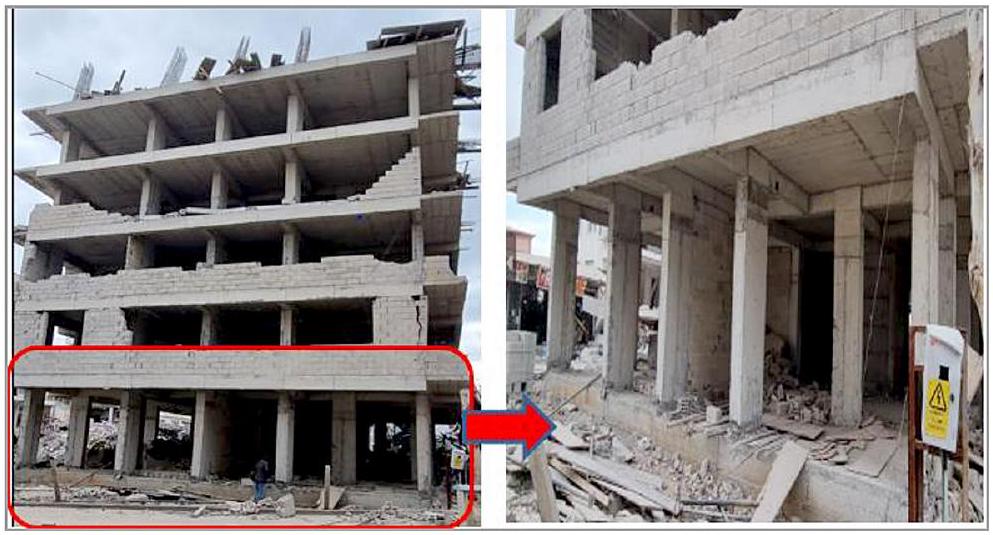
5.3 تأثيرات الطابق اللين في إنشاءات الألواح المموجة
تم فحص المباني الخرسانية المسلحة المتضررة بشدة والمنهارة، والتي تم بناؤها عمومًا بعد عام 2000 في المستوطنات ذات الكثافة السكانية العالية مثل نورداجي، وإسلامية، وبازارجيك، وتورك أوغلو، وكيريخان، وأنطاكية، عن كثب في منطقة ما بعد الزلزال. من الجدير بالذكر أنها تتمتع بميزات معمارية مشابهة وتم ترتيبها بنفس نوع نظام التحميل، خاصة لأعضاء الطابق. كما يتضح من الأشكال 12 و13، تم تصميم الطابقين الأولين من هذه المباني متعددة الطوابق لأغراض العمل التجاري، وتستخدم الطوابق فوقها كمناطق سكنية مع امتدادات كبيرة وثقيلة. وقد لوحظ في الميدان أن هذه الأنواع من المباني السكنية ذات الأخطاء الهندسية والمعمارية المماثلة فشلت أمام القوى الزلزالية.
علاوة على ذلك، عند فحص مخزونات المباني في المناطق المتضررة من الزلزال، تم استخدام الألواح المضلعة ذات الاتجاه الواحد بشكل واسع في أنظمة التحميل للمباني التي تتكون من خمسة إلى ثمانية طوابق. من الملحوظ أن العناصر الهيكلية الرأسية التي تحمل هذه الأنواع من الألواح الأرضية لم يتم دعمها بواسطة جدران القص كما هو محدد بوضوح في TBEC (2018). تعرضت العديد من الهياكل السكنية التي تحتوي على أنظمة الألواح المضلعة (باستخدام كتل البريك légères أو الفوم بين عوارض الأرضية) لأضرار شديدة بسبب عدم كفاية القص.
الشكل 12 آلية الانهيار بسبب تأثير الطابق اللين: تأثيرات P-دلتا مع قوى قصور إضافية عمودية
الشكل 13 أمثلة على المباني النموذجية في المنطقة المتضررة من الزلزال والأضرار الهيكلية الكبيرة بسبب أخطاء في التصميم الهندسي والمعماري
المقاومة لأنهم لم يتمكنوا من إظهار سلوك الحجاب الحاجز الصلب. من الواضح أن تطبيقات الألواح المضلعة في الهياكل الخرسانية المسلحة التي تتعارض مع القيود المفروضة على مثل هذه الألواح الخالية من الأعمدة في أكواد الزلازل قد تسببت في أضرار جسيمة أو تدمير ناتج عن تأثير الطابق اللين. لم يتم استهلاك الطاقة الزلزالية المنقولة إلى الهيكل كما هو مطلوب عند نهايات الأعمدة بما يتماشى مع مبدأ العمود القوي – العمود الضعيف. على العكس من ذلك، أدت نقاط استهلاك الطاقة إلى تشكيل مفاصل بلاستيكية في نهايات الأعمدة الكاملة للطابق الأرضي خلال الاهتزازات الأولية الفورية لحركة الأرض الزلزالية، مما جعل الهيكل غير قادر على تحمل قوى القص الزلزالية. في النهاية، يمكن رؤية بوضوح في الشكل 12 أن الطوابق السكنية العليا لمثل هذه المباني تصبح غير قابلة للاستخدام بسبب حركتها الصلبة مقارنة بالطوابق السفلية التي لا تهتز خلال فترة الاهتزاز.
يجب أن يُلاحظ أيضًا أن التسارعات الرأسية الناتجة عن زلازل كهرمانماراش 2023 كانت فعالة مثل مكونات التسارع الأفقي. لذلك، تعرضت المباني المصممة بألواح أرضية مضلعة لقوى زلزالية كبيرة. في هذه الحالة، يؤدي بناء الألواح المضلع إلى تحميل محوري إضافي على العناصر الهيكلية الرأسية حيث لا يمكنها أن تظهر مقاومة كافية ضد التسارعات الرأسية العالية مثل الألواح المدعومة بواسطة عوارض ثنائية الاتجاه التقليدية. بينما انخفضت لحظات قدرة التحمل في أعمدة الطابق الأرضي بشكل كبير مع زيادة الحمل المحوري، ظهرت تأثيرات اللحظة الثانية بسبب الطلب المفرط على الإزاحة الناتجة عن الزلزال على هذه الطوابق، وزادت لحظة التصميم على هذه العناصر الحاملة بشكل كبير (الشكل 12). كما هو موضح في الشكل 13، تأثرت استقرار عناصر الأعمدة الفردية في الطابق الأرضي سلبًا بزيادة عدد المفاصل البلاستيكية التي تحفز آلية الانهيار بسبب الطلب على انحراف الطوابق الكبير غير المرغوب فيه اعتمادًا على القوى العمودية الإضافية.
لم يتم تصميم أنظمة التحميل الجانبي ذات مستوى المرونة العالي المقترحة للأرضيات المضلعة في المناطق المتأثرة بالزلازل عمومًا وفقًا لرموز الزلازل التركية التي تتضمن أحكام تصميم خاصة لتجنب تأثيرات الطوابق الضعيفة. نتيجة لنمذجة الأرضية ك diaphragme صلب في التحليل الهيكلي المدعوم بالحاسوب، تم تحديد أن أحمال الزلازل لا يمكن نقلها بالكامل إلى العناصر الرأسية بشكل صحيح. يعتبر كود الزلازل التركي أن أنظمة التحميل في المباني ذات الأرضيات المضلعة غير المدعومة بجدران القص لها مرونة محدودة. ومع ذلك، فإنه يسمح أيضًا ببناء مثل هذه المباني في المناطق ذات النشاط الزلزالي المنخفض. بعبارة أخرى، فإنه يضاعف الأحمال الزلزالية لتصميم الهياكل للأرضيات المضلعة مقارنة بأنظمة الألواح ثنائية الاتجاه.
5.4 سلوك الشعاع القوي والعمود الضعيف
خلال الزلازل، تتعرض مناطق وصلات الأعمدة والعوارض لقوى كبيرة. إذا تجاوزت هذه القوى قوة العمود والعارضة، تتشكل مفاصل بلاستيكية في هذه المناطق. من أجل منع الفشل المفاجئ والهش، يُرغب في تشكيل هذه المفاصل البلاستيكية في نهايات العوارض بدلاً من نهايات الأعمدة. هذا يضمن مبدأ سلوك العمود القوي والعارضة الضعيفة، كما هو محدد في أكواد التصميم الزلزالي. علاوة على ذلك، لضمان صلابة كافية في هذه المناطق، يجب تكثيف التعزيز العرضي على طول منطقة الاحتواء وفقًا للمعايير المحددة في المواصفات. ومع ذلك، كشفت التحقيقات الميدانية أن الممارسات المذكورة سابقًا لم تُنفذ بشكل كافٍ، مما ألحق أضرارًا كبيرة بالهياكل.
بالإضافة إلى ذلك، فإن قانون الزلازل التركي لعام 1998 هو الأول في تركيا الذي يتناول مفهوم المرونة في تصميم الهياكل التي لن تنهار في الزلازل، بالإضافة إلى تصميم مناطق وصل الأعمدة والعوارض وتصميم الأعمدة القوية والعوارض الضعيفة. نتيجةً للاستطلاعات الميدانية التي أجريت بموجب هذا التنظيم، لوحظ أن المباني التي تم بناؤها قبل عام 1998 تحتوي على أعمدة ذات مقاطع عرضية أضعف مقارنة بالعوارض. لم يتم تصميم معظم المباني السكنية في المنطقة لتتوافق مع مبدأ العمود القوي والعارضة الضعيفة. لذلك، تعرضت تلك المباني لأضرار شديدة أو انهارت خلال زلازل كهرمان مرعش. أخيرًا، أدت المقاومة غير الكافية للأعمدة مقارنة بالعوارض إلى تكوين شقوق قص وحُلق في نهايات الأعمدة العليا والسفلى.
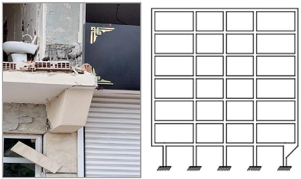
5.5 بروز كبير وثقيل
يتم النص في العديد من أكواد تصميم الزلازل على أنه يمكن منع الانحرافات الخارجية التي قد تحدث من حيث الكتلة والصلابة والقوة من خلال ترتيب نظام هيكلي متماثل. ونتيجة لذلك، يمكن تحقيق سلوك زلزالي يمكن التنبؤ به. عند ملاحظة المباني المتضررة والمهدمة في المنطقة، تم تحديد أن العديد من المباني
الشكل 14 أمثلة على تصميم عمود ضعيف مع شعاع قوي والأضرار التي لحقت بالأعمدة
الشكل 15 أمثلة على البروزات الكبيرة والثقيلة على المباني الخرسانية المسلحة في المنطقة المتضررة من الزلزال
الشكل 16 أمثلة على تلف الأعمدة بسبب البروز الكبير (أ) وانهيار مبنى بسبب الطوابق الإضافية (ب)
كانت تقع بشكل محدد على الشوارع الرئيسية ولها بروزات واسعة تمتد إلى 1.5 متر. علاوة على ذلك، لم تكن الأعمدة التي تحمل تلك البروزات متصلة بالعوارض، مما تسبب في تشكيل نظام إطار غير متماسك. لذلك، لم تتمكن الأعمدة من العمل معًا أو توفير نقل مناسب للأحمال (الشكل 15). علاوة على ذلك، في تصميم المباني المقاومة للزلازل، من المهم وضع جدران القص التي يمكن أن تتحمل جزءًا كبيرًا من قوى الزلزال. في المنطقة، حتى لو تم تضمين جدران القص في المباني، لوحظ أنها لم تكن موضوعة بشكل متماثل في الهياكل. أدت عدم الانتظام الناتج في الالتواء وتأثيرات العزم الإضافية الناتجة عن البروزات الثقيلة إلى تشكيل مفاصل بلاستيكية في المناطق النهائية لجميع الأعمدة في المحور الخارجي (الشكل 16أ).
بالإضافة إلى ذلك، واحدة من أهم المشاكل الهيكلية التي لوحظت في المناطق المتأثرة بالزلازل هي أن المباني القائمة قد اكتملت بإضافة طوابق جديدة على الهياكل على مر السنين دون وجود أي خدمات هندسية. خلال بناء هذه الطوابق الإضافية، لم يتم أخذ نظام التحميل للطابق القائم، واستمرارية العناصر الرأسية في الطوابق الجديدة، والفواصل الباردة بين الطوابق، وتقنيات البناء، واختلافات المواد في الاعتبار. على سبيل المثال، تم بناء المبنى في الشكل 16ب في البداية كطابق أرضي من الطوب بطابق واحد. على مر السنين، تم إنشاء هيكل خرساني مسلح مكون من ثلاثة طوابق.
الشكل 17 مثال على عمود متصل بنهاية العوارض المتدلية (الرسم الأيمن من TBEC 2018)
تمت الإضافة، وأخيرًا، اكتمل بسقف أرضي من الإطار الفولاذي. بينما ظل الطابق الأرضي الأصلي قائمًا، انهارت الطوابق الإضافية المبنية فوقه خلال الزلازل.
أخيرًا، العديد من الأكواد الزلزالية لا تسمح أبدًا بوضع الأعمدة على قمة أو نهاية العوارض المتدلية أو على الأجزاء المكونة من الأعمدة السفلية لأي طابق من المباني. ومع ذلك، خلال المسوحات الميدانية، تم ملاحظة حدوث مفاصل بلاستيكية في بعض المباني بسبب انحناء التعزيز وصب الخرسانة في أسفل الأعمدة نتيجة لتلك الممارسة (الشكل 17).
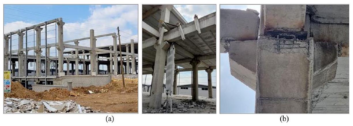
تستخدم الهياكل مسبقة الصنع المبنية بعناصر خرسانية مسلحة مسبقة الصنع كمناطق إنتاج في الصناعة. يتم إنتاج مكونات أنظمة البناء هذه في بيئة مصنع بطريقة محكومة. يوفر التجميع الأسرع والمتحكم فيه للأعضاء الهيكلية في الميدان الوقت والتكلفة. العناصر الهيكلية المنتجة بهذه الطريقة تتفوق على تقنيات البناء التقليدية بقوتها وثباتها الأبعاد. يعتمد الإنتاج بشكل أساسي على الزراعة وتربية الحيوانات، صناعة النسيج، صناعة المعادن والصلب، صناعة الورق، إنتاج الغذاء، وإنتاج الآلات الزراعية في المنطقة المتضررة من الزلزال.
بعد زلازل كهرمان مرعش 2023، تم إجراء تحقيق ميداني على الهياكل مسبقة الصنع في وحول محافظة كهرمان مرعش، وتمت ملاحظة أنماط الأضرار على تلك الهياكل. كان النوع الأكثر شيوعًا من الأضرار هو سقوط العوارض الأفقية التي تستند على دعامات الأعمدة بفصل وصلاتها. وبالمثل، كانت الأضرار في نهايات عوارض السقف التي لم تكن متصلة بشكل كافٍ بالعوارض وسقوطها إلى الأرض شائعة (الشكل 18). كانت الأضرار ناتجة عمومًا عن عدم قدرة العناصر الهيكلية على الاستجابة للازاحة الزلزالية ومتطلبات الدوران في مناطق الوصل، وضعف الأعضاء في الوصلات، والاتصالات الدبوسية التي لم تُملأ بمونة الأسمنت. بسبب نقص تفاصيل الاتصال، انفصلت أيضًا عناصر الأرضية مسبقة الصنع الجالسة على العوارض عن
الشكل 18 أمثلة على عدم كفاية تثبيت عوارض السقف بالعوارض (أ)، والأضرار في مناطق الوصل (ب)
الشكل 19 أضرار الأرضية بسبب تفاصيل الاتصال الضعيفة (يسار) وهيكل خرساني مسبق الصنع بأعمدة ضعيفة وعوارض سقف ثقيلة (يمين)
نقاط الاتصال، مما أدى إلى تعطيل سلامة المبنى ولم تتمكن من إظهار سلوك الحجاب الحاجز المفترض توفيره عند مستويات الأرضية (الشكل 18).
كشفت خطط النظام المعماري والهيكلي، التي تم ترتيبها بشكل غير صحيح، عن آثار الالتواء وتسببت في انفصال العوارض عن الأعمدة. على سبيل المثال، تم بناء طابق ميزانين بارتفاع 5 أمتار في جزء من مبنى خرساني مسبق الصنع بارتفاع طابق 10 م (انظر الشكل 19). في هذين المنطقتين، حدثت الأضرار بسبب السلوك الصلب والمرن المتزامن الذي يختلف اعتمادًا على أطوال الأعمدة وحجاب الميزانين. علاوة على ذلك، لوحظت أضرار شديدة وانهيارات على نطاق واسع في الهياكل مسبقة الصنع ذات الأعمدة الضعيفة والعوارض الثقيلة التي لم تتمكن من توفير الاستقرار الأفقي (الشكل 19).
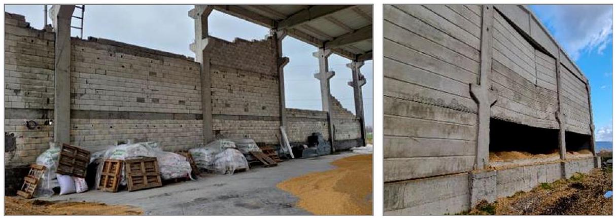
بالإضافة إلى ذلك، كانت أضرار الجدران الداخلية في المباني مسبقة الصنع واسعة الانتشار أيضًا. تم استخدام قوالب فارغة منخفضة القوة، تُعرف عمومًا باسم “بims”، على نطاق واسع في الهياكل الموجودة في المنطقة. بسبب العوارض الخرسانية المسلحة الأفقية المنخفضة التي توفر الاستقرار في الجدران ذات الامتداد الكبير وتجاوزها الحد الأقصى لطول الجدار غير المدعوم، حدثت حركة خارج المستوى في الجدران خلال زلازل كهرمان مرعش (الشكل 20). علاوة على ذلك، كانت الألواح التي تخرج من الفتحات المدعومة على الأعمدة أو الحركة خارج المستوى واحدة من الأضرار الشائعة والنمطية التي لوحظت في الألواح الجدارية مسبقة الصنع (الشكل 20). أدى الفشل في تنفيذ الجودة الدقيقة اللازمة للوصلات خلال مراحل الإنتاج والتجميع، وملء الدبابيس بمونة الأسمنت منخفضة القوة أو عدم ملئها على الإطلاق، والاستخدام غير الكافي أو عدم استخدام الصواميل، والغسالات، واللحامات إلى أضرار كبيرة على الألواح الجدارية مسبقة الصنع. أخيرًا، تم ملاحظة تشققات انحناء في الطرف السفلي من الأعمدة، وانفصال القشرة
الشكل 20 أمثلة على الجدران ذات الامتداد الكبير التي تتجاوز الحد الأقصى لطول الجدار غير المدعوم على الجدران (يسار) وأضرار الانقلاب خارج المستوى على الألواح الجدارية مسبقة الصنع (يمين)
الخرسانية، وانبعاج التعزيزات، وأضرار تصل إلى تمزق التعزيزات أيضًا في عقد الأعمدة والأساسات.
7 الاستجابة الزلزالية للهياكل الحجرية
الهياكل التاريخية المعمارية هي أغلى الكنوز التي تعكس تاريخ المجتمعات والأمم وتكشف عن ثقافتها وحضارتها. يتم الحفاظ على مثل هذه الهياكل بعناية في جميع أنحاء العالم، حيث تظهر مستويات وأنماط حياة المجتمعات في الثقافة والفن، مما يربط ماضي المجتمعات بمستقبلها. تُستخدم تقنية البناء بالحجر في جميع أنحاء العالم لبناء المباني المنخفضة والمتوسطة الارتفاع. الخشب، والطين، والطوب، والحجر هي أقدم مواد البناء المعروفة. لا تزال هذه المواد تُستخدم اليوم بسبب فعاليتها من حيث التكلفة، ومتانتها، وتوافرها المحلي، وخصائصها العازلة للصوت. تم تحديث الأكواد الزلزالية عدة مرات لتصميم وبناء مثل هذه الهياكل (غونيدين وآخرون 2021).
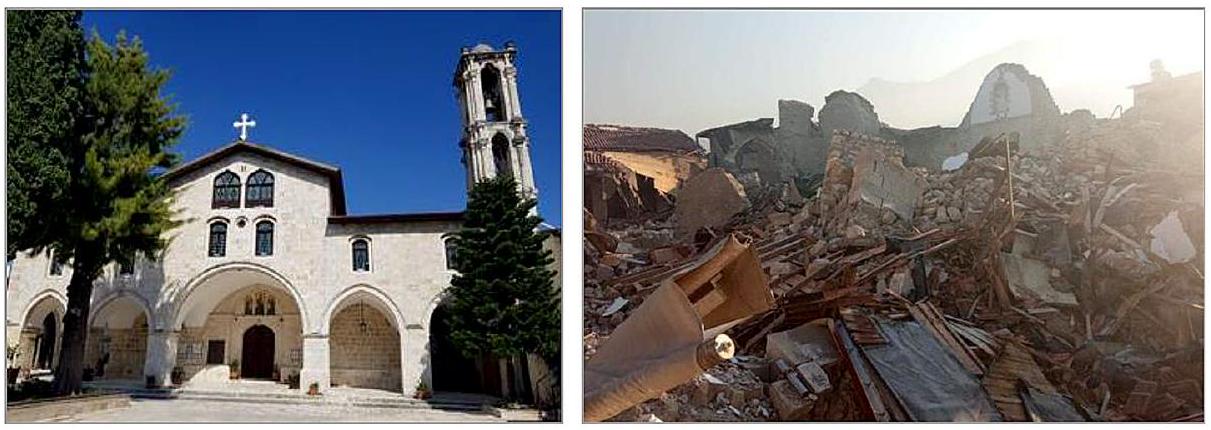
أظهرت البيانات التي تم الحصول عليها من المسوحات الميدانية بعد زلازل كهرمان مرعش ضعفًا كبيرًا في مخزون المباني الحجرية التي تم بناؤها باستخدام الطرق والمواد التقليدية. تم بناء معظم المباني في المنطقة على شكل هياكل مقوسة وقباب باستخدام الطوب الطيني المطبوخ، والحجر المكسر، أو البناء بالحجر المقطوع. معظم المباني هي هياكل حجرية غير مسلحة تتميز بجدران حجرية مكسرّة ذات سطحين ناعمين متصلين. في بعض المباني، تم بناء الحواجز بين الطوابق باستخدام الخشب، والصلب، ومواد الطوب باستخدام البناء بالحجر. بالإضافة إلى المساكن، تأثرت المباني العامة والمصانع في المنطقة أيضًا بزلازل كهرمان مرعش. تسببت في أضرار كبيرة وانهيارات، خاصة في محافظات هاتاي، وأديامان، وكهرمان مرعش، وغازي عنتاب.تم تدمير أو تضرر بشدة العديد من المباني التاريخية في المنطقة. حدثت أضرار زلزالية على مقياس زلزالي كبير من الدرجة IX-XI في أنطاكية وكهرمان مرعش (KOERI، 2023). زاد الطلب المفرط على حركة الأرض في تسارع الأرض الأقصى من الأضرار التي لحقت بالهياكل المتضررة من الصدمات السابقة.
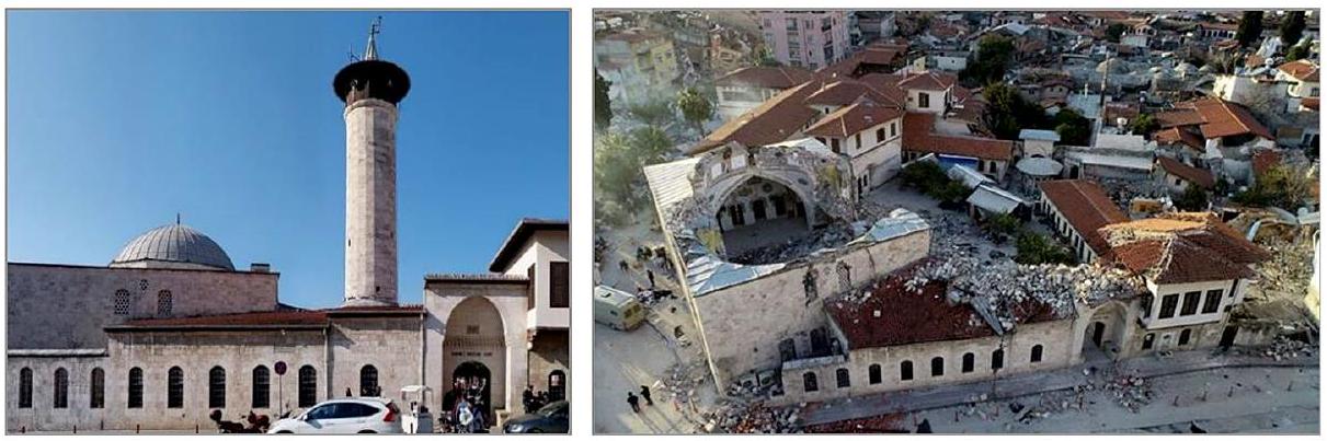
انهار أكثر من نصف المباني في المركز التاريخي لمدينة هاتاي. من بينها، تعتبر مساجد حبيب النجار، ومسجد صريمي، وكنيسة القديسين بطرس وبولس التاريخية، والكنيسة اليونانية الأرثوذكسية، وكنيسة إسكندرون الإيطالية الكاثوليكية من الهياكل الأساسية
الشكل 21 مسجد حبيب النجار، أنطاكية، هاتاي، قبل (يسار) وبعد (يمين) زلازل كهرمان مرعش
الشكل 22 مسجد صريمي، أنطاكية، هاتاي، قبل (أ) وبعد (ب) زلازل كهرمان مرعش
من تراثنا المعماري التاريخي التي تضررت جزئيًا أو انهارت في المركز التاريخي لمدينة هاتاي. تم تصوير حالات تلك الهياكل قبل وبعد الزلزال في الأشكال 21 و22 و23 و24، على التوالي.
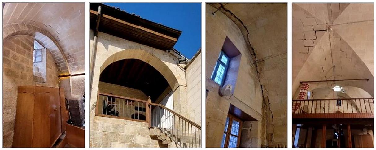
علاوة على ذلك، كانت الهياكل التاريخية التي تم التحقيق فيها في غازي عنتاب، والتي بُنيت بشكل رئيسي بين القرن السابع عشر ونهاية القرن التاسع عشر، تؤدي استجابة زلزالية أفضل بسبب ابتعادها عن خط الصدع. تم فحص أمثلة من المباني التاريخية المستعادة التي تظهر أداءً جيدًا في المركز التاريخي لمحافظة غازي عنتاب. نظرًا لأن هذه الهياكل بعيدة نسبيًا عن خط الصدع، فقد تعرضت الهياكل لتسارعات أقل من مستوى الزلزال التصميمي لـ TBEC 2018. في المباني التاريخية التي تم فحصها في محافظة غازي عنتاب، لوحظت تشققات انزلاقية في الجدران الرئيسية، وفتحات في الوصلات، وانفصالات محلية في الطبقات الخارجية للجدران (انظر الشكل 25). كانت هناك أضرار في وصلات الأقواس والقباب، وتم الكشف عن حركات خارج المستوى في وصلات الجدران والقباب (الشكل 26). لوحظت فتحات في الوصلات، وتشققات عمودية، وانقلاب على القواعد في مآذن المسجد (الشكل 27).
ساهمت العديد من العوامل في استجابة انهيار الهياكل الحجرية خلال زلازل كهرمان مرعش 2023. واحدة من أهم العوامل هي خصائص واتجاه الزلزال (أثر الاتجاه). هذا الأثر أكثر تعقيدًا بالنسبة للمباني التاريخية التي تحتوي على عناصر بناء مختلفة بأشكال هندسية متباينة. إن إنشاء وصلات فعالة بين الألواح الأفقية والجدران الحاملة الرأسية يوفر
الشكل 23 الكنيسة التاريخية للقديسين بطرس وبولس، أنطاكية، هاتاي، قبل (يسار) وبعد (يمين) زلازل كهرمان مرعش
الشكل 24 كنيسة أنطاكية الأرثوذكسية اليونانية (يسار) وكنيسة إسكندرون الكاثوليكية الإيطالية (يمين) بعد زلازل كهرمان مرعش
الشكل 25 أمثلة على الأضرار التي لحقت بالجدران الرئيسية الهيكلية
الهياكل ذات السلوك الهيكلي الشبيه بالصندوق، تمنع الواجهات الخارجية من السقوط أثناء الزلازل، وتزيد من أداء الزلازل. وقد لوحظ في المنطقة أن الحواجز الأفقية منعت آلية السقوط خارج المستوى لجدران الواجهة. علاوة على ذلك، ساهم استخدام مشدات الفولاذ في تقنية البناء بالحجر في منع انهيارات الجدران. نتيجة لذلك، نظرًا لأن معظم المباني الحجرية التراثية المعمارية لا تزال قيد الاستخدام في المنطقة وتركيا، يجب ملاحظة أنها عرضة للتأثيرات الزلزالية بسبب كل من كتلتها النوعية العالية وقوتها الشد المنخفضة.
الشكل 26 أمثلة على الشقوق الشد عند الوصلات في الأقواس، والقباب، والحركات خارج المستوى
الشكل 27 أمثلة على الأضرار التي لحقت بالمآذن
نتيجة لذلك، حدثت الأضرار التي لحقت بالمباني الحجرية في المنطقة في شكل فشل قص، وفتح في الوصلات، وحركة خارج المستوى، وانقلاب بسبب ضعف عناصر البناء وجودة الملاط، وصلات الشد الضعيفة، والحواجز الأرضية الضعيفة، وعدم الامتثال لقواعد البناء في وصلات الجدران. في معظم الهياكل الحجرية المتضررة، لوحظ ضعف الاتصال بين الأعضاء الهيكلية وطبقات الجدران، وهيكل غير منتظم، ومواد ضعيفة ومتدهورة. عادةً ما حدث الانهيار خارج المستوى للجدران الرئيسية إما بسبب فشل قوة ضغط المادة أو بفصل أو انزلاق طبقة الجدار. شكل آخر من الأضرار التي لوحظت بعد التشقق هو أن الجدران انقسمت وسقطت خارج المستوى في كتل. ومع ذلك، لوحظ أن المباني الحجرية ذات الأداء الزلزالي الجيد في المنطقة التي تم فحصها تتمتع بالخصائص التالية: (1) توفر وصلة مرتبة جيدًا بين الجدران أو بين الجدار والحاجز سلوك صندوقي فعال، (2) يتم ضمان الاتصال العرضي بين طبقات الجدران بشكل صحيح، (3) وحدات البناء الحجرية لها شكل وترتيب منتظم، و(4) الخصائص الميكانيكية لوحدات البناء والملاط جيدة جدًا.
8 الاستنتاجات
لقد قامت هذه الدراسة بتقييم شامل للجوانب الجيوتقنية والهيكلية بعد زلازل كهرمان مرعش 2023. وقد أسفرت الأبحاث التي أجراها فريق من الخبراء عن رؤى قيمة حول أداء البيئة المبنية، مع الأخذ في الاعتبار عوامل مثل الأضرار الهيكلية، وظروف الموقع المحلية، وبيانات الحركة الأرضية القوية. يتم تلخيص النتائج الرئيسية لهذه التحقيقات كما يلي:
تُعزى هشاشة المستوطنات في منطقة أنطاكية من هاتاي، ومنطقة تورك أوغلو من كهرمان مرعش، ومنطقة غولباشي من أديامان، التي تتميز بارتفاع معدل الهدم والأضرار الهيكلية، إلى مواقعها على رواسب الفيضانات المحيطة بسهل أميك. هذه المناطق، التي تغذيها قيعان بحيرات قديمة ونهر العاصي، تظهر تضخيمًا كبيرًا في سعات الحركة الأرضية الزلزالية بسبب ظروف التربة الناعمة. أدى الفشل في تنفيذ تصاميم الأساسات المقاومة للزلازل للتربة الإشكالية، كما هو موصى به في تقارير المسح الجيوتقني، إلى انهيار العديد من المباني، مما أدى إلى فقدان الأرواح والممتلكات. على الرغم من بُعدها عن مركز الزلزال، إلا أن المستوطنات مثل هاتاي/كيريخان وغازي عنتاب/إسلامية قد شهدت تأثيرًا متزايدًا على انهيارات المباني والأضرار الشديدة بسبب قربها من خطوط الصدع.
كان للمكون العمودي من الحركة الأرضية الناتجة عن الزلزال على طول صدع الأناضول الشرقي تأثير مماثل للمكون الأفقي. وقد زاد ذلك من مشكلة الطابق الناعم في المباني السكنية متعددة الطوابق ذات الأرضيات المتدلية، مما أدى في النهاية إلى انهيار المباني أو جعلها غير صالحة للاستخدام.
تُعزى الأضرار الشديدة أو الانهيار في المباني الخرسانية المسلحة بشكل أساسي إلى عوامل مثل ضعف جودة المواد، وتأثير الطابق الناعم، وسلوك العمود القوي والعارضة الضعيفة، والامتدادات الكبيرة والثقيلة، وعدم كفاية وصلات العمود-العارضة، والجدران غير المحصورة.
تميزت الأضرار الواسعة في الهياكل مسبقة الصنع بفصل العوارض الأفقية عن دعامات الأعمدة، والاتصالات غير الكافية التي أدت إلى انهيارات عوارض السقف، وتعرض السلامة الهيكلية للخطر بسبب ردود الفعل الضعيفة في الوصلات والاتصالات الدبوسية. أدت أخطاء الترتيب المعماري والهيكلي إلى تأثيرات التواء، مما فصل العوارض عن الأعمدة، بينما كانت الأضرار والانهيارات الشديدة شائعة في الهياكل ذات الأعمدة الضعيفة والعوارض الثقيلة. كانت مشاكل الجدران الداخلية أيضًا شائعة، بسبب المواد ذات القوة المنخفضة ونقص التعزيز الأفقي. أخيرًا، أظهرت عقد العمود-الأساس مشاكل هيكلية متنوعة، بما في ذلك شقوق الانحناء، وفصل الخرسانة القشرية، وانبعاج التعزيز، وأضرار في سلامة التعزيز.
تعرضت المباني التاريخية في المنطقة، التي تم بناؤها بفترات اهتزاز أقصر على ظروف تربة أكثر ملاءمة، لأضرار أكثر شمولاً مقارنة بالهياكل الخرسانية المسلحة ذات الفترات الكبيرة. يُعزى هذا الظاهرة إلى وجود تسارعات طيفية أفقية ورأسية أكبر، والتي تعتمد على فترة الاهتزاز وتقنيات البناء. تجلت الأضرار التي لحقت بالمباني الحجرية في المنطقة على شكل فشل قص، وفتح الوصلات، وحركات خارج المستوى، وانقلاب، تُعزى أساسًا إلى ضعف عناصر الهيكل، ونقص جودة الملاط، وضعف وصلات الشد، والحواجز الأرضية الضعيفة، وعدم الامتثال لمعايير البناء في وصلات الجدران.
الملحق أ
الأشكال A1 و A2.
الشكل A1 زلزال بازرجيك (كهرمان مرعش) ( )، المحطة 4614 (كهرمان مرعش/بازرجيك)، تسارع مقابل شدة أرياس، وسرعة وتاريخ الإزاحة ( ، فئة التربة: ZC)
الشكل A2 زلزال إلبستان (كهرمان مرعش) ( )، المحطة 4406 (مالاتيا/أكجاداغ)، تسارع مقابل شدة أرياس، وسرعة وتاريخ الإزاحة ( ، فئة التربة: ZB)
الشكر يتقدم المؤلفون بالشكر الجزيل لمجلس البحث العلمي والتكنولوجي في تركيا (TÜBİTAK) لدعمه وتمويله التحقيقات الميدانية من خلال برنامج 1002-C الكوارث الطبيعية – التحقيق الطارئ الموجه.
مساهمات المؤلفين ساهم جميع المؤلفين في الدراسة بالتساوي. قرأ جميع المؤلفين ووافقوا على النسخة النهائية من المخطوطة.
التمويل تم توفير تمويل الوصول المفتوح من قبل مجلس البحث العلمي والتكنولوجي في تركيا (TÜBİTAK). يتقدم المؤلفون بالشكر لمجلس البحث العلمي والتكنولوجي في تركيا (TÜBİTAK) لدعمه وتمويله التحقيقات الميدانية من خلال برنامج 1002-C الكوارث الطبيعية – التحقيق الطارئ الموجه.
الإعلانات
المصالح المتنافسة ليس لدى المؤلفين أي مصالح مالية أو غير مالية ذات صلة للإفصاح عنها.
الوصول المفتوح. هذه المقالة مرخصة بموجب رخصة المشاع الإبداعي النسب 4.0 الدولية، التي تسمح بالاستخدام والمشاركة والتكيف والتوزيع وإعادة الإنتاج بأي وسيلة أو صيغة، طالما أنك تعطي الائتمان المناسب للمؤلفين الأصليين والمصدر، وتوفر رابطًا لرخصة المشاع الإبداعي، وتوضح ما إذا تم إجراء تغييرات. الصور أو المواد الأخرى من طرف ثالث في هذه المقالة مشمولة في رخصة المشاع الإبداعي الخاصة بالمقالة، ما لم يُشار إلى خلاف ذلك في سطر الائتمان للمواد. إذا لم تكن المادة مشمولة في رخصة المشاع الإبداعي الخاصة بالمقالة وكان استخدامك المقصود غير مسموح به بموجب اللوائح القانونية أو يتجاوز الاستخدام المسموح به، ستحتاج إلى الحصول على إذن مباشرة من صاحب حقوق الطبع والنشر. لعرض نسخة من هذه الرخصة، قم بزيارة http://creativecommons.org/licenses/by/4.0/.
Akıl B, Akpınar K, Üçkardeşler C, Araz H, Sağlam M, Uran ŞB (2008) Doğu Anadolu Fay Zonu Üzerinde Yer Alan Gölbaşı (Adıyaman) Yerleşim Alanındaki Zeminlerin Jeoteknik Özellikleri ve Değerlendirilmesi/ Evaluation of settlement suitability of Gölbaşı (Adıyaman) Town, located on the East Anatolian Fault Zone. Türkiye Jeoloji Bülteni 51(1):43-57
Ambraseys NN (1989) Temporary seismic quiescence: SE Turkey. Geophys J Int 96:311-331. https://doi.or g/10.1111/j.1365-246X.1989.tb04453.x
Barka AA, Kadinsky-Cade K (1988) Strike-slip fault geometry in Turkey and its influence on earthquake activity. Tectonics 7:663-684. https://doi.org/10.1029/TC007i003p00663
Barka A, Reilinger R (1997) Active tectonics of the Eastern Mediterranean region: deduced from GPS, neotectonic and seismicity data. 3
Bulut F, Bohnhoff M, Eken T et al (2012) The East Anatolian Fault Zone: seismotectonic setting and spatiotemporal characteristics of seismicity based on precise earthquake locations. J Geophys Res Solid Earth 117. https://doi.org/10.1029/2011JB008966
Cetin K, Ilgaç M (2023) Reconnaissance Report on February 6, 2023 Kahramanmaraş-Pazarcık (Mw=7.7) and Elbistan (Mw=7.6) Earthquakes. https://doi.org/10.13140/RG.2.2.15569.61283/1
Demir A (2022) Progressive collapse resistance of low and mid-rise RC mercantile buildings subjected to a column failure. Struct Eng Mech 83(4):563-576. https://doi.org/10.12989/sem.2022.83.4.563
Duman TY, Emre Ö (2013) The East Anatolian Fault: geometry, segmentation and jog characteristics. Geol Soc 372:495-529. https://doi.org/10.1144/SP372.14
Emre Ö, Duman T, Özalp S et al (2013) Active Fault Map of Turkey with an Explanatory Text. 1:1,250,000 Scale
Garini E, Gazetas G, Anastasopoulos I (2017) Evidence of significant forward rupture directivity aggravated by soil response in an M w 6 earthquake and the effects on monuments. Earthq Eng Struct Dyn 46:2103-2120. https://doi.org/10.1002/eqe. 2895
Günaydin M, Atmaca B, Demir S et al (2021) Seismic damage assessment of masonry buildings in Elazığ and Malatya following the 2020 Elazığ-Sivrice earthquake, Turkey. Bull Earthq Eng 19:2421-2456. ht tps://doi.org/10.1007/s10518-021-01073-5
ITU (2023) 6 Şubat Kahramanmaraş (Pazarcık, Türkoğlu), Hatay (Kırıkhan), ve 13.24 Mw 7,7 Kahramanmaraş (Elbistan/Nurhak-Çardak) Depremleri Ön İnceleme Raporu (in Turkish), Istanbul Technical University. https://haberler.itu.edu.tr/docs/default-source/default-document-library/ 2023_itu_deprem_on_raporu.pdf. Accessed 1 November 2023
Karabacak V, Özkaymak Ç, Sözbilir H et al (2023) The 2023 Pazarcık (Kahramanmaraş, Türkiye) Earthquake (Mw: 7.7): implications for surface rupture dynamics along the East Anatolian Fault Zone
KOERI, Earthquake Research Institute Department of Earthquake Engineering (2023) Strong Ground Motion and Building Damage Estimations Preliminary Report (v6), Boğaziçi University Kandilli Observatory and. https://eqe.bogazici.edu.tr/sites/eqe.boun.edu.tr/files/kahramanmaras-gaziantep_earthquake_06-0 2-2023_04.17-bogazici_university_earthquake_engineering_department_v6.pdf. Accessed 1 November 2023
Less T, Demir A, Sezen H (2023) Structural performance and corrosion resistance of fiber reinforced polymer wrapped steel reinforcing bars. Constr Build Mater 366:130176. https://doi.org/10.1016/j.conbuildma t.2022.130176
McClusky S, Balassanian S, Barka A et al (2000) Global positioning system constraints on plate kinematics and dynamics in the eastern Mediterranean and Caucasus. J Geophys Res Solid Earth 105:5695-5719. https://doi.org/10.1029/1999JB900351
McKenzie D (1972) Active tectonics of the Mediterranean Region. Geophys J Int 30:109-185. https://doi.or g/10.1111/j.1365-246X.1972.tb02351.x
Nalbant SS, McCloskey J, Steacy S, Barka AA (2002) Stress accumulation and increased seismic risk in eastern Turkey. Earth Planet Sci Lett 195:291-298. https://doi.org/10.1016/S0012-821X(01)00592-1
Olabi MN, Caglar N, Arslan ME et al (2022) Response of nonconforming RC shear walls with smooth bars under quasi-static cyclic loading. Bull Earthq Eng 20:6683-6704. https://doi.org/10.1007/s10518-02 2-01451-7
PSBD (2023) 2023 Kahramanmaraş and Hatay Earthquakes Report (in Turkish), Presidential Strategy and Budget Directorate. https://www.sbb.gov.tr/wp-content/uploads/2023/03/2023-Kahramanmaras-and-H atay-Earthquakes-Report.pdf. Accessed 1 November 2023
Reilinger R, McClusky S, Vernant P et al (2006) GPS constraints on continental deformation in the Africa-Arabia-Eurasia continental collision zone and implications for the dynamics of plate interactions. J Geophys Res Solid Earth 111. https://doi.org/10.1029/2005JB004051
Sagbas G, Garjan RS, Sarikaya K, Deniz D (2023) Field reconnaissance on seismic performance and functionality of Turkish industrial facilities affected by the 2023 Kahramanmaras earthquake sequence. Bull Earthq Eng. https://doi.org/10.1007/s10518-023-01741-8
Şengör AMC, Yilmaz Y (1981) Tethyan evolution of Turkey: a plate tectonic approach. Tectonophysics 75:181-241. https://doi.org/10.1016/0040-1951(81)90275-4
Şengör AMC, Görür N, Şaroğlu F (1985) Strike-Slip Faulting and Related Basin Formation in Zones of Tectonic Escape: Turkey as a Case Study. In: Strike-Slip Deformation, Basin Formation, and Sedimentation. SEPM (Society for Sedimentary Geology) 211-226
TADAS (2023) Turkish Accelerometric Database and Analysis System. Disaster and Emergency Presidency of Türkiye (AFAD), www.tadas.afad.gov.tr. Accessed 1 November 2023
Tan O, Pabuçcu Z, Tapırdamaz MC et al (2011) Aftershock study and seismotectonic implications of the 8 March 2010 Kovancılar (Elazığ, Turkey) earthquake (mw=6.1). Geophys Res Lett 38:L11304. https:// doi.org/10.1029/2011GL047702
Taymaz T, Eyidoğan H, Jackson J (1991) Source parameters of large earthquakes in the East Anatolian Fault Zone (Turkey). Geophys J Int 106:537-550. https://doi.org/10.1111/j.1365-246X.1991.tb06328.x
TBEC (2018) Turkish building Earthquake Code. Turkish Ministry of Environment and Urbanization, Ankara, Türkiye
Utkucu M, Budakoğlu E, Çabuk M (2018) Teleseismic finite-fault inversion of two earthquakes along the East Anatolian Fault Zone in Turkey: the 1998 Adana and 2003 Bingöl earthquakes. Arab J Geosci 11:721. https://doi.org/10.1007/s12517-018-4089-y
Xu J, Liu C, Xiong X (2020) Source process of the 24 January 2020 mw 6.7 East Anatolian Fault Zone, Turkey, Earthquake. Seismol Res Lett 91:3120-3128. https://doi.org/10.1785/0220200124
Publisher’s Note Springer Nature remains neutral with regard to jurisdictional claims in published maps and institutional affiliations.
أيدين دمير aydindemir@sakarya.edu.tr
1 قسم الهندسة المدنية، كلية الهندسة، جامعة ساكاريا، ساكاريا 54050، تركيا
2 قسم الهندسة الجيوفيزيائية، كلية الهندسة، جامعة ساكاريا، ساكاريا 54050، تركيا
معلومات المؤلف الموسعة متاحة في الصفحة الأخيرة من المقالة
Destructive impact of successive high magnitude earthquakes occurred in Türkiye’s Kahramanmaraş on February 6, 2023
Aydin Demir (D) • Erkan Celebi Hakan Ozturk Zeki Ozcan Askin Ozocak Ertan Bol Sedat Sert F. Zehra Sahin Eylem Arslan Zeynep Dere Yaman Murat Utkucu . Necati Mert
Two successive earthquakes with moment magnitudes of (focal depth=8.6 km) and (focal depth=7 km) occurred approximately within 9 h on February 6, 2023, in Türkiye, respectively. The epicenters were the Pazarcık and Elbistan districts of Kahramanmaraş. Both earthquakes occurred in the East Anatolian Fault Zone, one of Türkiye’s two major active fault systems. Between these two severe earthquakes, there was one more big aftershock with a moment magnitude of 6.6 , the epicenter of which was in the Nurdağı District of Gaziantep. Then, on February 20, 2023, another aftershock earthquake with a magnitude of occurred in Yayladağı district of Hatay. As a result of the earthquakes, severe damage occurred in several provinces and districts with a population of around 15 million, and more than 50,000 people have lost their lives. This study presents on-site geotechnical and structural investigations by a team of researchers after the Kahramanmaraş earthquakes. It summarizes the performance of the building environments as a result of on-site assessments, taking into account observed structural damage, local site conditions, and strong ground motion data. The possible causes of the observed damage are addressed in detail. These earthquakes once again revealed the common deficiencies of existing reinforced concrete structures in Türkiye, such as poor material quality, poor workmanship, unsuitability of reinforcement detailing, and inadequate earthquake-resistant construction techniques. Precast concrete and masonry structures in the region were also severely damaged during the earthquakes due to insufficient engineering service, poor materials, deficiencies during construction, etc.
Türkiye and its surroundings, which are exposed to compressional tectonic processes under the influence of the Eurasian, Arabian, and African plates, are located on the highly seismically active Anatolian plate, where major earthquakes have occurred throughout history (McKenzie 1972; Şengör and Yilmaz 1981). The most crucial fault zones in the Anatolian region are The North Anatolian Fault Zone (NAFZ) and the East Anatolian Fault Zone (EAFZ), which show strike-slip characteristics. These fault zones cause the movement of the Anatolian plate to the west in a counterclockwise direction, and as a result of this activity, quite destructive earthquakes have occurred in Anatolia and its immediate surroundings (Barka and Kadinsky-Cade 1988; Duman and Emre 2013). Although the NAFZ, which is approximately 1500 km long, has a right-lateral strike feature, the EAFZ, which has a length of approximately 550 km , is left-lateral strike-slip (Fig. 1) (Şengör et al. 1985; Barka and Reilinger 1997).
From 1900 to the present, 20 earthquakes with a moment magnitude ( ) greater than 7.0 have occurred in Türkiye. In addition, another 269 earthquakes with different magnitudes happened between 1900 and 2023, causing damage and casualties. The most significant ones are 1939 Erzincan ( ), 1944 Gerede ( ), 1999 Kocaeli ( ) and Düzce ( ), 2011 Van ( ), and 2023 Kahramanmaraş ( and ) earthquakes (ITU 2023). Among them, the severest earthquakes in terms of casualties and heavy damage are the 1939 Erzincan, 1999 Gölcük-centered Kocaeli, and 2023 Kahramanmaraş earthquakes, respectively.
According to the records of the Disaster and Emergency Presidency of Türkiye (AFAD), on February 6, 2023, two earthquakes with magnitudes of (focal depth=8.6 km) and (focal depth=7 km) occurred at 04:17 (GMT+3) and approximately 9 h later at 13:24, respectively. The epicenters were Pazarcık and Elbistan districts of Kahramanmaraş. Both earthquakes occurred on the EAFZ, one of Türkiye’s two major active fault sys-
Fig. 1 The general tectonic configuration of Türkiye (inset) and the seismotectonic features of the EAFZ
tems. As a result of the earthquakes, damage experienced in the provinces and districts of Kahramanmaraş, Hatay, Gaziantep, Adıyaman, Malatya, Kilis, Adana, Diyarbakır, Osmaniye, Elazığ, and Şanlıurfa with a total population of more than 15 million people. These earthquakes have been recorded as the second and third-largest earthquakes in Türkiye. Between these two severe earthquakes, one more aftershock with a moment magnitude of 6.6 occurred at the epicenter of Nurdağı District of Gaziantep. That aftershock has been the largest recorded in the region. Afterward, another aftershock with a magnitude of occurred in Yayladağı district of Hatay province on February 20, 2023, at 20:04 (GMT+3) (AFAD 2023).
The earthquakes in question caused great destruction in eleven provinces in total. These earthquakes are unprecedented disasters in recent history regarding intensity and area covered. As a result of the earthquakes, more than 50,000 people lost their lives, and more than half a million buildings were severely damaged. Communication and energy infrastructures were also heavily damaged, and significant financial losses have also occurred. As of March 6, 2023, damage assessment studies were carried out on 1,712,182 buildings. As a result, it has been determined that 35,355 buildings were destroyed, 17,491 buildings needed to be demolished urgently, 179,786 buildings were heavily damaged, 40,228 buildings were moderately damaged, and 431,421 buildings were slightly damaged. The damage distribution of structures in eleven provinces is presented in Table 1. The collapsed or severely damaged buildings also include historical and cultural structures, schools, administrative buildings, hospitals, and hotels, in addition to those used as residential buildings (PSBD 2023).
Because earthquakes, as profound natural disasters, threaten human life, infrastructure, and societal well-being, rapid and accurate reconnaissance following an earthquake event plays a vital role in assessing the extent of damage, identifying vulnerable areas, and informing emergency response efforts. Such reconnaissance endeavors provide invaluable insights into the complex dynamics of seismic events and contribute to the advancement of earthquake engineering and disaster management practices (Garini et al. 2017; Demir 2022; Sagbas et al. 2023). This study presents on-site geotechnical and structural investigations by researchers from the Civil Engineering and Geophysical Engineering Departments of Sakarya University after the Kahramanmaraş earthquakes. The observations have been performed in Kahramanmaraş, Gaziantep, Hatay, Adıyaman, and Malatya provinces, districts, and villages. The study summarizes the performance of the building environments as
Table 1 Damage distribution of damaged structures as of March 6, 2023 (PSBD 2023)
Province
Severely damaged or collapsed buildings
Moderately damaged buildings
Slightly damaged buildings
Adana
2,952
11,768
71,072
Adıyaman
56,256
18,715
72,729
Diyarbakır
8,602
11,209
113,223
Elazığ
10,156
15,22
31,151
Gaziantep
29,155
20,251
236,497
Kahramanmaraş
99,326
17,887
161,137
Malatya
71,519
12,801
107,765
Hatay
215,255
25,957
189,317
Kilis
2,514
1,303
27,969
Osmaniye
16,111
4,122
69,466
Şanlıurfa
6,163
6,041
199,401
Total
518,009
131,577
1,279,727
a result of on-site assessments, taking into account observed structural damage, local site conditions, and strong ground motion data provided by AFAD. The possible causes of the observed damage are addressed in detail. As demonstrated by numerous past earthquakes in Turkey, these recent seismic events have again exposed the prevailing shortcomings of existing reinforced concrete structures. These deficiencies include subpar material quality, inadequate construction practices, improper reinforcement detailing, and insufficient earthquake-resistant techniques. In conclusion, the study extensively examines the various types, characteristics, and underlying causes of building damage.
The EAFZ and NAFZ are continental transform faults and accommodate the westward motion of the Anatolian Plate caused by the northward motions of the African and Arabian plates with respect to the fixed Eurasian Plate (McKenzie 1972; Barka and Kadinsky-Cade 1988; McClusky et al. 2000; Reilinger et al. 2006). The EAFZ extends from Karlıova Triple Junction, where both transform faults join each other, to Antakya in the south, merging with the Dead Sea Fault (Fig. 1) (Barka and Kadinsky-Cade 1988; Taymaz et al. 1991; Duman and Emre 2013).
A sequence of six large destructive earthquakes was generated by the EAFZ in the 19th century (Fig. 1). Adding the 1905 Malatya earthquake, only Pazarcık Segment of the EAFZ remained unruptured (Nalbant et al. 2002; Duman and Emre 2013). This section of the EAFZ is called the “Maraş Seismic Gap,” which was partly and lastly ruptured by the 1114 and 1513 earthquakes. The EAFZ was proposed to be relatively silent with three large earthquakes, namely the 1905 Malatya, 1971 Bingöl, and 1998 Adana earthquakes in the 20th century (Ambraseys 1989; Taymaz et al. 1991; Utkucu et al. 2018). The lesser earthquake activity period seems to be ceased with the recent occurrence of the devastating 2023 Kahramanmaraş earthquakes and the earlier occurrence of the 2003 Bingöl ( ), the 2010 Elazığ-Başyurt ( ) and the 2020 Sivrice-Doğanyol ( ) earthquakes in the first quarter of the 21st century (Tan et al. 2011; Utkucu et al. 2018; Xu et al. 2020). The EAFZ also caused considerably lower magnitude seismicity in the instrumental period (e.g., after 1900) (Bulut et al. 2012; Duman and Emre 2013).
The recent 2023 Pazarcık earthquake’s ( ) rupture filled the Maraş Seismic Gap with no significant earthquake occurrence since 1513 (Fig. 1). Adding the stress load from the background extensive earthquake activity (Nalbant et al. 2002), the event of the 2023 Pazarcık earthquake was not a surprise. Nevertheless, it was a surprise that the 2023 Elbistan earthquake occurred along the Northern Strand of the EAFZ. The compiled hypocentral and source parameters of the earthquakes, given in Table 2, confirm that faulting is sinistral for both earthquakes and strikes NE-SW and E-W for the first and latter mainshocks, respectively. The earthquakes produced apparent surface ruptures of 270 km and 150 km long for the first and the second mainshocks, respectively (AFAD 2023; Karabacak et al. 2023).
The seismicity in Fig. 1 includes earthquakes after 1970 (white circles), damaging historical earthquakes (pink-shaded ellipses), and instrumental earthquakes (white and red stars). Large arrows indicate the direction of relative plate motions (see Fig. 1). The seismicity is taken from Kandilli Observatory and Earthquake Research Institute (KOERI) and Ambraseys (1989). Surface ruptures of the 2023 Pazarcık and Elbistan
Table 2 The hypocentral and source parameters of the February 6, 2023, earthquake sequence
Date
Origin time (GMT+3)
Lat.
Long.
Depth
(GCMT)
Strike
Dip
Rake
Reference
February 6, 2023, Mainshock 1, 01:17 ( )
06.02.2023
01:17:35
37.1736
37.032
17.9
7.8
228
89
-1
USGS
06.02.2023
01:17:31
37.1123
37.1195
5
7.7
222
64
-27
KOERI
06.02.2023
01:17:32
37.288
37.043
8.6
7.7
AFAD
06.02.2013
01:18:10
37.56
37.47
14.9
7.8
54
70
11
GCMT
February 6, 2023, Mainshock 2 10:24 ( )
06.02.2023
10:24:49
38.024
37.203
10.0
7.5
277
78
4
USGS
06.03.2023
10:24:46
38.0717
37.2063
5
7.5
KOERI
06.02.2023
10:24:47
38.089
37.239
7
7.6
AFAD
06.02.2023
10:24:59
38.11
37.22
12
7.7
261
42
-8
GCMT
GCMT: Global Centroid Moment Tensor; USGS: United States Geological Surveys
earthquakes are demonstrated with thick red and blue lines, respectively. Moreover, in Fig. 1, NS: Northern Strand of the EAFZ, BTZ: Bitlis Thrust Zone, KTJ: Karlıova Triple Junction, DFZ: The Dead Sea Fault Zone, AS: Amanos Segment, PS: Pazarcık Segment, ES: Erkenek Segment; NS: Narl Segment, GS: Göksun Segment, CS: Çardak Segment and DS: Doğanşehir Segment (Compiled from Barka and Kadinsky-Cade (1988), Ambraseys (1989), McClusky et al. (2000), Emre et al. (2013), Duman and Emre (2013).
3 Strong ground motion and response Spectra
The earthquakes were recorded by many seismic stations existing in AFAD’s Turkish national strong motion network. Some of the ground motion stations located in the earthquake-affected area and recorded peak ground acceleration (PGA) values as of November 2, 2023, are reported in Tables 3 and 4 for Pazarcık Earthquake ( ) and Elbistan Earthquake ( ), respectively. The distance of the stations to the epicenter locations ( ), the station’s soil shear wave velocity ( ), and the corresponding soil classes defined in the Turkish Building Earthquake Code 2018 (TBEC 2018) are given in those tables as well. The maximum PGAs were recorded at station 4614 for the Pazarcık Earthquake ( ) as 2.056 g in East-West (E-W), 2.079 g in North-South (N-S), and 1.613 g in Up-Down (U-D) directions. They were 0.533 g in the E-W direction and 0.648 g in the N-S direction for the Elbistan Earthquake ( ) recorded at station 4612 , and 0.622 g in the U-D direction at station 4631 . Some recorded acceleration, velocity, and displacement time history plots of the stations with maximum PGAs are depicted in Figs. A1 and A2 in the Appendix. Moreover, the calculated Arias Intensities are plotted with accelerations in the same figures. The calculated acceleration response spectra are also illustrated in Figs. 2 and 3 for the same stations.
Upon the horizontal and vertical elastic design spectra are investigated, it is observed that the elastic design spectrum, created for an earthquake risk having a return period of 475 years (corresponding to earthquake level DD-2 in TBEC 2018) was exceeded in the locations of Karamanmaras, Hatay, Gaziantep, and Adıyaman during the Pazarcık Earthquake ( ). However, the elastic design spectrum created for an earthquake risk having a return period of 2475 years (corresponding to earthquake level DD-1 in TBEC 2018) was only exceeded in Karamanmaras and Hatay provinces. Moreover, during the
Table 3 Ground motion stations and recorded PGAs for Pazarcık Earthquake ( ) (TADAS 2023)
Station code
Province
District
Latitude
Longitude
(km)
(m/s)
Soil Class
PGA (g)
N-S
E-W
U-D
0131
Adana
Saimbeyli
37.8566
36.1153
103
N/A
N/A
0.159
0.163
0.050
0201
Adıyaman
Merkez
37.7612
38.2674
120
391
ZC
0.483
0.897
0.325
2104
Diyarbakır
Ergani
38.2644
39.7590
262
N/A
N/A
0.074
0.119
0.082
2310
Elazığ
Baskil
38.5726
38.8245
212
N/A
N/A
0.062
0.052
0.050
2718
Gaziantep
İslahiye
37.0077
36.6266
48
N/A
N/A
0.667
0.643
0.604
2712
Gaziantep
Nurdağı
37.1840
36.7328
30
N/A
N/A
0.566
0.604
0.320
3129
Hatay
Defne
36.1911
36.1343
146
447
ZC
1.378
1.222
0.731
3126
Hatay
Antakya
36.2202
36.1375
144
350
ZD
1.201
1.019
0.939
4614
Kahramanmaraş
Pazarcık
37.4851
37.2977
31
541
ZC
2.056
2.079
1.613
4616
Kahramanmaraş
Türkoğlu
37.3754
36.8383
21
390
ZC
0.622
0.437
0.395
7901
Kilis
Merkez
36.7088
37.1123
65
463
ZC
0.054
0.017
0.051
4414
Malatya
Kale
38.4069
38.7541
195
N/A
N/A
0.109
0.167
0.052
8002
Osmaniye
Bahçe
37.19156
36.5619
44
430
ZC
0.248
0.207
0.343
6304
Şanlıurfa
Bozova
37.36509
38.5131
130
376
ZC
0.215
0.243
0.091
Table 4 Ground motion stations and recorded PGAs for Elbistan Earthquake ( ) (TADAS 2023)
Elbistan Earthquake ( ), while the design spectrum created for DD-2 was exceeded only in Malatya and Karamanmaraş, the design spectrum of DD-1 earthquake level was not exceeded in the region except at station 4612 in Elbistan for the periods higher than 1.2 s . The design spectra have not been exceeded in other places in the area.
Additionally, it is determined that the earthquakes mainly affected the short-period buildings having a fundamental period of lower than 1.0 s and corresponding to low and midstory structures. Therefore, the damage increased in the region because it generally has low and mid-story building stock. Nevertheless, the buildings with large periods seemed affected only at station 4612. Moreover, the buildings with large overhangs were also severely damaged in the region because the vertical components of the recordings were very high and exceeded the design spectra.
4 Geotechnical overview
The recent 2023 Kahramanmaraş earthquakes have caused many geotechnical problems in addition to severe damage to the structures in the region. In the field surveys carried out after the earthquakes, it has been observed that significant damage was experienced in the region due to geotechnical reasons, especially in İskenderun district of Hatay province and Gölbaşı district of Adıyaman province. Lateral spreading events as well as ground liquefaction were also encountered in the observations. Apart from those, many mass movements triggered by earthquakes have been reported. Hatay’s İskenderun district and Adıyaman’s Gölbaşı district are regions where liquefaction and lateral spread are commonly observed. In this section, on-site geotechnical observations after the earthquakes are presented.
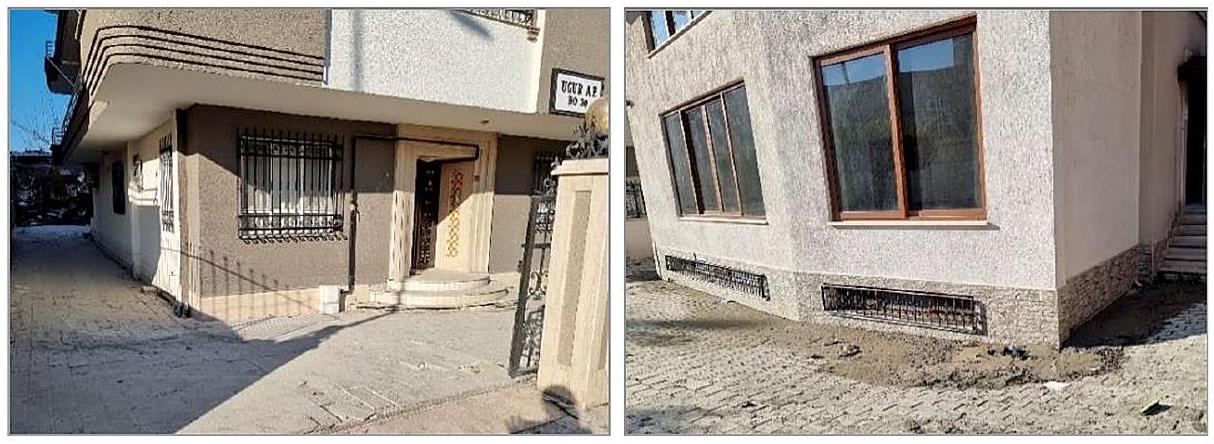
Soil liquefaction is defined as a significant loss of strength and stiffness due to the development of excess pore water pressures resulting in zero effective stress in the soil during a seismic event (Cetin and Ilgaç 2023). The soil liquefaction phenomena were predominantly observed in the İskenderun district of Hatay, affecting both existing structures and open areas. Some examples of observed liquefaction-induced sand ejecta surrounding the buildings in Iskenderun’s coastal part are presented in Fig. 4. The field investigations here have shown that the liquefied sand reached out of the surface, especially from the corners and edges of buildings. The structures have made a uniform settlement between 30 and 50 cm but have maintained their functions.
Fig. 4 Uniform settlement of a building (left) and sand ejecta around a structure (right) in Iskenderun coastal region of Hatay
Fig. 5 Sand cones and crater geometries along the coastline (left) and some of the damages on road structures (right) in Iskenderun district of Hatay
Moreover, towards the coastline, commonly, liquefaction and sand cones phenomena in open areas were observed. An example of the sand cones and ejecta can be seen in Fig. 5. Considering the number and volume of the cones, it has been determined that the liquefaction has spread over a wide area here. As a result of that widespread liquefaction occurred in this region; a large amount of water reached out of the ground surface with the liquefied sand. This also caused floods on the coastline, especially along Atatürk Boulevard. Excessive deformations in road structures due to settlements and sand ejecta also became a striking point of the observations (see Fig. 5).
Soil liquefaction phenomena were also observed in Antakya (Demirköprü), Arsuz, Kırıkhan and Dörtyol districts of Hatay. Lateral spreading, observed on the coastal part of Dörtyol district, is given in Fig. 6a. Sand ejecta were observed in the free-field here (Fig. 6b) as a result of lateral spreading caused by liquefaction. As a result of this spread, a failure surface of approximately 900 m length was formed. It was determined that the buildings in the western part of Dörtyol
Fig. 6 Liquefaction-induced failures observed in Dörtyol district of Hatay
Fig. 7 Landslide damage observed in Antakya (left) and in Altınözü (right) districts of Hatay
district were exposed to about 80 cm vertical settlements in addition to the lateral deformations. Some apparent examples of these deformations can be seen in Fig. 6c, d.
Apart from liquefaction, geotechnical damages were also detected in Antakya city center. The first of these was the small-scale slides in the Asi River, which passes through the middle of the city center. Another damage is the large-scale landslide that occurred in Altınözü, approximately 200 m long and 400 m wide. It has been observed that weak sedimentary rocks dominate at the base of the landslide area. The mentioned damages are shown in Fig. 7.
Liquefaction-induced geotechnical damage was also observed in Gölbaşı district of Adiyaman, consisting of quaternary alluvial plains. The region generally has two young units: alluvium and marsh sediments. Alluvium consists of greenish-light brown, brown-colored gravel, sand, and clay layers and occasionally contains silt bands. Gravel and sand units are also variably stratified in lateral and vertical directions. The swamp sediments are located around Gölbașı lake, west of Gölbaşı city center. They generally consist of black, dark brownish, dark grayish colored very fine silt and mud-sized sediments and contain abundant organic matter. Since the groundwater level in these areas is at or close to the surface, it mixes with clayey and silty levels, giving the ground a swamp-sludge feature (Akıl et al. 2008).
Lastly, during the Kahramanmaraş earthquakes, widespread soil problems were observed in the Gölbaşı area. Many buildings have faced issues such as excessive settlement, tilting and toppling over, etc. These problems are thought to arise from the poor earthquake per-
Fig. 8 Sand ejecta (left) and an overturned building (right) in Gölbaşı district of Adıyaman
formance of young alluvial soils with a high groundwater level. Additionally, the presence of sand ejecta in the free-field was also determined, as presented in Fig. 8. A building, near the close vicinity to this sand ejecta, was toppled over along the short side of the foundation. This indicates that liquefaction phenomena have caused many soil problems in Gölbaşı. The low depth of the foundation and the high length-to-width ratio of the building were also determined to facilitate the toppling. Consequently, it has been deduced that similar to past earthquakes, the necessity of considering the soil characteristics in the infrastructure design and construction has emerged again after the recent Kahramanmaraş earthquakes to ensure the safety of the infrastructures to be built in earthquake zones.
5 Seismic response of cast-in-place reinforced concrete structures
Most reinforced concrete (RC) structures have been built as cast-in-place in the region, including low and mid-story residential apartments and office buildings. Their story numbers range from 1 to 15 . Some buildings designed for the residential occupancy class have commercial spaces on their ground floors with a higher story height than the upper stories. Some of them have mezzanine stories as well. The load-bearing system of the majority of them was constituted with moment-resisting frames. Some of them also include shear walls. Most of the RC buildings in the region were constructed before 2000 without having sufficient engineering services. Therefore, many of them were severely damaged and collapsed during the earthquakes. The leading causes observed in severely damaged or collapsed buildings are poor material quality, soft story effect, strong beam-weak column behavior, large and heavy overhangs, insufficient beam-column joints, unconfined infill, gable walls, etc. Some of them are explained in detail in this section.
The residential buildings have been generally built within the development and update process of the Turkish Earthquake Code in 1967, 1975, 1998, and 2018. The 1998 code is a specification in which the concept of ductility, column-beam connection design, and strong column-weak beam design are discussed for the first time in Türkiye regarding earthquakeresistant structures. As a result of the site investigations within the scope of this regulation, it has been observed that the columns have weak sections compared to the beams and that designs are unsuitable for the strong column-weak beam princible in most residential build-
Fig. 9 Examples of plastic hinges at the bottom of columns (a), flexure cracks in beams (b), and damage in stair landings (c)
ings throughout the region. That caused the formation of plastic hinges at the upper and lower ends of the columns.
The general building stock has been observed to consist of frame systems with low aspect ratios. While this reduces the seismic force on the structure, it also causes structures to behave flexibly and have larger periods. In fact, in the field surveys conducted throughout the region, column joints at the ground floor foundation or basement walls have caused hinges even in new buildings. Due to the large displacements, it has been observed that concrete was crushed, and reinforcement was buckled or ruptured in the areas where hinges occurred. In buildings with rigid ground floors, hinges have been observed at the endpoints of the ground-floor columns (Fig. 9a). Flexure and shear cracks caused by seismic forces have also been observed in beams (Fig. 9b). Damage has been observed in beams due to torsion and stair landings due to the torsion effect (Fig. 9c).
5.1 Poor concrete quality and wrong placement of concrete
The quality of concrete is one of the most essential parameters in structural performance. Therefore, the minimum concrete quality used in the buildings has been defined as 18 MPa in the 1975 code, 20 MPa in the 1998 and 2007 codes, and 25 MPa in the Turkish Buildings Earthquake Code 2018. However, despite the presence of limit values for concrete quality in the regulations, an examination of concrete samples obtained from structures damaged during earthquakes has revealed that the concrete quality is far below the limits defined in the specifications. The reasons for this include the lack of appropriate mixing ratio, absence of suitable aggregate gradation (large-sized and smooth-surfaced aggregate), lack of vibration, segregation, and presence of foreign materials in the concrete (such as plastic, paper, wood, etc.). Field observations have identified certain drawbacks directly affecting concrete quality, such as inappropriate aggregate sizes, segregation, and the presence of foreign materials.
Most buildings constructed before 2000 were built using man-made concrete mixed and manufactured by human labor. Therefore, they have common mistakes such as wrong concrete mix (wrong water, cement, and aggregate ratio), low cement ratio, the existence of organic and inorganic materials in the mix, very small or massive aggregate, wrong placement of concrete (heavy segregation), etc. some examples of poor concrete quality and segregation are depicted in Fig. 10.
Fig. 10 Examples of poor concrete quality (a) and wrong placement of concrete (segregation) (b)
5.2 Poor reinforcing steel quality, corrosion, and improper placement of reinforcement
The bonding between the concrete and the reinforcement must be established for reinforced concrete structural elements to exhibit the expected ductile behavior. The bonding between concrete and reinforcement is a crucial parameter that enables these two materials to work together. Ribbed reinforcements are produced by creating notches on the surface of the reinforcement to increase bonding. However, while the use of ribbed reinforcement was not mandatory in the past, it became compulsory in 1998 in the Turkish Earthquake Code. Until then, smooth reinforcement and poor-quality concrete have resulted in reinforced concrete structures with weak bonds (Olabi et al. 2022). Some of these structures have also been found to have corrosion on reinforcement. Due to the corrosion-induced section loss in the reinforcement, bonding weakens, and the load-bearing capacity of RC members decreases (Less et al. 2023). Additionally, non-compliant practices with regulatory details have been observed in the placement of transverse reinforcements (stirrups) in structural elements, such as inadequate, irregular, hookless, and excessive spacing. As in previous earthquakes, inadequate, poor-quality, smooth reinforcement, reinforcement corrosion, and poor workmanship in reinforcement and concrete have caused significant damage to reinforced concrete structures during the 2023 Kahramanmaraş earthquakes.
Additionally, it has been observed that plain reinforcing steel was generally used in buildings constructed before 2000. The reinforcement steel also had significant corrosion due to insufficient concrete cover (Fig. 11a). Concrete segregation has also been detected in these buildings (Fig. 11b). In many buildings, stirrups were bent wrongly at 90 -degree instead of 135-degree, as prescribed in the TBEC 2018 (Fig. 11c). In many buildings in the region, it was observed that the protruding reinforcement bars of columns and walls from the foundation did not comply with the overlapping length requirement specified in the regulations. In these areas, due to the lack of proper spacing between reinforcement bars and the bending of reinforcing bars at 90 -degree angles, plastic hinges have formed at the bottom of the columns, causing concrete cracking and reinforcement deformation.
Fig. 11 Unribbed smooth reinforcement and heavy corrosion (a), insufficient concrete cover and heavy segregation (b), and wrongly bent stirrups (90-degree bent) (c)
5.3 Soft story effects in ribbed slab constructions
The heavily damaged and collapsed reinforced concrete buildings, which were generally constructed after 2000 years in the densely populated settlements such as Nurdağı, İslahiye, Pazarcık, Türkoğlu, Kırıkhan, and Antakya, are examined closely in the post-earthquake region. Notably, they have similar architectural features and were arranged with the same type of load-bearing system, especially for the floor members. As can be seen from Figs. 12 and 13, the first two floors of such multi-story buildings have been designed for commercial workplace purposes, and the floors above them are used as residential areas with large and heavy overhangs. It has been observed in the field that these types of apartment buildings with similar engineering and architectural design errors failed against seismic forces.
Moreover, examining the building stocks in the earthquake-hit regions, one-way ribbed slabs have generally been widely used in the load-bearing systems of five- to eight-story buildings. It is remarkable to note that the vertical structural elements carrying these types of floor slabs have not been supported by shear walls as clearly specified in the TBEC (2018). Many residential structures having ribbed slab systems (using lightweight briquette blocks or styrofoam between floor joists) were severely damaged due to inadequate shear
Fig. 12 Collapse mechanism due to soft story effect: P -delta effects with additional vertical inertial forces
Fig. 13 Examples of typical buildings in the earthquake-hit region and heavy structural damages due to engineering and architectural design errors
resistance because they could not exhibit rigid diaphragm behavior. Apparently, the ribbed slab applications in RC structures that are incompatible with the restrictions imposed on such beamless plates in the earthquake codes have caused heavy damage or destruction triggered by the soft story effect. The seismic energy transmitted to the structure was not consumed as required at the beam ends in line with the strong column-weak beam principle. On the contrary, the energy consumption points resulted in the formation of plastic hinges at the whole column ends of the ground floor in the immediate initial vibrations of the earthquake ground motion, making the structure unable to bear the seismic shear forces. Ultimately, it can be clearly seen in Fig. 12 that the upper residential floors of such buildings become unusable by making a rigid movement compared to the lower-story floors without shaking during the vibration period.
It should also be noted that the vertical accelerations generated by the 2023 Kahramanmaraş earthquakes were as effective as the horizontal acceleration components. Therefore, especially the buildings designed with ribbed floor slabs were subjected to significant seismic forces. In this case, ribbed slab construction leads to additional axial loads on vertical structural members as they cannot show sufficient resistance against high vertical accelerations like conventional two-way beam-supported slabs. While the moments of bearing capacity at the ground floor columns decreased drastically with the increase of the axial load, the second-moment effects emerged because of the earthquake’s excessive displacement demand on these floors, and the design moment on these load-bearing elements increased significantly (Fig. 12). As shown in Fig. 13, the stability of individual column members on the ground floor was influenced adversely by the increased number of plastic hinges triggering the collapse mechanism of soft story action due to the demand of undesired large story drift depending on the additional vertical inertia forces.
The lateral load-bearing systems with a high ductility level proposed for ribbed floor slabs in the earthquake-affected areas have generally not been designed per the Turkish Earthquake Codes involving special design provisions to avoid soft story effects. As a result of modeling the floor as a rigid diaphragm in computer-aided structural analysis, it is determined that the earthquake loads cannot be fully transferred to the vertical elements properly. Turkish Building Earthquake Code considers the load-bearing systems of buildings with ribbed floor slabs not supported by shear walls as having limited ductility. However, it also allows the construction of such buildings in regions with low seismicity. In other words, it doubles seismic loads for the structural design of ribbed floor constructions compared to two-way slab systems.
5.4 Strong beam and weak column behavior
During earthquakes, column-beam joint regions are subjected to significant forces. If these forces exceed the strength of the column and beam, plastic hinges are formed in these regions. In order to prevent sudden and brittle failure, it is desired to have these plastic hinges form at the ends of the beams rather than at the ends of the columns. That ensures the principle of the strong column and weak beam behavior, as defined in the seismic design codes. Furthermore, to ensure sufficient rigidity in these regions, transverse reinforcement along the confinement zone should be densified according to the criteria specified in the specifications. However, field investigations have revealed that the practices mentioned earlier were not adequately implemented, significantly damaging the structures.
Additionally, the 1998 Turkish Earthquake Code is the first in Türkiye to address the concept of ductility for designing structures that will not collapse in earthquakes, as well as the design of column-beam joint regions and strong column-weak beam design. As a result of field surveys conducted under this regulation, it has been observed that in buildings constructed before 1998, columns have weaker cross-sections compared to beams. Most residential buildings in the region have not been designed to comply with the strong col-umn-weak beam principle. Therefore, those buildings were severely damaged or collapsed during the Kahramanmaraş earthquakes. Lastly, the insufficient resistance of columns to beams has led to the formation of shear cracks and hinges at the top and bottom ends of the columns (Fig. 14).
5.5 Large and heavy overhangs
It is prescribed in many earthquake design codes that external eccentricities that may occur in terms of mass, stiffness, and strength can be prevented by arranging a symmetrical structural system. As a result, a predictable seismic behavior can be achieved. When the damaged and collapsed buildings in the region were observed, it was determined that many buildings
Fig. 14 Examples of a strong beam weak column design and damage on columns
Fig. 15 Examples of large and heavy overhangs on RC buildings in the earthquake-hit region
Fig. 16 Examples of column damage due to large overhangs (a) and a building collapse due to additional floors (b)
specifically located on main streets had extensive overhangs extending to 1.5 m . Moreover, the columns carrying those overhangs were not connected with the beams, and that caused the formation of an insufficient tied framing system. Therefore, the columns could not work together or provide proper load transfer (Fig. 15). Moreover, in earthquake-resistant building design, placing shear walls that can withstand a significant portion of the earthquake forces is important. In the region, even if shear walls were included in the buildings, it was observed that they were not symmetrically placed in structures. The resulting irregularity in torsion and the additional moment effects caused by the heavy overhangs resulted in the formation of plastic hinges at the end regions of all columns in the outer axis (Fig. 16a).
Additionally, one of the most essential structural problems observed in the areas affected by earthquakes is that existing buildings have been completed by the addition of new floors on the structures over the years without having any engineering services. During the construction of these additional floors, the load-bearing system of the existing floor, vertical element continuity in the new floors, cold joints between floors, construction techniques, and material differences were not considered. For example, the building in Fig. 16b was initially built as a single-story masonry ground floor. Over the years, a three-story RC structure was
Fig. 17 An example of a column connecting on the end of cantilever beams (the right drawing from TBEC 2018)
added, and finally, it was completed with a steel frame roof floor. While the original ground floor remained standing, the additional stories built on top collapsed during the earthquakes.
Lastly, many seismic codes never allow the placement of columns on the top or end of cantilever beams or on the gussets formed on the lower columns of any building floor. However, during the field surveys, plastic hinge occurrences have been observed in some buildings due to reinforcement bending and concrete pouring at the bottom of columns as a result of that practice (Fig. 17).
6 Seismic response of precast concrete structures
Prefabricated structures built with precast reinforced concrete elements are used as production areas in industry. The components of such construction systems are produced in a factory environment in a controlled manner. Faster and controlled assembly of structural members in the field saves time and cost. Structural elements produced by this method are ahead of traditional construction techniques with their strength and dimensional stability. The production is based mainly on agriculture and animal husbandry, textile, metal and steel industry, paper industry, food production, and agricultural machinery production in the earthquake-hit region are made in such structures.
After the 2023 Kahramanmaraş earthquakes, a field investigation was conducted on the precast structures in and around Kahramanmaraş province, and the damage patterns were observed on those structures. The most common type of damage was the falling of the horizontal beams resting on the column corbels by disconnecting their joints. Similarly, damage to the ends of roof purlins that were not adequately connected to the beams and falling of them to the ground was common (Fig. 18). The damage was generally caused by the inability of the structural elements to respond to the seismic displacement and rotation demands in joint regions, the weakness of the members in the joints, and pin connections that are not filled with cement mortar. Due to the lack of connection details, the precast floor elements sitting on the beams also separated from
Fig. 18 Examples of insufficient fastening of roof purlins to beams (a), and damage in joint regions (b)
Fig. 19 Floor damage due to poor connection detailing (left) and a precast concrete structure with weak columns and heavy roof beams (right)
the connection points, disrupting the integrity of the building and could not show the diaphragm behavior supposed to be provided at floor levels (Fig. 18).
The architectural and structural system plans, which were arranged incorrectly, revealed the effects of torsion and caused the beams to be separated from the columns. For example, a 5-meter-high mezzanine floor was built in a part of a reinforced concrete precast building with a floor height of 10 m (see Fig. 19). In these two regions, the damage occurred due to the simultaneous rigid and flexible behavior that differs depending on the column lengths and the mezzanine diaphragm. Moreover, severe damage and collapses were widely observed in prefabricated structures with weak columns and heavy roof beams that could not provide horizontal stability (Fig. 19).
Additionally, infill wall damage in prefabricated buildings was also widespread. Lowstrength, hollow briquettes, commonly called “bims” have been widely used in the structures located in the region. Due to low horizontal reinforced concrete beams providing stability in large-span walls and exceeding the maximum unsupported wall length, the out-of-plane movement occurred in the walls during the Kahramanmaraş earthquakes (Fig. 20). Moreover, the panels coming out of the slots supported on the columns or out-of-plane movement were one of the common and typical damages seen in the precast wall panels (Fig. 20). Failure to perform the necessary precision quality to the joints during the production and assembly stages, filling the pins with low-strength cement mortar or not filling them at all, and insufficient or no use of nuts, washers, and welds caused significant damage on precast wall panels. Lastly, bending cracks at the lower end of the columns, separation of the shell
Fig. 20 Examples of large-span walls exceeding the maximum unsupported wall length on the walls (left) and out-of-plane tipping damage on the precast wall panels (right)
concrete, buckling of the reinforcements, and damage up to the rupture of the reinforcement were also observed in the column-foundation nodes.
7 Seismic response of masonry structures
Historical monumental structures are the most valuable treasures that reflect the history of societies and nations and reveal their culture and civilization. Such structures are carefully preserved worldwide, as they show the levels and lifestyles of communities in culture and art, which connects societies’ past to the future. The masonry construction technique is used all over the world for the construction of low and medium-rise buildings. Wood, adobe, brick, and stone are the oldest known building materials. These materials are still used today because of their cost-effectiveness, durability, local availability, and sound-insulating properties. Earthquake codes have been updated many times for the design and construction of such structures (Günaydin et al. 2021).
The data obtained from field surveys after the Kahramanmaraş earthquakes showed a significant fragility in the masonry building stock constructed using traditional methods and materials. Most of the buildings in the region have been built in the form of arched, vaulted, and domed structures with baked clay bricks, rubble stone, or cut stone masonry. Most buildings are unreinforced masonry structures characterized by rubble stone walls with two smooth surfaces connected. In some buildings, the diaphragms between the floors have been constructed with wood, steel, and brick materials using masonry. In addition to residences, public buildings, and factories in the region, Kahramanmaraş earthquakes also affected historical structures. They caused significant damage and collapse, specifically in Hatay, Adiyaman, Kahramanmaraş, and Gaziantep provinces. of historical buildings in the region were destroyed or severely damaged. Macro seismic scale earthquake damages of magnitude IX-XI occurred in Antakya and Kahramanmaraş (KOERI, 2023). Excessive ground motion demand in peak ground acceleration further increased the damage to structures damaged by previous shocks.
More than half of the buildings collapsed in the historical city center of Hatay. Among them, Habib-i Neccar Mosque, Sarımiye Mosque, Historical Saints Peter and Paul Church, Greek Orthodox Church, and Iskenderun Italian Latin Catholic Church are essential struc-
Fig. 21 Habibi Neccar Mosque, Antakya, Hatay, before (left) and after (right) the Kahramanmaraş earthquakes
Fig. 22 Sarimiye Mosque, Antakya, Hatay, before (a) and after (b) the Kahramanmaraş earthquakes
tures of our historical architectural heritage that were partially damaged or collapsed in the historical city center of Hatay. Those structures’ pre- and post-earthquake situations are depicted throughout Figs. 21, 22, 23 and 24, respectively.
Moreover, the investigated historical buildings in Gaziantep, built mainly between the 17th century and the end of the 19th century, performed better seismic response due to being far from the fault line. Restored historical building examples showing good performance in the historical center of Gaziantep province were examined. Since these structures are relatively far from the fault line, the structures were exited with accelerations smaller than the design earthquake level of TBEC 2018. In the historical buildings inspected in Gaziantep province, slip cracks in the main walls, openings in the joints, and local separations in the outer layers of the walls were observed (see Fig. 25). There was damage to the joints of arches and vaults, and out-of-plane movements were detected at the wall-vault joints (Fig. 26). Opening at the joints, vertical cracks, and overturning on the pedestals were observed in the mosque’s minarets (Fig. 27).
Many factors have contributed to the collapse response of masonry structures during the 2023 Kahramanmaraş earthquakes. One of the most important factors is the characteristics and direction of the earthquake (directivity effect). This effect is more complex for historical buildings having different building elements with varying geometries. Establishing effective connections between horizontal slabs and vertical load-bearing walls provides
Fig. 23 The Historical Church of Saints Peter and Paul, Antakya, Hatay, before (left) and after (right) the Kahramanmaraş earthquakes
Fig. 24 Antakya Greek Orthodox Church (left) and Iskenderun Italian Latin Catholic Church (right) after the Kahramanmaraş earthquakes
Fig. 25 Examples of damage to the structural main walls
the structures with a box-like structural behavior, prevents external façades from falling over during earthquakes, and increases earthquake performance. It has been observed in the region that horizontal diaphragms prevented the out-of-plane falling mechanism of the facade walls. Moreover, the use of steel tensioners in the masonry construction technique contributed to preventing wall collapses. As a result, since most of the architectural heritage masonry buildings are still in use in the region and Türkiye, it should be noted that they are susceptible to seismic effects due to their both high specific mass and low tensile strength.
Fig. 26 Examples of tensile cracks at joints in arches, vaults, and domes, out-of-plane movements
Fig. 27 Examples of damage to minarets
Consequently, the damage to the masonry buildings in the region occurred in the form of shear failure, opening in the joints, out-of-plane movement and overturning due to the weakness of the building elements and mortar quality, weak tension connections, weak floor diaphragms, and non-compliance with the construction rules in wall joints. In most damaged masonry structures, poor connection between structural members and wall layers, irregular structure, and weak and deteriorated materials were observed. The out-of-plane collapse of the main walls generally occurred either due to the failure of the material’s compressive strength or by the wall layer’s separation or slippage. Another form of damage observed after cracking is that the walls split and fell out of the plane in blocks. However, it has been observed that masonry buildings with good seismic performance in the examined region have the following characteristics: (i) A well-arranged connection between the walls or between the wall and the diaphragm provides an effective box behavior, (ii) The transverse connection between the wall layers is ensured properly, (iii) Masonry units have a regular shape and arrangement, and (iv) The mechanical properties of the building units and the mortar are very good.
8 Conclusions
This study has comprehensively assessed the geotechnical and structural aspects following the 2023 Kahramanmaraş earthquakes. The research conducted by a team of experts has yielded valuable insights into the performance of the built environment, considering factors such as structural damage, local site conditions, and strong ground motion data. The key findings of this investigation are summarized as follows:
The vulnerability of settlements in Antakya district of Hatay, Türkoğlu district of Kahramanmaraş, and Gölbaşı district of Adıyaman, characterized by a high incidence of demolitions and structural damages, is attributed to their locations on alluvial deposits surrounding the Amik Plain. These areas, fed by old lake beds and the Asi River, exhibit significant amplification of seismic ground motion amplitudes due to soft soil conditions. Failure to implement earthquake-resistant foundation designs for problematic soils, as recommended in geotechnical survey reports, has led to many collapsed buildings, resulting in loss of life and property. Despite their distance from the earthquake epicenter, settlements like Hatay/Kırıkhan and Gaziantep/İslahiye have experienced a heightened impact on building collapses and severe damage due to their proximity to fault lines.
The vertical component of ground motion produced by the earthquake along the Eastern Anatolian fault has been as influential as the horizontal component. That has exacerbated the soft-story problem in multi-story residential buildings with cantilevered slab floors, ultimately leading to building collapses or rendering them unusable.
Severe damage or collapse in reinforced concrete buildings is primarily attributed to factors such as poor material quality, the soft-story effect, strong column-weak beam behavior, oversized and heavy overhangs, insufficient beam-column joints, and unconfined infill and gable walls.
Widespread damage in precast structures was characterized by the detachment of horizontal beams from column corbels, inadequate connections leading to roof purlin collapses, and compromised structural integrity due to poor joint responses and pin connections. Architectural and structural arrangement errors introduced torsional effects, separating beams from columns, while severe damage and collapses were common in structures with weak columns and heavy roof beams. Infill wall issues were also prevalent, attributed to low-strength materials and a lack of horizontal reinforcement. Lastly, column-foundation nodes exhibited various structural problems, including bending cracks, shell concrete separation, reinforcement buckling, and damage to reinforcement integrity.
Historical buildings in the region, constructed with shorter vibration periods on more favorable soil conditions, have experienced more extensive damage when compared to largeperiod reinforced concrete structures. This phenomenon is ascribed to the presence of larger horizontal and vertical spectral accelerations, which depend on the vibration period and construction techniques. Damage to masonry buildings in the area has materialized as shear failures, joint openings, out-of-plane movements, and overturning, primarily attributable to structural element weaknesses, mortar quality deficiencies, inadequately strong tension connections, weak floor diaphragms, and non-compliance with construction standards in wall joints.
Appendix A
Figs. A1 and A2.
Fig. A1 Pazarcık (Kahramanmaraş) Earthquake ( ), Station 4614 (Kahramanmaraş/Pazarcık), Acceleration vs. Arias Intensity, Velocity and Displacement time histories ( , Soil class: ZC)
Fig. A2 Elbistan (Kahramanmaraş) Earthquake ( ), Station 4406 (Malatya/Akçadağ), Acceleration vs. Arias Intensity, Velocity and Displacement time histories ( , Soil class: ZB)
Acknowledgements The authors would like to acknowledge sincere thanks to The Scientific and Technological Research Council of Türkiye (TÜBİTAK), for supporting and funding the site investigations with 1002-C Natural Disasters – Focused Fieldwork Emergency Investigation program.
Author contributions All authors contributed to the study equally. All authors read and approved the final manuscript.
Funding Open access funding provided by the Scientific and Technological Research Council of Türkiye (TÜBİTAK). The authors would like to acknowledge The Scientific and Technological Research Council of Türkiye (TÜBİTAK), for supporting and funding the site investigations with 1002-C Natural Disasters Focused Fieldwork Emergency Investigation program.
Declarations
Competing Interests The authors have no relevant financial or non-financial interests to disclose.
Open Access This article is licensed under a Creative Commons Attribution 4.0 International License, which permits use, sharing, adaptation, distribution and reproduction in any medium or format, as long as you give appropriate credit to the original author(s) and the source, provide a link to the Creative Commons licence, and indicate if changes were made. The images or other third party material in this article are included in the article’s Creative Commons licence, unless indicated otherwise in a credit line to the material. If material is not included in the article’s Creative Commons licence and your intended use is not permitted by statutory regulation or exceeds the permitted use, you will need to obtain permission directly from the copyright holder. To view a copy of this licence, visit http://creativecommons.org/licenses/by/4.0/.
Akıl B, Akpınar K, Üçkardeşler C, Araz H, Sağlam M, Uran ŞB (2008) Doğu Anadolu Fay Zonu Üzerinde Yer Alan Gölbaşı (Adıyaman) Yerleşim Alanındaki Zeminlerin Jeoteknik Özellikleri ve Değerlendirilmesi/ Evaluation of settlement suitability of Gölbaşı (Adıyaman) Town, located on the East Anatolian Fault Zone. Türkiye Jeoloji Bülteni 51(1):43-57
Ambraseys NN (1989) Temporary seismic quiescence: SE Turkey. Geophys J Int 96:311-331. https://doi.or g/10.1111/j.1365-246X.1989.tb04453.x
Barka AA, Kadinsky-Cade K (1988) Strike-slip fault geometry in Turkey and its influence on earthquake activity. Tectonics 7:663-684. https://doi.org/10.1029/TC007i003p00663
Barka A, Reilinger R (1997) Active tectonics of the Eastern Mediterranean region: deduced from GPS, neotectonic and seismicity data. 3
Bulut F, Bohnhoff M, Eken T et al (2012) The East Anatolian Fault Zone: seismotectonic setting and spatiotemporal characteristics of seismicity based on precise earthquake locations. J Geophys Res Solid Earth 117. https://doi.org/10.1029/2011JB008966
Cetin K, Ilgaç M (2023) Reconnaissance Report on February 6, 2023 Kahramanmaraş-Pazarcık (Mw=7.7) and Elbistan (Mw=7.6) Earthquakes. https://doi.org/10.13140/RG.2.2.15569.61283/1
Demir A (2022) Progressive collapse resistance of low and mid-rise RC mercantile buildings subjected to a column failure. Struct Eng Mech 83(4):563-576. https://doi.org/10.12989/sem.2022.83.4.563
Duman TY, Emre Ö (2013) The East Anatolian Fault: geometry, segmentation and jog characteristics. Geol Soc 372:495-529. https://doi.org/10.1144/SP372.14
Emre Ö, Duman T, Özalp S et al (2013) Active Fault Map of Turkey with an Explanatory Text. 1:1,250,000 Scale
Garini E, Gazetas G, Anastasopoulos I (2017) Evidence of significant forward rupture directivity aggravated by soil response in an M w 6 earthquake and the effects on monuments. Earthq Eng Struct Dyn 46:2103-2120. https://doi.org/10.1002/eqe. 2895
Günaydin M, Atmaca B, Demir S et al (2021) Seismic damage assessment of masonry buildings in Elazığ and Malatya following the 2020 Elazığ-Sivrice earthquake, Turkey. Bull Earthq Eng 19:2421-2456. ht tps://doi.org/10.1007/s10518-021-01073-5
ITU (2023) 6 Şubat Kahramanmaraş (Pazarcık, Türkoğlu), Hatay (Kırıkhan), ve 13.24 Mw 7,7 Kahramanmaraş (Elbistan/Nurhak-Çardak) Depremleri Ön İnceleme Raporu (in Turkish), Istanbul Technical University. https://haberler.itu.edu.tr/docs/default-source/default-document-library/ 2023_itu_deprem_on_raporu.pdf. Accessed 1 November 2023
Karabacak V, Özkaymak Ç, Sözbilir H et al (2023) The 2023 Pazarcık (Kahramanmaraş, Türkiye) Earthquake (Mw: 7.7): implications for surface rupture dynamics along the East Anatolian Fault Zone
KOERI, Earthquake Research Institute Department of Earthquake Engineering (2023) Strong Ground Motion and Building Damage Estimations Preliminary Report (v6), Boğaziçi University Kandilli Observatory and. https://eqe.bogazici.edu.tr/sites/eqe.boun.edu.tr/files/kahramanmaras-gaziantep_earthquake_06-0 2-2023_04.17-bogazici_university_earthquake_engineering_department_v6.pdf. Accessed 1 November 2023
Less T, Demir A, Sezen H (2023) Structural performance and corrosion resistance of fiber reinforced polymer wrapped steel reinforcing bars. Constr Build Mater 366:130176. https://doi.org/10.1016/j.conbuildma t.2022.130176
McClusky S, Balassanian S, Barka A et al (2000) Global positioning system constraints on plate kinematics and dynamics in the eastern Mediterranean and Caucasus. J Geophys Res Solid Earth 105:5695-5719. https://doi.org/10.1029/1999JB900351
McKenzie D (1972) Active tectonics of the Mediterranean Region. Geophys J Int 30:109-185. https://doi.or g/10.1111/j.1365-246X.1972.tb02351.x
Nalbant SS, McCloskey J, Steacy S, Barka AA (2002) Stress accumulation and increased seismic risk in eastern Turkey. Earth Planet Sci Lett 195:291-298. https://doi.org/10.1016/S0012-821X(01)00592-1
Olabi MN, Caglar N, Arslan ME et al (2022) Response of nonconforming RC shear walls with smooth bars under quasi-static cyclic loading. Bull Earthq Eng 20:6683-6704. https://doi.org/10.1007/s10518-02 2-01451-7
PSBD (2023) 2023 Kahramanmaraş and Hatay Earthquakes Report (in Turkish), Presidential Strategy and Budget Directorate. https://www.sbb.gov.tr/wp-content/uploads/2023/03/2023-Kahramanmaras-and-H atay-Earthquakes-Report.pdf. Accessed 1 November 2023
Reilinger R, McClusky S, Vernant P et al (2006) GPS constraints on continental deformation in the Africa-Arabia-Eurasia continental collision zone and implications for the dynamics of plate interactions. J Geophys Res Solid Earth 111. https://doi.org/10.1029/2005JB004051
Sagbas G, Garjan RS, Sarikaya K, Deniz D (2023) Field reconnaissance on seismic performance and functionality of Turkish industrial facilities affected by the 2023 Kahramanmaras earthquake sequence. Bull Earthq Eng. https://doi.org/10.1007/s10518-023-01741-8
Şengör AMC, Yilmaz Y (1981) Tethyan evolution of Turkey: a plate tectonic approach. Tectonophysics 75:181-241. https://doi.org/10.1016/0040-1951(81)90275-4
Şengör AMC, Görür N, Şaroğlu F (1985) Strike-Slip Faulting and Related Basin Formation in Zones of Tectonic Escape: Turkey as a Case Study. In: Strike-Slip Deformation, Basin Formation, and Sedimentation. SEPM (Society for Sedimentary Geology) 211-226
TADAS (2023) Turkish Accelerometric Database and Analysis System. Disaster and Emergency Presidency of Türkiye (AFAD), www.tadas.afad.gov.tr. Accessed 1 November 2023
Tan O, Pabuçcu Z, Tapırdamaz MC et al (2011) Aftershock study and seismotectonic implications of the 8 March 2010 Kovancılar (Elazığ, Turkey) earthquake (mw=6.1). Geophys Res Lett 38:L11304. https:// doi.org/10.1029/2011GL047702
Taymaz T, Eyidoğan H, Jackson J (1991) Source parameters of large earthquakes in the East Anatolian Fault Zone (Turkey). Geophys J Int 106:537-550. https://doi.org/10.1111/j.1365-246X.1991.tb06328.x
TBEC (2018) Turkish building Earthquake Code. Turkish Ministry of Environment and Urbanization, Ankara, Türkiye
Utkucu M, Budakoğlu E, Çabuk M (2018) Teleseismic finite-fault inversion of two earthquakes along the East Anatolian Fault Zone in Turkey: the 1998 Adana and 2003 Bingöl earthquakes. Arab J Geosci 11:721. https://doi.org/10.1007/s12517-018-4089-y
Xu J, Liu C, Xiong X (2020) Source process of the 24 January 2020 mw 6.7 East Anatolian Fault Zone, Turkey, Earthquake. Seismol Res Lett 91:3120-3128. https://doi.org/10.1785/0220200124
Publisher’s Note Springer Nature remains neutral with regard to jurisdictional claims in published maps and institutional affiliations.
Authors and Affiliations
Aydin Demir (D) • Erkan Celebi Hakan Ozturk Zeki Ozcan Askin Ozocak Ertan Bol Sedat Sert F. Zehra Sahin Eylem Arslan Zeynep Dere Yaman Murat Utkucu Necati Mert
Aydin Demir aydindemir@sakarya.edu.tr
1 Department of Civil Engineering, Faculty of Engineering, Sakarya University, Sakarya 54050, Turkey
2 Department of Geophysical Engineering, Faculty of Engineering, Sakarya University, Sakarya 54050, Turkey
Extended author information available on the last page of the article