مجموعة بيانات النظائر المستقرة العالمية لمياه السطح Global Stable Isotope Dataset for Surface Water

المجلة: Earth system science data، المجلد: 17، العدد: 5
DOI: https://doi.org/10.5194/essd-17-2135-2025
تاريخ النشر: 2025-05-21

مجموعة بيانات النظائر المستقرة العالمية لمياه السطح

روي لي قوفينغ زو لونغهو تشين شياويو تشي سيو لو قو جيا مينغ يوهاو وانغ وينمن لي تشنغ زهيجي جيانغ وي يانغ ، وياني غون كلية الجغرافيا وعلوم البيئة، جامعة نورمال الشمالية، لانزهو 730070، قانسو، الصين محطة مراقبة البيئة الإيكولوجية لنهر شيانغ، جامعة نورمال الشمالية الغربية، لانزهو 730070، قانسو، الصين المختبر الرئيسي لبيئة الموارد والتنمية المستدامة للواحات، مقاطعة قانسو، لانزهو 730070، قانسو، الصينالمراسلة: قوفينغ زو (zhugf@nwnu.edu.cn)

تاريخ الاستلام: 16 يوليو 2024 – بدأت المناقشة: 13 أغسطس 2024
تمت المراجعة: 9 ديسمبر 2024 – تم القبول: 5 مارس 2025 – تم النشر: 21 مايو 2025

الملخص

تُستخدم النظائر المستقرة للهيدروجين والأكسجين على نطاق واسع كعلامات لدورة المياه، وتُعتبر المياه السطحية جزءًا لا يتجزأ من دورة المياه. مقارنةً بالمسطحات المائية الأخرى، تكون المياه السطحية أكثر عرضة لعوامل طبيعية وبشرية مختلفة، وفهم التغيرات في المياه السطحية بدقة له أهمية كبيرة في ضمان الأمن المائي الإقليمي، والحفاظ على التوازن البيئي، وتعزيز التنمية الاقتصادية والاجتماعية المستدامة. التوزيعات المكانية والزمنية لبيانات النظائر المستقرة للمياه السطحية العالمية غير متساوية للغاية على المستوى العالمي بسبب عوامل مثل ظروف المراقبة والتحليل بالأدوات. لهذا السبب، قمنا بتجميع وتحليل بيانات النظائر المستقرة للهيدروجين والأكسجين في المياه السطحية من 22389 محطة أخذ عينات حول العالم من عام 1956 إلى 2023، مع 102511 سجل بيانات. تشير النتائج إلى ما يلي: (1) تتناقص النظائر المستقرة للمياه السطحية العالمية تدريجياً من خط الاستواء إلى القطبين ومن الساحل إلى الداخل. ومع ذلك، هناك اختلافات كبيرة في التوزيعات المكانية والزمنية لنظائر المياه السطحية في مناطق مختلفة. (2) يتم التحكم في التغير في النظائر المستقرة في المياه السطحية من خلال الموقع الجغرافي، وظروف التضاريس، والعوامل المناخية (خاصة درجة الحرارة)، وتعتبر تباينها كبيرًا. توفر مجموعة بيانات النظائر المستقرة العالمية للمياه السطحية معلومات حيوية لفهم أعمق لدورة المياه وتغير المناخ. يمكن أن توفر مراجع بيانات أساسية لإدارة الموارد المائية العالمية والبحث. مجموعة بيانات النظائر المستقرة العالمية للمياه السطحية متاحة علىhttps://doi.org/10.17632/fs7rwp7fpr.2 (زو، 2024).

1 المقدمة

تعتبر الموارد المائية أساسًا ماديًا أساسيًا لبقاء الإنسان ولا غنى عنها للحفاظ على التنمية الاجتماعية والاقتصادية المحلية المستدامة، والحفاظ على الصحة البيئية واستقرار النظام البيئي (إيميرزيل وآخرون، 2020؛ ميهتا وآخرون، 2024). بسبب النشاط البشري وتغير المناخ، تغيرت الأنظمة الهيدرولوجية العالمية في العقود الأخيرة، مما زاد من الضعف البيئي والحساسية تجاه تغير المناخ (شاحين، 1992؛ ليو وآخرون، 2021؛ ساتوه وآخرون، 2022). تعتبر نظائر الهيدروجين والأكسجين، كنوع من النظائر المستقرة الموجودة على نطاق واسع في عمود الماء (ريكيرث وآخرون،
2017؛ Sprenger وآخرون، 2016)، هي عناصر مهمة لإجراء دراسات دورة المياه ولها دور دلالي أساسي في دراسة دورة المياه (Aggarwal وآخرون، 2007؛ Joussaume وآخرون، 1984؛ Vystavna وآخرون، 2021). ومع ذلك، بسبب القيود المفروضة من ظروفها في مناطق مختلفة من العالم، هناك عدد من الصعوبات والقيود في جمع ودمج وتحليل بيانات النظائر المستقرة الحالية لمياه السطح (Chen وآخرون، 2020؛ Penna وآخرون، 2018).
في عام 1960، تم إنشاء الشبكة العالمية لنظائر الهطول (GNIP) من قبل الوكالة الدولية للطاقة الذرية (IAEA) ومنظمة الأرصاد الجوية العالمية-
منظمة الأرصاد الجوية العالمية (WMO)، بهدف بناء شبكة مراقبة عالمية تركز على الدراسة المتعمقة لنظائر الهيدروجين والأكسجين في الأمطار (Aggarwal et al., 2012). مقارنةً بمراقبة النظائر المستقرة العالمية في الأمطار، فإن مراقبة المياه السطحية العالمية متأخرة. في عام 2002، بدأت الوكالة الدولية للطاقة الذرية (IAEA) في بناء الشبكة العالمية للنظائر في الأنهار (GNIR)، التي تهدف إلى دراسة التفاعلات بين المياه السطحية والمياه الجوفية باستخدام النظائر المستقرة في الجريان السطحي وتحديد آثار تغير المناخ على جريان الأنهار وآثار النشاط البشري على تباين الأنهار (Halder et al., 2015). درس العديد من الأكاديميين في جميع أنحاء العالم تركيب النظائر المستقرة في المياه السطحية. في جميع أنحاء العالم، حقق العلماء المشاركون في أبحاث النظائر المستقرة في المياه السطحية العديد من النتائج؛ على سبيل المثال، استخدم باحث بيانات النظائر المستقرة لمياه الأنهار الأمريكية لرسم توزيع النظائر لمياه الأنهار الأمريكية واستخدم النموذج لتحليل تغييرات نظائر مياه الأنهار الأمريكية (Bowen et al., 2011; Dutton et al., 2005). بالإضافة إلى ذلك، يتأثر تركيب النظائر المستقرة في المياه السطحية بمجموعة متنوعة من العمليات الهيدرولوجية مثل الأمطار، والتبخر، والجريان السطحي، وبالتالي يمكن أن توفر معلومات قيمة حول عمليات دورة المياه، وإدارة موارد المياه، وآثار تغير المناخ (Bowen et al., 2019; Darling, 2004; Schulte et al., 2011). يمكن فهم المصدر، والتدفق، والتراكم، وقاعدة التغيير للمياه السطحية بشكل شامل من خلال تحليل وتفسير بيانات النظائر المستقرة، مما يمكن أن يقدم أساسًا علميًا لإدارة موارد المياه، وتقييم موارد المياه، وحماية البيئة والبيئة (Dudley et al., 2022). بالإضافة إلى ذلك، تعتبر المياه السطحية، كـ “حلقة وصل” بين المياه الجوفية والأمطار (Cooley et al., 2021)، تقدم وجهات نظر علمية جديدة حول مجموعة متنوعة من الظواهر الهيدروجيولوجية، بما في ذلك التطور الهيدروجيولوجي للحوض (Bershaw et al., 2016)، وتفاعلات المياه الجوفية والمياه السطحية (Autio et al., 2023)، وإعادة شحن المياه الجوفية (Jameel et al., 2023) وعمليات الأمطار (Reckerth et al., 2017).
إن إنشاء مجموعة بيانات عالمية مستقرة لنظائر السطح المائي له أهمية كبيرة في السياق الحالي لتغير المناخ العالمي وندرة المياه. ستساعد مجموعة البيانات هذه في دمج واستخدام بيانات نظائر السطح المائي المستقرة من مناطق مختلفة، وتحسين إمكانية الوصول إلى بيانات النظائر المستقرة واستخدامها، وتوفير دعم بيانات أكثر وفرة وموثوقية للباحثين لإجراء دراسات هيدرولوجية وبيئية على نطاق عالمي. بالإضافة إلى ذلك، استنادًا إلى مجموعة بيانات النظائر المستقرة للمياه السطحية العالمية، يمكن أن يوفر تحليل القوة الدافعة للعوامل المناخية في تغييرات النظائر المستقرة للمياه السطحية العالمية أساسًا بياناتيًا للبحث في تقييم موارد المياه، والتكيف مع تغير المناخ، وتحسين الري الزراعي. في هذا العمل، نقدم أول مجموعة بيانات عالمية لنظائر المياه السطحية المستقرة، تتكون من بيانات مقاسة، وبيانات من مواقع إلكترونية، وبيانات مرجعية. أهدافنا هي كما يلي: (1) تجميع وجمع بيانات نظائر المياه السطحية المستقرة على مستوى العالم و(2) بناء مجموعة بيانات عالمية لنظائر المياه السطحية المستقرة وتعزيزها.
تطبيق مجموعة بيانات نظائر المياه السطحية العالمية المستقرة هذه في المجالات الهيدرولوجية، والمناخية، والبيئية وغيرها.

2 البيانات والأساليب

2.1 تكوين مجموعة البيانات
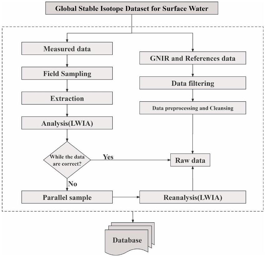
يتكون مجموعة البيانات من ثلاثة عناصر رئيسية: بيانات الموقع الإلكتروني (GNIR،http://nucleus.iaea.org/wiser/exploreيتطلب تسجيل الدخول، آخر وصول: يوليو 2024؛ موقع نظائر الماء،http://wateriso. utah.edu/waterisotopes، آخر وصول: يوليو 2024)، البيانات المقاسة وبيانات المرجع. تشمل مجموعة البيانات 22432 موقعًا لأخذ عينات المياه السطحية عبر سبع قارات (الشكل 1). منذ عام 2015، كان هناك نظام مراقبة إيكوهيدرولوجي قيد التشغيل في حوض نهر شييانغ في المنطقة الجافة شمال غرب الصين، يجمع بشكل منهجي بيانات نظائر المياه السطحية المستقرة (الشكل S1 في الملحق) ويعمل كمصدر رئيسي للبيانات المقاسة.
فيما يتعلق بالبيانات المقاسة، يتم اختيار مواقع أخذ عينات المياه السطحية، كلما كان ذلك ممكنًا، من أماكن تتحرك فيها المياه بسرعة لأن المياه الراكدة غالبًا ما تتأثر بالتلوث والتبخر. بعد شطف زجاجة العينة ثلاث مرات قبل أخذ العينة باستخدام مياه من موقع أخذ العينة، تم وضع الزجاجة تحت سطح الماء مع الفم موجهًا لأعلى وتم ملؤها بحوالي ثلاثة أرباع حجم الزجاجة. بعد الانتهاء من عملية جمع عينة المياه، تم إغلاق الزجاجات بإحكام على الفور؛ وتم لصق أفواهها بشريط لاصق مقاوم للماء؛ وتم لصق ملصقات تحمل اسم موقع أخذ العينة، وتاريخ أخذ العينة ومعلومات إضافية على الزجاجات. تم الاحتفاظ بكل عينة مياه تم جمعها في ثلاجة لتجميدها لتجنب الأخطاء في البيانات الناتجة عن التبخر.
فيما يتعلق ببيانات المرجع، أضفنا مزيدًا من المعلومات إلى قاعدة البيانات من خلال البحث عن مصطلحات “نظير” و”مياه سطحية” و”نهر” في الأوراق المنشورة على موقع Web of Science. اخترنا المقالات العلمية التي تحتوي على بيانات النظائر بصيغ نصية وجداول ورسوم بيانية كمصدر أساسي للبيانات لتعزيز دقة بياناتنا. وقد حددت الأوراق المذكورة نوع جسم الماء بشكل صريح على أنه “مياه سطحية”. بالإضافة إلى بيانات النظائر، جمعنا معلومات مكانية وزمنية، بما في ذلك خطوط العرض والطول لمواقع أخذ العينات والوقت الدقيق لأخذ العينات.
علاوة على ذلك، تم الحصول على البيانات الجوية المستخدمة في هذه الدراسة من مجموعة بيانات إعادة تحليل NCEP-NCAR.https://psl.noaa.gov/data/gridded/data.ncep.reanalysis.html، آخر وصول: يوليو 2024) ومجموعة بيانات CRUTS v.4.07 (https://crudata.uea.ac.uk/cru/dataالبيانات المستخدمة في تقسيم المناخ العالمي مستمدة من تصنيف المناخ العالمي لكوبن (Peel et al.، 2007) (الشكل S2).
الشكل 1. توزيع مواقع العينات في مجموعة البيانات العالمية لنظائر الاستقرار لمياه السطح.

2.2 معالجة البيانات

2.2.1 تجربة

قبل بدء التجربة، تم إزالة العينات المراد تحليلها من الثلاجة ونقلها إلى زجاجات عينة زجاجية سعة 1.5 مل بعد أن ذابت في الغرفة. تم استخدام فلتر بحجم مسام ثم تم تطبيق قطر يبلغ 13 مم لإزالة أي ملوثات، مثل الطين والغبار، التي قد تكون قد حملت مع العينات أثناء النقل. تم تحليل جميع عينات المياه لقيم النظائر المستقرة باستخدام جهاز تحليل نظائر المياه السائلة (DLT-100، لوس غاتوس ريسيرش، الولايات المتحدة الأمريكية). خلال عملية التحديد، تم قياس كل عينة ماء ست مرات متتالية. لمنع تأثير التلوث المتبقي على النتائج، تم تجاهل القياسين الأولين، وتم حساب قيمة النظائر المستقرة كمتوسط للقياسات الأربع الأخيرة. يتم التعبير عن نتائج الاختبار التي تم الحصول عليها كانحراف بالألف عن متوسط مياه المحيط القياسي فيينا (VSMOW):
هنا، يمثل نسبة أو في العينة المجمعة، و هو نسبة أو في عينة المعيار في فيينا. دقة التحليلات لـ و هم و ، على التوالي.

2.2.2 جودة البيانات

تضمنت البيانات المجمعة مشكلات متنوعة مثل القيم المفقودة، والقيم الشاذة، والمدخلات المكررة الواضحة، بالإضافة إلى
تاريخ أخذ العينات والفجوات والمعلومات المفقودة أو غير الصحيحة عن خطوط العرض والطول. لذلك، تم معالجة البيانات الخام المجمعة مسبقًا وتمت تصفيتها لإزالة البيانات الخاطئة.
بالإضافة إلى ذلك، نستخدم برنامج تحليل البيانات بعد القياس لجهاز تحليل نظائر الماء السائل (LWIA) لفحص بيانات النظائر الخام المقاسة. توصي شركة لوس غاتوس للبحوث (LGR) باستخدام برنامج المعالجة المخصص لدينا لتحليل البيانات. يقوم هذا البرنامج بتحميل ملفات البيانات، ويقوم بجميع عمليات التطبيع والمعالجة المطلوبة، ويحفظ البيانات المعالجة كملفات TXT قابلة للقراءة. بالإضافة إلى ذلك، يتحقق جهاز LWIA تلقائيًا من مؤشرات الأعطال في الأجهزة، ويوفر مجموعة من فلاتر البيانات، ويعرض مجموعة متنوعة من العروض الرسومية، ويمكن تكوينه من قبل المستخدم. مع جهاز LWIA، يمكننا معرفة أي قيم بيانات خام للعينة غير صحيحة وتحتاج إلى إعادة اختبار، ويمكننا رؤية أسباب أخطاء البيانات. بالإضافة إلى ذلك، تم فحص جميع بيانات النظائر بدقة لضمان أن كل إدخال يتضمن بيانات واضحة عن “خط الطول”، “خط العرض”، “وقت أخذ العينات” و”النظير”. وتمت إزالة القيم الشاذة والمكررة (الشكل 2).

2.3 الطرق

استنادًا إلى الدراسات السابقة، تم استخدام تحليل التباين الأحادي (ANOVA) لتحديد الأهمية ( في مستوى الثقة) للمنحدرات والاعتراضات لنماذج الانحدار الخطي ل isotopes المستقرة في المياه السطحية و عبر مناطق مناخية مختلفة (Vystavna et al., 2021). علاوة على ذلك، يمكن لنموذج الغابة العشوائية (RF) تقييم أهمية المتغيرات. في هذه الدراسة، استخدمنا نموذج RF لتقييم تأثير العوامل الجوية المختلفة على النظائر المستقرة لمياه السطح على مستوى العالم.
الشكل 2. تدفق معالجة البيانات وبناء مجموعة بيانات نظائر المياه السطحية العالمية المستقرة.
يدمج خوارزمية RF عدة أشجار قرار لتوليد تأثير تراكمي. تتنبأ بنتائج الانحدار استنادًا إلى النتائج المتوسطة لهذه الأشجار العشوائية، مستخدمةً تقنية البوتستراب لتقليل خطر الإفراط في التخصيص (بريمان، 2001؛ هو وآخرون، 2017). تم استخدام كل من خطأ الجذر التربيعي المتوسط (RMSE) وخطأ القيمة المطلقة المتوسطة (MAE) لتقدير خطأ النموذج (كارتال، 2024). يتم وصف عملية الحساب التفصيلية لـ RMSE و MAE في القسم S1 في الملحق.

3 النتائج والمناقشات

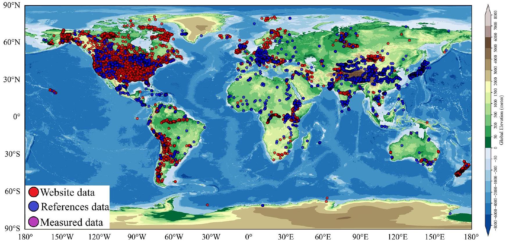
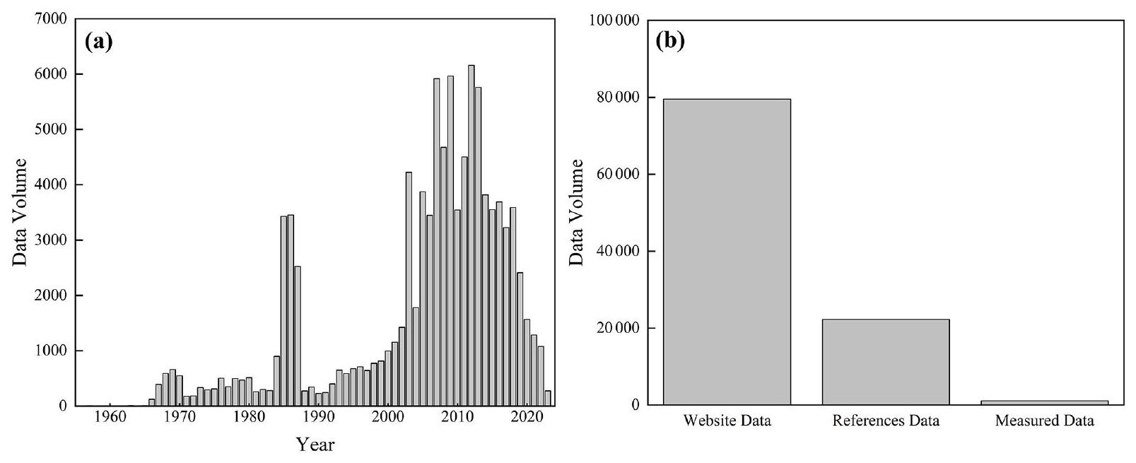
3.1 حجم وتوزيع جغرافي وتغطية زمنية لمجموعات البيانات

كما هو موضح في الشكل 3، تم جمع ما مجموعه 102561 قياسًا لنظائر الهيدروجين والأكسجين المستقرة في المياه السطحية لهذا المجموعة البيانية. يشمل ذلك 79525 بيانات من المواقع الإلكترونية، و1040 بيانات مقاسة، و21946 بيانات مرجعية. تتركز معظم بيانات GNIR بشكل أساسي في عدد قليل من المناطق، مثل الولايات المتحدة وأوروبا الشرقية، وتوزع بشكل متقطع على مستوى العالم. لتوسيع مجموعة البيانات لدينا، قمنا بإدراج بيانات من الأدبيات المنشورة. تغطي مجموعة البيانات الموسعة الآن تقريبًا جميع أنحاء العالم، مع توزيع نسبي متساوٍ، بما في ذلك المناطق التي يصعب الوصول إليها تقليديًا، مثل غرينلاند، وأنتاركتيكا، وغرب أستراليا، والمناطق الجبلية ذات الارتفاعات العالية (الشكل 1). من حيث نطاق الزمن، تغطي مجموعة البيانات الفترة من 1956 إلى 2023، وتوزع معظم البيانات من عام 1990 فصاعدًا، مما يشير أيضًا إلى أن مجموعة البيانات يمكن أن تعكس بشكل أفضل…
حدد توزيع النظائر المستقرة في المياه السطحية على مستوى العالم على مدى العقود الماضية.

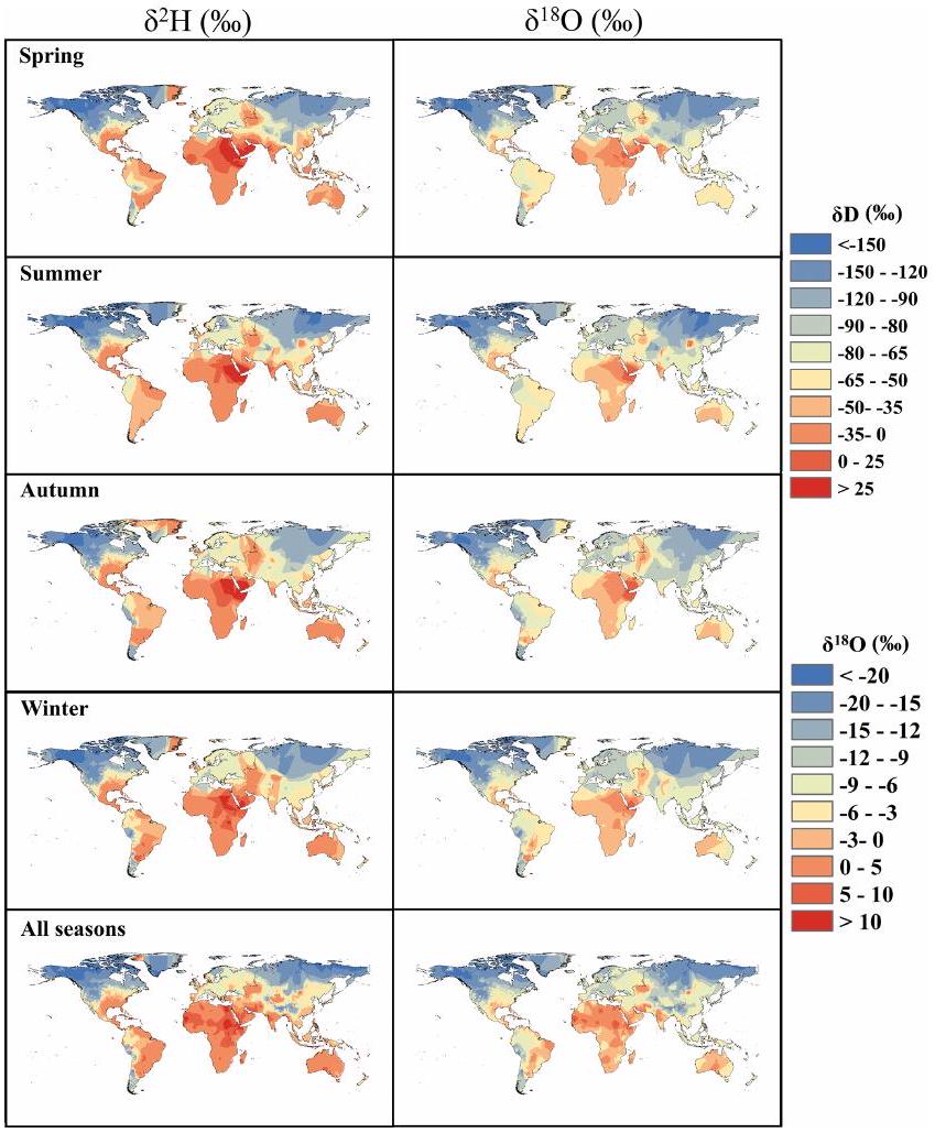
3.2 التغيرات المكانية والزمانية في النظائر المستقرة في المياه السطحية العالمية

التغير في تراوح بين أو إلى ، والتغير في تراوح بين إلى على مستوى مجموعة البيانات الكاملة. على المقياس الموسمي، عادةً ما تظهر نظائر المياه السطحية المستقرة العالمية تباينات ملحوظة، تتميز بقيم أعلى في الصيف وقيم أقل في الشتاء (الشكل 4). لمراقبة هذه التباينات عبر مناطق مختلفة بشكل أفضل، قمنا بتصنيف الكرة الأرضية إلى خمس مناطق مناخية – استوائية، معتدلة، جافة، قارية وقطبية – استنادًا إلى تصنيف مناطق المناخ لكوبن. عبر المناطق المناخية الست، تظهر نظائر المياه السطحية المستقرة تباينات موسمية، مع قيم أعلى في الصيف وقيم أقل في الشتاء، باستثناء المناطق المناخية القطبية. تحدث التباينات الأكثر وضوحًا في المناطق الجافة، مما يبرز تأثير العوامل الجوية على نظائر المياه السطحية المستقرة.
في هذه الأثناء، لوصف التوزيع المكاني للنظائر المستقرة في المياه السطحية العالمية بشكل أفضل، قمنا بإجراء عملية استيفاء لرسم خريطة لتوزيعها المكاني على مستوى العالم (الشكل 5). بشكل عام، و تظهر اتجاهًا متسقًا من القيم المتناقصة تدريجيًا من المناطق الاستوائية إلى العروض العليا ومن المناطق الساحلية إلى المناطق الداخلية في مناطق مثل أوراسيا وأمريكا الشمالية. يكون هذا الاتجاه واضحًا بشكل خاص في المناطق ذات العروض العليا والارتفاعات العالية، حيث تكون القيم أقل بكثير. ومع ذلك، لا تظهر بعض المناطق نمطًا واضحًا في توزيع و القيم. تنجم هذه الشذوذ بشكل أساسي عن العوامل المعقدة التي تؤثر على توليد الجريان وتركيز تدفق المياه في مناطق مختلفة. بالإضافة إلى ذلك، فإن وجود المسطحات المائية المفتوحة، مثل البحيرات والخزانات، يزيد من تفاقم هذه الظاهرة ذات التوزيع غير المنتظم.
لفهم العلاقة بين المياه السطحية والهطول بشكل أفضل، قمنا بمقارنة نتائج الاستيفاء المكاني لنظائر المياه السطحية مع تلك الخاصة بنظائر الهطول العالمية. وجدنا أن توزيع النظائر في المياه السطحية يتماشى إلى حد كبير مع توزيع النظائر في الهطول عبر معظم المناطق (الشكل S3). تنشأ هذه التوافقية بشكل أساسي لأن المياه السطحية يتم إعادة شحنها بشكل رئيسي بواسطة الهطول. علاوة على ذلك، فإن التباين المكاني في التركيب النظائري للمياه السطحية يعد مؤشراً قيماً على علاقة إعادة الشحن بينها وبين المياه الجوفية والهطول (كيندال وكوبلين، 2001). يتضح ذلك بشكل خاص في المناطق الاستوائية وعلى ارتفاعات عالية، حيث يعد الهطول المصدر الرئيسي لإعادة شحن المياه السطحية. في هذه المناطق، تظهر التوزيعات المكانية لنظائر المياه السطحية ونظائر الهطول درجة عالية من التشابه (الشكل S3).
الشكل 3. توزيع مجموعة بيانات نظائر المياه السطحية العالمية المستقرة. (أ) توزيع السلاسل الزمنية و (ب) توزيع الفئات.
الشكل 4. التغير الموسمي في و في المياه السطحية في مناطق مناخية مختلفة (الأرقام تشير إلى كمية بيانات النظائر المستقرة).

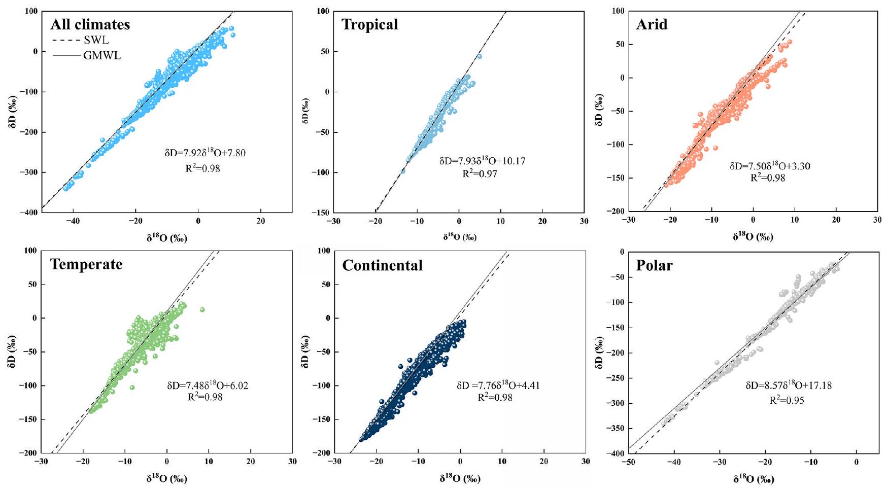
3.3 المياه السطحية العالمية و الارتباطات

هنا، قمنا بتناسب و مع المياه السطحية في ست مناطق مناخية، وأشارت النتائج إلى وجود ارتباط قوي بين و عبر المناطق المناخية الست (الشكل 6). العلاقة بين و للمياه السطحية العالمية هي ( )، والتي تقترب من التقاطع والميل لخط المياه المائية العالمية (GMWL: )، وهذا يؤكد مرة أخرى أن مصدر إعادة شحن المياه السطحية العالمية هو الهطول. ومع ذلك، كانت الخطوط المتناسبة لـ و للمياه السطحية مختلفة بشكل ملحوظ في مناطق مناخية مختلفة (الشكل 6)، وكانت الخطوط المتناسبة لـ و تظهر
أدنى تقاطع وميل تحت مناخ جاف ( )، مما يشير أيضاً إلى أنه، تحت مناخ جاف، تعرضت المياه السطحية لتبخر كبير، مما أدى إلى إثراء نظائري للمياه السطحية وارتفاع قيم و مقارنة بالمناطق المناخية الأخرى. في أبرد منطقة مناخية قطبية، تكون الخط المتناسب لـ و هو ( )، ويشير الميل والتقاطع الأعلى إلى أنه، تحت تأثير المناخ البارد، تتعرض المياه السطحية لتبخر قليل، وقد تكون المياه السطحية في شكل ثلج وجليد، مما يؤدي إلى قيم أقل بكثير من و مقارنة بالمناطق المناخية الأخرى.
الشكل 5. التوزيع المكاني للمياه السطحية العالمية و في مواسم مختلفة (بيانات غير موزونة، باستخدام طرق شبكة كريغينغ).

3.4 العوامل المؤثرة على النظائر المستقرة في المياه السطحية

بالنسبة لنظائر الهطول المستقرة، هناك “تأثير خط العرض” و”تأثير القارة” كبير (دانسغارد، 1964)؛ يتم ملاحظة هذه النمط من التغير أيضاً في النظائر المستقرة للمياه السطحية، والتي تتميز بانخفاض تدريجي في قيم النظائر المستقرة من خطوط العرض المنخفضة إلى العالية ومن المناطق الساحلية إلى المناطق الداخلية الجافة. ومع ذلك، في المناطق ذات خطوط العرض المنخفضة بالقرب من خط الاستواء، حيث يتم إعادة شحن المياه السطحية بشكل رئيسي بواسطة الهطول وحيث لا تتغير العوامل المناخية بشكل كبير مع خط العرض، لا يوجد تباين مكاني كبير في النظائر المستقرة للمياه السطحية.
بالإضافة إلى ذلك، أظهرت العديد من الدراسات أن التركيب النظائري المستقر للمياه السطحية يتأثر بشكل رئيسي بالعوامل المناخية (أراجواس-أراجواس وآخرون، 1998؛ دانسغارد، 1964؛ وانغ وآخرون، 2017). لتقييم أهمية المتغيرات الجوية المختلفة بالنسبة للنظائر المستقرة للمياه السطحية على مستوى العالم، استخدمنا نموذج RF. أشار تحليل الانحدار RF المتناسب مع النظائر المستقرة للمياه السطحية إلى توافق قوي للنموذج لكل من مجموعات التدريب والاختبار. وهذا يشير إلى أن المتغيرات مثل درجة الحرارة، والهطول، والتبخر المحتمل، وضغط البخار، وسرعة الرياح، والرطوبة النسبية تمتلك قوة تفسيرية كبيرة للنظائر المستقرة للمياه السطحية (الشكل 7). تظهر نتائج التحقق من نموذج RF
أداء تنبؤ ممتاز لكل من و ، مع تظهر دقة تنبؤ أفضل من ، كما يتضح من قيم RMSE و MAE الأصغر (الجدول S1). من بين العوامل الجوية الستة التي تم النظر فيها، تمارس درجة الحرارة أقوى تأثير على النظائر المستقرة للمياه السطحية. كما يظهر التبخر المحتمل تأثيراً قوياً، مما يشير إلى أن درجة الحرارة والتبخر هما العاملان الرئيسيان اللذان يحكمان التغيرات في النظائر المستقرة للمياه السطحية العالمية. بالإضافة إلى ذلك، تظهر الرطوبة النسبية وسرعة الرياح قوة تفسيرية عالية لتغيرات النظائر المستقرة للمياه السطحية. أشارت الدراسات السابقة إلى أن سرعة الرياح والرطوبة النسبية تؤثر بشكل كبير على التبخر من المسطحات المائية (غالارت وآخرون، 2024؛ سكرزيبيك وآخرون، 2015)، مما يمكن أن يؤثر بعد ذلك على النظائر المستقرة للمياه السطحية. بينما يقدم ضغط البخار والهطول تفسيرات أضعف لتغيرات النظائر المستقرة للمياه السطحية، يمكن أن تُعزى هذه العوامل إلى حد كبير إلى زمن الإقامة للمياه السطحية ودورة المياه المحلية. يختلف زمن الإقامة للمياه السطحية وخصائص الدورة الهيدرولوجية المحلية بشكل كبير عبر مناطق مختلفة. عادةً ما تحتوي المسطحات المائية الكبيرة المفتوحة على أوقات إقامة أطول ودورات هيدرولوجية أبطأ، مما يؤدي إلى تركيبة نظائرية أكثر غنى للمياه السطحية (فينغ وآخرون، 2016). في المقابل، قد تظهر المسطحات المائية ذات الدورات الهيدرولوجية الأسرع، مثل الأنهار، تركيبات نظائرية مختلفة (ألا-آهو وآخرون، 2018). ومع ذلك، يتطلب تفسير هذه الأنماط على نطاق واسع مزيدًا من التحقيق والتحقق.
في الوقت نفسه، بالنسبة للبحيرات والخزانات وغيرها من المسطحات المائية الكبيرة المفتوحة، يمكن أن تكون الضوابط على النظائر المستقرة للمياه السطحية أكثر تعقيدًا. أظهرت الدراسات أن التغيرات العالمية في النظائر المستقرة في البحيرات ناتجة عن التأثيرات المشتركة للإشعاع الشمسي، والتبخر، وحجم منطقة التجميع وعوامل أخرى (فيستافنا وآخرون، 2021). تختلف هذه الضوابط عبر مناطق مختلفة، مما يساهم في تركيبات نظائرية مستقرة متنوعة في المياه السطحية في جميع أنحاء العالم. على سبيل المثال، في المناطق الجافة، يتحكم الإشعاع الشمسي بشكل أساسي في التغيرات النظيرية المستقرة في البحيرات، بينما في المناطق المناخية المعتدلة، يلعب التبخر والنقل دورًا رئيسيًا. وبالتالي، تختلف العوامل المؤثرة على النظائر المستقرة للمياه السطحية بشكل كبير عبر مناطق مختلفة. ومع ذلك، تشير الأنماط العامة إلى أن العوامل الجغرافية والمناخية تحكم بشكل جماعي التغيرات النظيرية المستقرة في المياه السطحية داخل منطقة معينة.

3.5 التحديات والقيود في بناء مجموعات بيانات نظائر المياه السطحية والاتجاهات البحثية المستقبلية

حالياً، بسبب قيود تقنيات وأساليب أخذ العينات، قد تكون هناك اختلافات كبيرة في طرق وتكرار أخذ العينات عبر بيئات جيولوجية وظروف هيدروجيولوجية مختلفة. يمكن أن تؤثر هذه الاختلافات على مقارنة وتحليل البيانات. يتطلب بناء مجموعة بيانات شاملة للنظائر للمياه السطحية
الشكل 6. العلاقة بين و في مناطق مناخية مختلفة.
اعتبار دقيق للتغطية المكانية والزمانية لضمان دقة البيانات وقابليتها للمقارنة (أنكور وآخرون، 2019). ومع ذلك، بسبب القيود المتعلقة بالتكلفة والعمالة والمعدات، فضلاً عن الظروف الطبيعية القاسية في مناطق أخذ العينات، فإنه من الصعب تحقيق المراقبة المستمرة لمختلف أحواض المياه على مدى فترات زمنية طويلة. تؤدي هذه القيود إلى بعض النقص في البيانات من حيث المقاييس المكانية والزمانية (بينا وآخرون، 2014). بالإضافة إلى ذلك، لم يتم بعد توحيد دقة بيانات النظائر المستقرة الحالية بسبب مشكلات مثل حفظ العينات، والتقنيات التحليلية، ودقة الأدوات. قد تؤدي هذه التحديات إلى مشاكل في قابلية المقارنة والموثوقية العامة للبيانات.
في المستقبل، سيكون من الضروري إنشاء معايير موحدة لجمع البيانات وتخزينها ومشاركتها من أجل إنشاء قاعدة بيانات عالمية لل isotopes لمياه السطح. بالإضافة إلى ذلك، سيكون من الضروري دمج البيانات من مصادر وأوقات ومواقع مختلفة لتطوير قاعدة بيانات عالمية أكثر شمولاً لل isotopes لمياه السطح (Chen et al., 2024; Zhu et al., 2022). مع التقدم في الذكاء الاصطناعي، هناك اتجاه متزايد نحو دمج بيانات isotopes مع النمذجة الهيدرولوجية (Gierz et al., 2017; Nelson et al., 2021). يعد هذا الدمج بتحسين فهمنا للعمليات الهيدرولوجية وتحسين ممارسات إدارة موارد المياه. علاوة على ذلك، فإنه يسهل تحسين التغطية المكانية والزمانية للبيانات، مما يوفر رؤى أكثر قوة حول ديناميات المياه والتفاعلات داخل النظم البيئية. في الوقت نفسه، في سياق التغير العالمي،
أصبح دراسة تغير المناخ والنظائر متكاملة بشكل متزايد ومتعددة التخصصات. على المدى الطويل، هناك إمكانية لتطوير فهم شامل وتطبيق مجموعات بيانات النظائر لمياه السطح. سيعتمد هذا التطور على دمج الخبرات من تخصصات مثل الجيولوجيا، والهيدرولوجيا، والأرصاد الجوية وغيرها، مما يعزز نهجًا شاملاً لدراسة وإدارة موارد المياه في مناخ متغير.

4 توفر البيانات

مجموعة البيانات العالمية لنظائر مستقرة لمياه السطح متاحة الآن للجمهور، ويمكن العثور على البيانات فيhttps://doi.org/10.17632/fs7rwp7fpr. 2 (زو، 2024).

5 الخاتمة

توفر مجموعة البيانات العالمية لنظائر الكربون المستقرة للمياه السطحية معلومات حيوية لتعزيز فهمنا لدورة المياه، وتغير المناخ، ورصد البيئة. في هذه الدراسة، أنشأنا مجموعة بيانات عالمية لنظائر الكربون المستقرة للمياه السطحية من خلال دمج البيانات المقاسة وبيانات المرجع من بيانات المحطات الموجودة. وقد أغنى هذا النهج مجموعة البيانات وسمح بإجراء تحليل شامل عبر مناطق ومناخات مختلفة. تكشف النتائج عن تباينات مكانية وزمنية ملحوظة في تركيبة نظائر الكربون المستقرة للمياه السطحية العالمية، مع ملاحظة اختلافات كبيرة في التركيب النظائري للمياه السطحية.
الشكل 7. العلاقة بين و تم تحليل العوامل الجوية باستخدام نموذج RF. (أ) نتائج الانحدار لمجموعة التدريب. (ب) نتائج الانحدار لمجموعة الاختبار. (ج) نتائج الانحدار لمجموعة التدريب. (د) نتائج الانحدار لمجموعة الاختبار. (هـ) تأثير العوامل الجوية على . (ف) تأثير العوامل الجوية على .
المياه عبر المناخات المختلفة. تتأثر التغيرات في نظائر المياه السطحية العالمية بمزيج من العوامل الجغرافية والأرصادية، حيث تعتبر درجة الحرارة والتبخر والنتح من بين العوامل المناخية التي تظهر قوة تفسيرية قوية لتكوين نظائر المياه السطحية. تلعب ملاحظات النظائر المستقرة في المياه السطحية العالمية دورًا حاسمًا في تعزيز فهمنا لدورة المياه العالمية، وتغير المناخ، وإدارة الموارد المائية. إنها توفر دعمًا أساسيًا للبيانات للبحث بين التخصصات، مما يساعد على كشف الروابط بين العمليات الهيدرولوجية، وتغير المناخ، والتغيرات البيئية في جميع أنحاء العالم. على الرغم من أننا قد أغنينا
على الرغم من استخدام هذه المجموعة من البيانات قدر الإمكان، لا تزال هناك مناطق ذات بيانات نادرة، مثل سيبيريا وشرق أوروبا. في المستقبل، يجب أن تركز الجهود على تعزيز الملاحظات في هذه المناطق الصعبة حيث تتوفر البيانات بشكل محدود. يمكن تحسين دقة بيانات نظائر المياه السطحية العالمية من خلال دمج الأساليب متعددة التخصصات واستغلال طرق الذكاء الاصطناعي. ستساعد هذه الطريقة في سد الفجوات في البيانات، وتعزيز الدقة، وتوفير رؤى أكثر شمولاً حول ديناميات المياه العالمية والتغيرات البيئية.
ملحق. الملحق المتعلق بهذه المقالة متاح على الإنترنت فيhttps://doi.org/10.5194/essd-17-2135-2025-supplement.
مساهمات المؤلفين. GZ و RL: الكتابة (إعداد المسودة الأصلية). SL و LC: تنسيق البيانات. XQ: الكتابة (المراجعة والتحرير). GM و YW: المنهجية. WL: التحقيق. ZZ و JY و YG: البرمجيات.
المصالح المتنافسة. لقد أعلن المؤلف المسؤول أنه لا يوجد لدى أي من المؤلفين مصالح متنافسة.
تنبيه. ملاحظة الناشر: تظل منشورات كوبرنيكوس محايدة فيما يتعلق بالمطالبات القضائية الواردة في النص، والخرائط المنشورة، والانتماءات المؤسسية، أو أي تمثيل جغرافي آخر في هذه الورقة. بينما تبذل منشورات كوبرنيكوس كل جهدها لتضمين أسماء الأماكن المناسبة، فإن المسؤولية النهائية تقع على عاتق المؤلفين.
الشكر والتقدير. نشكر المحرر، يويكيانغ تشانغ، والمراجعين المجهولين على تقديم قائمة من التعليقات النقدية والقيمة جداً التي ساعدت في تحسين الورقة. يود المؤلفون أن يشكروا آني ل. بوتمان وغابرييل ج. بوين على مساهماتهما في قاعدة بيانات wiDB والوكالة الدولية للطاقة الذرية على مساهماتها المتميزة فيما يتعلق بمجموعة بيانات GNIR. أخيراً، يشكر المؤلفون جميع الباحثين والمؤسسات التي قدمت البيانات.
الدعم المالي. تم دعم هذه الدراسة من قبل المؤسسة الوطنية للعلوم الطبيعية في الصين (أرقام المنح 42371040 و 41971036)، المؤسسة الرئيسية للعلوم الطبيعية في مقاطعة قانسو (رقم المنحة 23JRRA698)، برنامج البحث والتطوير الرئيسي في مقاطعة قانسو (رقم المنحة 22YF7NA122)، مشروع مجموعة الابتكار في البحث الأساسي في مقاطعة قانسو (رقم المنحة 22JR5RA129)، برنامج العلماء الشباب من الضوء الغربي للأكاديمية الصينية للعلوم، برنامج زراعة المشاريع الرئيسية في جامعة نورث ويست نورمال (رقم المنحة NWNU-LKZD-202302)، ومشروع خطة عمل تحقيق إنجازات البحث العلمي في جامعة نورث ويست نورمال (رقم المنحة NWNU-LZKX-202303).
بيان المراجعة. تم تحرير هذه الورقة بواسطة يويانغ تشانغ وتمت مراجعتها من قبل اثنين من المحكمين المجهولين.

References

Aggarwal, P. K., Alduchov, O., Araguás Araguás, L., Dogramaci, S., Katzlberger, G., Kriz, K., Kulkarni, K. M., Kurttas, T., Newman, B. D., and Purcher, A.: New capabilities for studies using isotopes in the water cycle, EoS Transactions, 88, 537-538, https://doi.org/10.1029/2007EO490002, 2007.
Aggarwal, P. K., Alduchov, O. A., Froehlich, K. O., AraguasAraguas, L. J., Sturchio, N. C., and Kurita, N.: Stable isotopes in global precipitation: A unified interpretation based on atmospheric moisture residence time, Geophys. Res. Lett., 39, 2012GL051937, https://doi.org/10.1029/2012GL051937, 2012.
Ala-aho, P., Soulsby, C., Pokrovsky, O. S., Kirpotin, S. N., Karlsson, J., Serikova, S., Manasypov, R., Lim, A., Krickov, I., Kolesnichenko, L. G., Laudon, H., and Tetzlaff, D.: Permafrost and lakes control river isotope composition across a boreal Arctic transect in the Western Siberian lowlands, Environ. Res. Lett., 13, 034028, https://doi.org/10.1088/1748-9326/aaa4fe, 2018.
Ankor, M. J., Tyler, J. J., and Hughes, C. E.: Development of an autonomous, monthly and daily, rainfall sampler for isotope research, J. Hydrol., 575, 31-41, https://doi.org/10.1016/j.jhydrol.2019.04.074, 2019.
Araguás-Araguás, L., Froehlich, K., and Rozanski, K.: Stable isotope composition of precipitation over southeast Asia, J. Geophys. Res., 103, 28721-28742, https://doi.org/10.1029/98JD02582, 1998.
Autio, A., Ala-Aho, P., Rossi, P. M., Ronkanen, A.-K., Aurela, M., Lohila, A., Korpelainen, P., Kumpula, T., Klöve, B., and Marttila, H.: Groundwater exfiltration pattern determination in the sub-arctic catchment using thermal imaging, stable water isotopes and fully-integrated groundwater-surface water modelling, J. Hydrol., 626, 130342, https://doi.org/10.1016/j.jhydrol.2023.130342, 2023.
Bershaw, J., Saylor, J. E., Garzione, C. N., Leier, A., and Sundell, K. E.: Stable isotope variations ( and ) in modern waters across the Andean Plateau, Geochim. Cosmochim. Ac., 194, 310-324, https://doi.org/10.1016/j.gca.2016.08.011, 2016.
Bowen, G. J., Kennedy, C. D., Liu, Z., and Stalker, J.: Water balance model for mean annual hydrogen and oxygen isotope distributions in surface waters of the contiguous United States, J. Geophys. Res., 116, G04011, https://doi.org/10.1029/2010JG001581, 2011.
Bowen, G. J., Cai, Z., Fiorella, R. P., and Putman, A. L.: Isotopes in the Water Cycle: Regional- to Global-Scale Patterns and Applications, Annu. Rev. Earth Planet. Sci., 47, 453-479, https://doi.org/10.1146/annurev-earth-053018-060220, 2019.
Breiman, L.: Random Forests, Mach. Learn., 45, 5-32, https://doi.org/10.1023/A:1010933404324, 2001.
Chahine, M. T.: The hydrological cycle and its influence on climate, Nature, 359, 373-380, https://doi.org/10.1038/359373a0, 1992.
Chen, L., Wang, Q., Zhu, G., Lin, X., Qiu, D., Jiao, Y., Lu, S., Li, R., Meng, G., and Wang, Y.: Dataset of stable isotopes of precipitation in the Eurasian continent, Earth Syst. Sci. Data, 16, 1543-1557, https://doi.org/10.5194/essd-16-1543-2024, 2024.
Chen, Y., Helliker, B. R., Tang, X., Li, F., Zhou, Y., and Song, X.: Stem water cryogenic extraction biases estimation in deuterium isotope composition of plant source water, P. Natl. Acad. Sci. USA, 117, 33345-33350, https://doi.org/10.1073/pnas.2014422117, 2020.
Cooley, S. W., Ryan, J. C., and Smith, L. C.: Human alteration of global surface water storage variability, Nature, 591, 78-81, https://doi.org/10.1038/s41586-021-03262-3, 2021.
Dansgaard, W.: Stable isotopes in precipitation, Tellus, 16, 436468, https://doi.org/10.1111/j.2153-3490.1964.tb00181.x, 1964.
Darling, W. G.: Hydrological factors in the interpretation of stable isotopic proxy data present and past: a Eu-
ropean perspective, Quaternary Sci. Rev., 23, 743-770, https://doi.org/10.1016/j.quascirev.2003.06.016, 2004.
Dudley, B. D., Yang, J., Shankar, U., and Graham, S. L.: A method for predicting hydrogen and oxygen isotope distributions across a region’s river network using reach-scale environmental attributes, Hydrol. Earth Syst. Sci., 26, 4933-4951, https://doi.org/10.5194/hess-26-4933-2022, 2022.
Dutton, A., Wilkinson, B. H., Welker, J. M., Bowen, G. J., and Lohmann, K. C.: Spatial distribution and seasonal variation in of modern precipitation and river water across the conterminous USA, Hydrol. Process., 19, 4121-4146, https://doi.org/10.1002/hyp.5876, 2005.
Feng, X., Lauder, A. M., Posmentier, E. S., Kopec, B. G., and Virginia, R. A.: Evaporation and transport of water isotopologues from Greenland lakes: The lake size effect, Quaternary Sci. Rev., 131, 302-315, https://doi.org/10.1016/j.quascirev.2015.07.029, 2016.
Gallart, F., González-Fuentes, S., and Llorens, P.: Technical note: Isotopic fractionation of evaporating waters: effect of sub-daily atmospheric variations and eventual depletion of heavy isotopes, Hydrol. Earth Syst. Sci., 28, 229-239, https://doi.org/10.5194/hess-28-229-2024, 2024.
Gierz, P., Werner, M., and Lohmann, G.: Simulating climate and stable water isotopes during the Last Interglacial using a coupled climate-isotope model, J. Adv. Model. Earth Syst., 9, 2027-2045, https://doi.org/10.1002/2017MS001056, 2017.
Halder, J., Terzer, S., Wassenaar, L. I., Araguás-Araguás, L. J., and Aggarwal, P. K.: The Global Network of Isotopes in Rivers (GNIR): integration of water isotopes in watershed observation and riverine research, Hydrol. Earth Syst. Sci., 19, 3419-3431, https://doi.org/10.5194/hess-19-3419-2015, 2015.
Hu, X., Belle, J. H., Meng, X., Wildani, A., Waller, L. A., Strickland, M. J., and Liu, Y.: Estimating PM 2.5 Concentrations in the Conterminous United States Using the Random Forest Approach, Environ. Sci. Technol., 51, 6936-6944, https://doi.org/10.1021/acs.est.7b01210, 2017.
Immerzeel, W. W., Lutz, A. F., Andrade, M., Bahl, A., Biemans, H., Bolch, T., Hyde, S., Brumby, S., Davies, B. J., Elmore, A. C., Emmer, A., Feng, M., Fernández, A., Haritashya, U., Kargel, J. S., Koppes, M., Kraaijenbrink, P. D. A., Kulkarni, A. V., Mayewski, P. A., Nepal, S., Pacheco, P., Painter, T. H., Pellicciotti, F., Rajaram, H., Rupper, S., Sinisalo, A., Shrestha, A. B., Viviroli, D., Wada, Y., Xiao, C., Yao, T., and Baillie, J. E. M.: Importance and vulnerability of the world’s water towers, Nature, 577, 364-369, https://doi.org/10.1038/s41586-019-1822-y, 2020.
Jameel, Y., Stahl, M., Michael, H., Bostick, B. C., Steckler, M. S., Schlosser, P., Van Geen, A., and Harvey, C.: Shift in groundwater recharge of the Bengal Basin from rainfall to surface water, Commun. Earth Environ., 4, 14, https://doi.org/10.1038/s43247-022-00650-z, 2023.
Joussaume, S., Sadourny, R., and Jouzel, J.: A general circulation model of water isotope cycles in the atmosphere, Nature, 311, 24-29, https://doi.org/10.1038/311024a0, 1984.
Kartal, V.: Machine learning-based streamflow forecasting using CMIP6 scenarios: Assessing performance and improving hydrological projections and climate change, Hydrol. Process., 38, e15204, https://doi.org/10.1002/hyp.15204, 2024.
Kendall, C. and Coplen, T. B.: Distribution of oxygen-18 and deuterium in river waters across the United States, Hydrol. Process., 15, 1363-1393, https://doi.org/10.1002/hyp.217, 2001.
Liu, M., Vecchi, G., Soden, B., Yang, W., and Zhang, B.: Enhanced hydrological cycle increases ocean heat uptake and moderates transient climate change, Nat. Clim. Chang., 11, 848-853, https://doi.org/10.1038/s41558-021-01152-0, 2021.
Mehta, P., Siebert, S., Kummu, M., Deng, Q., Ali, T., Marston, L., Xie, W., and Davis, K. F.: Half of twenty-first century global irrigation expansion has been in water-stressed regions, Nat. Water, 2, 254-261, https://doi.org/10.1038/s44221-024-00206-9, 2024.
Nelson, D. B., Basler, D., and Kahmen, A.: Precipitation isotope time series predictions from machine learning applied in Europe, P. Natl. Acad. Sci. USA, 118, e2024107118, https://doi.org/10.1073/pnas.2024107118, 2021.
Peel, M. C., Finlayson, B. L., and McMahon, T. A.: Updated world map of the Köppen-Geiger climate classification, Hydrol. Earth Syst. Sci., 11, 1633-1644, https://doi.org/10.5194/hess-11-16332007, 2007.
Penna, D., Ahmad, M., Birks, S. J., Bouchaou, L., Brenčič, M., Butt, S., Holko, L., Jeelani, G., Martínez, D. E., Melikadze, G., Shanley, J. B., Sokratov, S. A., Stadnyk, T., Sugimoto, A., and Vreča, P.: A new method of snowmelt sampling for water stable isotopes, Hydrol. Process., 28, 5637-5644, https://doi.org/10.1002/hyp.10273, 2014.
Penna, D., Hopp, L., Scandellari, F., Allen, S. T., Benettin, P., Beyer, M., Geris, J., Klaus, J., Marshall, J. D., Schwendenmann, L., Volkmann, T. H. M., von Freyberg, J., Amin, A., Ceperley, N., Engel, M., Frentress, J., Giambastiani, Y., McDonnell, J. J., Zuecco, G., Llorens, P., Siegwolf, R. T. W., Dawson, T. E., and Kirchner, J. W.: Ideas and perspectives: Tracing terrestrial ecosystem water fluxes using hydrogen and oxygen stable isotopes – challenges and opportunities from an interdisciplinary perspective, Biogeosciences, 15, 6399-6415, https://doi.org/10.5194/bg-15-6399-2018, 2018.
Reckerth, A., Stichler, W., Schmidt, A., and Stumpp, C.: Long-term data set analysis of stable isotopic composition in German rivers, J. Hydrol., 552, 718-731, https://doi.org/10.1016/j.jhydrol.2017.07.022, 2017.
Satoh, Y., Yoshimura, K., Pokhrel, Y., Kim, H., Shiogama, H., Yokohata, T., Hanasaki, N., Wada, Y., Burek, P., Byers, E., Schmied, H. M., Gerten, D., Ostberg, S., Gosling, S. N., Boulange, J. E. S., and Oki, T.: The timing of unprecedented hydrological drought under climate change, Nat. Commun., 13, 3287, https://doi.org/10.1038/s41467-022-30729-2, 2022.
Schulte, P., Van Geldern, R., Freitag, H., Karim, A., Négrel, P., Petelet-Giraud, E., Probst, A., Probst, J.-L., Telmer, K., Veizer, J., and Barth, J. A. C.: Applications of stable water and carbon isotopes in watershed research: Weathering, carbon cycling, and water balances, Earth-Sci. Rev., 109, 20-31, https://doi.org/10.1016/j.earscirev.2011.07.003, 2011.
Skrzypek, G., Mydłowski, A., Dogramaci, S., Hedley, P., Gibson, J. J., and Grierson, P. F.: Estimation of evaporative loss based on the stable isotope composition of water using Hydrocalculator, J. Hydrol., 523, 781-789, https://doi.org/10.1016/j.jhydrol.2015.02.010, 2015.
Sprenger, M., Leistert, H., Gimbel, K., and Weiler, M.: Illuminating hydrological processes at the soil-vegetation-atmosphere in-
terface with water stable isotopes, Rev. Geophys., 54, 674-704, https://doi.org/10.1002/2015RG000515, 2016.
Vystavna, Y., Harjung, A., Monteiro, L. R., Matiatos, I., and Wassenaar, L. I.: Stable isotopes in global lakes integrate catchment and climatic controls on evaporation, Nat. Commun., 12, 7224, https://doi.org/10.1038/s41467-021-27569-x, 2021.
Wang, S., Zhang, M., Crawford, J., Hughes, C. E., Du, M., and Liu, X.: The effect of moisture source and synoptic conditions on precipitation isotopes in arid central Asia, J. Geophys. Res.-Atmos., 122, 2667-2682, https://doi.org/10.1002/2015JD024626, 2017.
Zhu, G.: Global Stable Isotope Dataset for Surface Water, V2, Mendeley Data [data set], https://doi.org/10.17632/fs7rwp7fpr.2, 2024.
Zhu, G., Liu, Y., Shi, P., Jia, W., Zhou, J., Liu, Y., Ma, X., Pan, H., Zhang, Y., Zhang, Z., Sun, Z., Yong, L., and Zhao, K.: Stable water isotope monitoring network of different water bodies in Shiyang River basin, a typical arid river in China, Earth Syst. Sci. Data, 14, 3773-3789, https://doi.org/10.5194/essd-14-37732022, 2022.

Journal: Earth system science data, Volume: 17, Issue: 5
DOI: https://doi.org/10.5194/essd-17-2135-2025
Publication Date: 2025-05-21

Global Stable Isotope Dataset for Surface Water

Rui Li , Guofeng Zhu , Longhu Chen , Xiaoyu Qi , Siyu Lu , Gaojia Meng , Yuhao Wang , Wenmin Li , Zhijie Zheng , Jiangwei Yang , and Yani Gun College of Geography and Environmental Science, Northwest Normal University, Lanzhou 730070, Gansu, China Shiyang River Ecological Environment Observation Station, Northwest Normal University, Lanzhou 730070, Gansu, China Key Laboratory of Resource Environment and Sustainable Development of Oasis, Gansu Province, Lanzhou 730070, Gansu, ChinaCorrespondence: Guofeng Zhu (zhugf@nwnu.edu.cn)

Received: 16 July 2024 – Discussion started: 13 August 2024
Revised: 9 December 2024 – Accepted: 5 March 2025 – Published: 21 May 2025

Abstract

Hydrogen and oxygen stable isotopes are widely used as tracers of the water cycle, and surface water is an integral part of the water cycle. Compared with other waterbodies, surface water is more susceptible to different natural and anthropogenic factors, and an accurate understanding of surface water changes is of great significance in ensuring regional water security, maintaining ecological balance, and promoting sustainable economic and social development. The spatial and temporal distributions of global surface water stable isotope data are extremely uneven on a global scale due to factors such as observation conditions and instrumental analysis. For this reason, we have compiled and analysed the stable hydrogen and oxygen isotope data in surface water from 22389 sampling stations worldwide from 1956 to 2023, with 102511 data records. The results indicate the following: (1) global surface water stable isotopes are gradually depleted from the Equator to the poles and from the coast to the interior. However, there are significant differences in the spatial and temporal distributions of surface water isotopes in different regions. (2) The variation in stable isotopes in surface water is controlled by geographic location, topographic conditions and meteorological factors (especially temperature), and its heterogeneity is considerable. The global stable isotope dataset of surface water provides vital information for an in-depth understanding of the water cycle and climate change. It can provide essential data references for global water resource management and research. The Global Stable Isotope Dataset for Surface Water is available at https://doi.org/10.17632/fs7rwp7fpr.2 (Zhu, 2024).

1 Introduction

Water resources are an essential material basis for human survival and are indispensable for maintaining sustainable local socio-economic development, preserving ecological health and maintaining ecosystem stability (Immerzeel et al., 2020; Mehta et al., 2024). Due to human activity and climate change, global hydrological systems have changed in recent decades, increasing ecological vulnerability and sensitivity to climate change (Chahine, 1992; Liu et al., 2021; Satoh et al., 2022). Hydrogen and oxygen isotopes, as kinds of stable isotopes widely present in the water column (Reckerth et al.,
2017; Sprenger et al., 2016), are important elements for conducting water cycle studies and have an essential indicative role in the study of the water cycle (Aggarwal et al., 2007; Joussaume et al., 1984; Vystavna et al., 2021). However, due to restrictions imposed by their conditions in various regions of the world, there are a number of difficulties and constraints in the gathering, integration and analysis of current stable isotope data for surface water (Chen et al., 2020; Penna et al., 2018).
In 1960, the Global Network of Isotopes in Precipitation (GNIP) was created by the International Atomic Energy Agency (IAEA) and the World Meteorological Orga-
nization (WMO), with the aim of constructing a worldwide monitoring network focusing on the in-depth study of hydrogen and oxygen isotopes in precipitation (Aggarwal et al., 2012). Compared to the monitoring of global stable isotopes in precipitation, global surface water monitoring is lagging behind. In 2002, the IAEA started building the Global Network of Isotopes in Rivers (GNIR), which aims to study the interactions between surface water and groundwater using stable isotopes in runoff and to identify the effects of climate change on river runoff and the effects of human activity on riverine variability (Halder et al., 2015). Many academics worldwide have studied the stable isotope composition of surface water. Around the world, scholars engaging in surface water stable isotope research have achieved many results; for example, a researcher using the US river water stable isotope data mapped the isotope distribution of US river water and used the model to analyse the US river water isotope changes (Bowen et al., 2011; Dutton et al., 2005). In addition, the stable isotope composition of surface water is affected by a variety of hydrological processes such as precipitation, evaporation and surface runoff and can therefore provide valuable information on water cycle processes, water resource management and the impacts of climate change (Bowen et al., 2019; Darling, 2004; Schulte et al., 2011). The source, flow, accumulation and change rule of surface water can be thoroughly understood by analysing and interpreting stable isotope data, which can offer a scientific foundation for water resource management, water resource assessment, and ecological and environmental protection (Dudley et al., 2022). In addition, surface water, as a “link” between groundwater and precipitation (Cooley et al., 2021), offers fresh scientific perspectives on a variety of hydrogeological phenomena, including the hydrogeologic evolution of the basin (Bershaw et al., 2016), groundwater-surface water interactions(Autio et al., 2023), groundwater recharge (Jameel et al., 2023) and precipitation processes (Reckerth et al., 2017).
The establishment of a global stable isotope dataset for surface water is of great significance in the current context of global climate change and water scarcity. The dataset will help integrate and utilise surface water stable isotope data from various regions, improve the accessibility and usability of stable isotope data, and provide more abundant and reliable data support for researchers to carry out global-scale hydrological and environmental studies. In addition, based on the global surface water stable isotope dataset, the analysis of the driving force of meteorological factors in the global surface water stable isotope changes can provide a data basis for research on water resources assessment, climate change adaptation and optimisation of agricultural irrigation. In this work, we present the first global surface water stable isotope dataset, comprising measured, website and reference data. Our goals are as follows: (1) to compile and gather surface water stable isotope data globally and (2) to construct a global surface water stable isotope dataset and to promote the
application of this global surface water stable isotope dataset in hydrological, meteorological, ecological and other fields.

2 Data and methods

2.1 Composition of the dataset

The dataset consists of three main elements: website data (GNIR, http://nucleus.iaea.org/wiser/explore, login required, last access: July 2024; water isotope website, http://wateriso. utah.edu/waterisotopes, last access: July 2024), measured data and reference data. The dataset encompasses 22432 surface water sampling sites across seven continents (Fig. 1). Since 2015, an ecohydrological observation system has been in operation in the Shiyang River basin in the arid zone of northwestern China, systematically gathering surface water stable isotope data (Fig. S1 in the Supplement) and serving as the primary source of measured data.
With regard to the measured data, surface water sampling sites are chosen, whenever feasible, from places where the water moves quickly because stagnant water is frequently impacted by pollution and evaporation. After the sampling bottle was rinsed three times prior to sampling using water from the sampling site, the bottle was placed below the surface of the water with the mouth facing up and was filled to approximately three-quarters of the bottle’s volume. Following the completion of the water sample collection process, the bottles were promptly sealed tightly; their mouths were taped with waterproof tape; and labels bearing the name of the sampling location, the sampling date and additional information were affixed to the bottles. Every collected water sample was kept in a refrigerator to be frozen in order to avoid data errors caused by evaporation.
With regard to the reference data, we added more information to the database by searching for the terms “isotope”, “surface water” and “river” in published papers on the Web of Science. We chose scholarly articles containing isotope data in textual, tabular and graphical formats as the primary source of data to enhance the precision of our data. The aforementioned papers explicitly identified the waterbody type as “surface water”. Alongside isotope data, we gathered spatial and temporal information, including the latitude and longitude of the sampling sites and the exact time of sampling.
Moreover, the meteorological data utilised in this study were sourced from the NCEP-NCAR Reanalysis dataset (https://psl.noaa.gov/data/gridded/data.ncep.reanalysis.html, last access: July 2024) and the CRUTS v.4.07 dataset (https://crudata.uea.ac.uk/cru/data, last access: July 2024). The data utilised for the global climate division are derived from Köppen’s global climate classification (Peel et al., 2007) (Fig. S2).
Figure 1. Distribution of sample sites in the Global Stable Isotope Dataset for Surface Water.

2.2 Data processing

2.2.1 Experiment

Prior to the commencement of the experiment, the samples to be analysed were removed from the refrigerator and transferred to standard 1.5 mL glass sample bottles once they had melted in the room. A filter with a pore size of and a diameter of 13 mm was then applied to eliminate any contaminants, such as silt and dust, that may have been carried in with the samples during the transfer. All water samples were analysed for stable isotope values using a liquid-water isotope analyser (DLT-100, Los Gatos Research, USA). During the determination process, each water sample was measured six consecutive times. To prevent residual contamination from affecting the results, the first two measurements were discarded, and the stable isotope value was calculated as the average of the last four measurements. The test results obtained are expressed as thousandths deviation from the Vienna Standard Mean Ocean Water (VSMOW):
Here, represents the ratio of or in the collected sample, and is the ratio of or in the Vienna standard sample. The analytical accuracies for and are and , respectively.

2.2.2 Data quality

The collected data included various problems such as missing values, outliers and obvious duplicate entries, as well as
sampling date gaps and missing or incorrect latitude and longitude information. Therefore, the collected raw data were pre-processed and screened to eliminate erroneous data.
In addition, we use the liquid-water isotope analyser (LWIA) post-analysis software to examine the measured raw isotope data. Los Gatos Research (LGR) recommends the use of our customised post-processing software to analyse the data. This software uploads the data files, performs all required normalisation and processing, and saves the processed data as readable TXT files. In addition, the LWIA automatically checks for instrumental fault indications, provides a selection of data filters, displays a variety of graphical displays and can be configured by the user. With the LWIA, we can know which raw data values of the sample are wrong and need to be tested again, and we can see the reasons for the data errors. Additionally, all isotope data were thoroughly examined to ensure each entry included clear “longitude”, “latitude”, “sampling time” and “isotope” data. Outliers and duplicates were removed (Fig. 2).

2.3 Methods

Based on previous studies, a one-way analysis of variance (ANOVA) was used to determine the significance ( at a confidence level) of the slopes and intercepts of the linear regression fits for surface water stable isotope and across different climatic regions (Vystavna et al., 2021). Furthermore, the random forest (RF) model can assess the importance of variables. In this study, we employed the RF model to evaluate the impact of various meteorological factors on the stable isotopes of surface water globally.
Figure 2. Flow of data processing and construction of global surface water stable isotope dataset.
The RF algorithm integrates multiple decision trees to generate a cumulative effect. It predicts regression outcomes based on the average results of these randomised decision trees, employing bootstrapping to minimise the risk of overfitting (Breiman, 2001; Hu et al., 2017). Both root mean square error (RMSE) and mean absolute error (MAE) were utilised to estimate the model’s error (Kartal, 2024). The detailed calculation process for RMSE and MAE is described in Sect. S1 in the Supplement.

3 Results and discussions

3.1 Volume, geographic distribution and temporal coverage of datasets

As shown in Fig. 3, a total of 102561 measurements of stable isotopes of hydrogen and oxygen in surface water were collected for this dataset. This includes 79525 website data, 1040 measured data and 21946 reference data. Most of GNIR data are primarily concentrated in a few regions, such as the United States and eastern Europe, and are sparsely distributed globally. To expand our dataset, we incorporated data from published literature. This expanded dataset now covers nearly the entire world, with a relatively even distribution, including regions with data that are traditionally difficult to access, such as Greenland, Antarctica, western Australia and high-altitude mountainous areas (Fig. 1). In terms of time range, the dataset covers the period from 1956 to 2023, and most of the data are distributed from 1990 onwards, which also suggests that the dataset can better char-
acterise the global distribution of stable isotopes in surface water over the past decades.

3.2 Spatial and temporal variations in stable isotopes in global surface waters

The variation in ranged from o to , and the variation in ranged from to o over the whole dataset. On a seasonal scale, global surface water stable isotopes typically exhibit pronounced variations, characterised by higher values in summer and lower values in winter (Fig. 4). To better observe these variations across different regions, we classified the globe into five climatic zones – tropical, temperate, arid, continental and polar – based on the Köppen climate zones classification. Across the six climatic zones, stable isotopes of surface water exhibit seasonal variations, with higher values in summer and lower values in winter, except in polar climatic zones. The most pronounced variations occur in arid zones, underscoring the influence of meteorological factors on stable isotopes of surface water.
Meanwhile, to better describe the spatial distribution of stable isotopes in global surface water, we conducted an interpolation to map their spatial distribution globally (Fig. 5). Generally, and exhibit a consistent trend of gradually decreasing values from equatorial regions to high latitudes and from coastal regions to the inland areas of regions such as Eurasia and North America. This trend is especially pronounced in high-latitude and high-altitude regions, where the values are significantly lower. However, some areas do not exhibit a clear pattern in the distribution of and values. This irregularity primarily results from the complex factors influencing runoff generation and water flow concentration processes in various regions. Additionally, the presence of open waterbodies, such as lakes and reservoirs, exacerbates this irregular-distribution phenomenon.
To better understand the relationship between surface water and precipitation, we compared the spatial interpolation results of surface water isotopes with those of global precipitation isotopes. We found that the isotope distribution in surface water is largely consistent with the isotope distribution in precipitation across most areas (Fig. S3). This consistency primarily arises because surface water is predominantly recharged by precipitation. Moreover, the spatial variation in the isotopic composition of surface water serves as a valuable indicator of its recharge relationship with groundwater and precipitation (Kendall and Coplen, 2001). This is particularly evident in the tropics and at high altitudes, where precipitation serves as the primary source of surface water recharge. In these regions, the spatial distributions of surface water isotopes and precipitation isotopes exhibit a high degree of similarity (Fig. S3).
Figure 3. Distribution of global surface water stable isotope dataset. (a) Time series distribution and (b) category distribution.
Figure 4. Seasonal variation in and in surface water in different climatic zones (numbers indicates amount of stable isotope data).

3.3 Global surface water and correlations

Here, we fit and to surface waters in six climatic zones, and the results indicated a strong correlation between and across the six climate zones (Fig. 6). The relationship between and for global surface water is ( ), which is closer to the intercept and slope of the global meteoric water line (GMWL: ), and this confirms once again that the source of recharge of global surface water is precipitation. However, the fitted lines of and for surface water were significantly different in different climatic zones (Fig. 6), and the fitted lines of and exhibited the
lowest intercept and slope under an arid climate ( ), which also suggests that, under an arid climate, the surface water experienced significant evapotranspiration, which led to the isotopic enrichment of surface water and to and values being higher compared to other climatic zones. In the coldest polar climate zone, the fitted line of and is ( ), and the higher slope and intercept indicate that, under the influence of the cold climate, the surface water undergoes little evaporation, and the presence of surface water may be in the form of snow and ice, resulting in significantly lower values of and compared to the other climate zones.
Figure 5. Spatial distribution of global surface water and in different seasons (unweighted data, using Kriging grid methods).

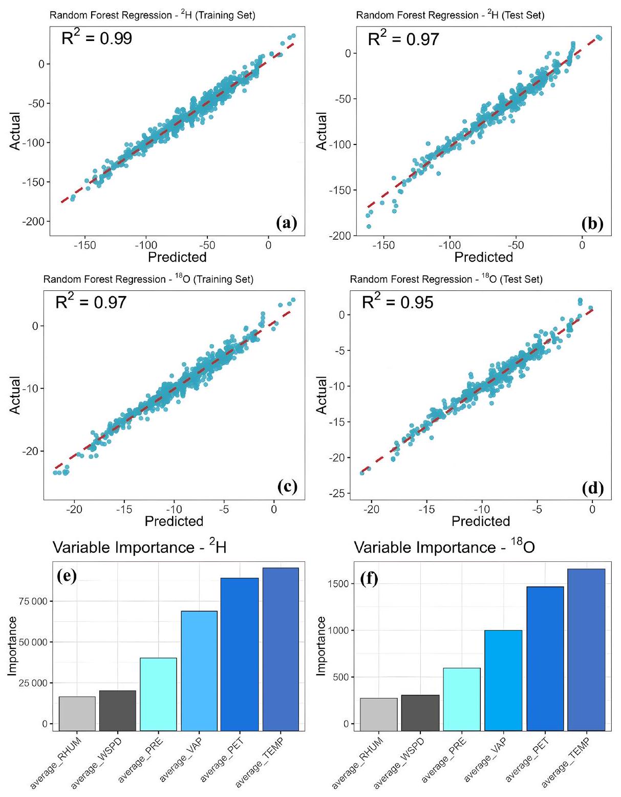
3.4 Controlling factors for stable isotopes in surface water

For precipitation stable isotopes, there is a significant “latitude effect” and “continent effect” (Dansgaard, 1964); this pattern of variation is also observed in the stable isotopes of surface water, characterised by a gradual decrease in stable isotope values from low to high latitudes and from coastal to arid inland areas. However, in low-latitude regions near the Equator, where surface water is primarily recharged by precipitation and where climatic factors do not vary significantly with latitude, there is no significant spatial variation in the stable isotopes of surface water.
Additionally, numerous studies have demonstrated that the stable isotope composition of surface water is predominantly influenced by climatic factors (Araguás-Araguás et al., 1998; Dansgaard, 1964; Wang et al., 2017). To assess the importance of various meteorological variables in relation to the stable isotopes of surface water globally, we employed an RF model. The RF regression analysis fitted to the stable isotopes of surface water indicated a strong model fit for both the training and test sets. This suggests that variables such as temperature, precipitation, potential evapotranspiration, vapour pressure, wind speed and relative humidity possess significant explanatory power for the stable isotopes of surface water (Fig. 7). The validation results of the RF model
demonstrate excellent prediction performance for both and , with showing better prediction accuracy than , as indicated by the smaller RMSE and MAE values (Table S1). Among the six meteorological factors considered, temperature exerts the strongest influence on surface water stable isotopes. Potential evapotranspiration also exhibits a strong controlling effect, suggesting that temperature and evapotranspiration are the primary factors governing changes in global surface water stable isotopes. Additionally, relative humidity and wind speed demonstrate high explanatory power for variations in surface water stable isotopes. Previous studies have indicated that wind speed and relative humidity significantly influence evaporation from waterbodies (Gallart et al., 2024; Skrzypek et al., 2015), which can subsequently impact surface water stable isotopes. While vapour pressure and precipitation offer weaker explanations for variations in surface water stable isotopes, these factors can largely be attributed to the residence time of surface water and the local hydrological cycle. The residence time of surface water and the characteristics of the local hydrological cycle vary significantly across different regions. Large open waterbodies typically have longer residence times and slower hydrological cycles, resulting in a more enriched isotopic composition of surface water (Feng et al., 2016). In contrast, waterbodies with faster hydrological cycles, such as rivers, may exhibit different isotopic compositions (Ala-aho et al., 2018). However, interpreting these patterns on a large scale requires further investigation and validation.
Simultaneously, for lakes, reservoirs and other large open waterbodies, the controls on surface water stable isotopes can be more complex. Studies have demonstrated that global stable isotope variations in lakes result from the combined effects of solar radiation, evapotranspiration, catchment area size and other factors (Vystavna et al., 2021). These controls vary across different regions, contributing to diverse stable isotopic compositions in surface waters worldwide. For instance, in arid zones, solar radiation primarily controls stable isotopic variations in lakes, whereas, in temperate climatic zones, evaporation and transpiration play a dominant role. Consequently, the controlling factors for surface water stable isotopes vary significantly across different regions. However, overarching patterns suggest that geographic and meteorological factors collectively govern the stable isotopic changes in surface water within a region.

3.5 Challenges and limitations in the construction of surface water isotope datasets and future research directions

At present, due to the limitations of sampling techniques and methods, there may be significant differences in sampling methods and frequencies across various geological environments and hydrogeological conditions. These differences can affect the comparison and analysis of the data. Constructing a comprehensive isotope dataset for surface water requires
Figure 6. Relationship between and in different climatic zones.
careful consideration of spatial and temporal coverage to ensure data accuracy and comparability (Ankor et al., 2019). However, due to cost, labour and equipment constraints, as well as the harsh natural conditions in sampling areas, it is challenging to achieve continuous observation of different watersheds over long time frames. This limitation results in some incompleteness of the data in terms of spatial and temporal scales (Penna et al., 2014). In addition, the accuracy of the current stable isotope data has yet to be harmonised due to issues such as sample preservation, analytical techniques and instrumental accuracy. These challenges may lead to problems in the comparability and overall reliability of the data.
In the future, establishing harmonised standards for data collection, storage and sharing will be essential for creating a global isotope database for surface water. Additionally, integrating data from different sources, times and locations will be necessary to develop a more comprehensive global isotope database for surface water (Chen et al., 2024; Zhu et al., 2022). With advances in artificial intelligence, there is a growing trend towards integrating isotope data with hydrologic modelling (Gierz et al., 2017; Nelson et al., 2021). This integration promises to enhance our understanding of hydrologic processes and to improve water resource management practices. Furthermore, it facilitates improvements in the spatial and temporal coverage of data, offering more robust insights into water dynamics and interactions within ecosystems. Meanwhile, within the context of global change,
the study of climate change and of isotopes is becoming increasingly integrated and interdisciplinary. In the longer term, there is potential to develop a comprehensive understanding and application of isotope datasets for surface water. This development will rely on integrating expertise from disciplines such as geology, hydrology, meteorology and others, fostering a holistic approach to studying and managing water resources in a changing climate.

4 Data availability

The Global Stable Isotope Dataset for Surface Water is now publicly available, and the data can be found at https://doi.org/10.17632/fs7rwp7fpr. 2 (Zhu, 2024).

5 Conclusion

The Global Stable Isotope Dataset for Surface Water provides crucial information for advancing our understanding of the water cycle, climate change and environmental monitoring. In this study, we established a global surface water stable isotope dataset by combining measured data and reference data from existing station data. This approach enriched the dataset and enabled comprehensive analysis across different regions and climatic zones. The results reveal pronounced spatial and temporal variations in the stable isotope composition of global surface water, with significant differences being observed in the isotopic composition of surface
Figure 7. The relationship between and and meteorological factors was analysed using the RF model. (a) regression results of the training set. (b) regression results of the test set. (c) regression results of the training set. (d) regression results of the test set. (e) Effect of meteorological factors on . (f) Effect of meteorological factors on .
water across different climates. The variations in global surface water isotopes are influenced by a combination of geographic and meteorological factors, with temperature and evapotranspiration being among the climatic factors exhibiting strong explanatory power for the isotopic composition of surface water. Observations of stable isotopes in global surface water play a crucial role in enhancing our understanding of the global water cycle, climate change and water resource management. They provide essential data support for interdisciplinary research, helping to uncover connections between hydrological processes, climate variability and environmental changes worldwide. Although we have enriched
this dataset as much as possible, there are still regions with sparse data, such as Siberia and eastern Europe. In the future, efforts should focus on strengthening observations in these challenging areas where data availability is limited. Improving the resolution of global surface water stable isotope data can be achieved by integrating interdisciplinary approaches and leveraging artificial intelligence methods. This approach will help fill data gaps, enhance accuracy and provide more comprehensive insights into global water dynamics and environmental changes.
Supplement. The supplement related to this article is available online at https://doi.org/10.5194/essd-17-2135-2025-supplement.
Author contributions. GZ and RL: writing (original draft preparation). SL and LC: data curation. XQ: writing (reviewing and editing). GM and YW: methodology. WL: investigation. ZZ, JY and YG: software.
Competing interests. The contact author has declared that none of the authors has any competing interests.
Disclaimer. Publisher’s note: Copernicus Publications remains neutral with regard to jurisdictional claims made in the text, published maps, institutional affiliations, or any other geographical representation in this paper. While Copernicus Publications makes every effort to include appropriate place names, the final responsibility lies with the authors.
Acknowledgements. We thank the editor, Yuqiang Zhang, and the two anonymous reviewers for providing a list of critical and very valuable comments that helped to improve the paper. The authors would like to thank Annie L. Putman and Gabriel J. Bowen for their contributions to the wiDB database and the International Atomic Energy Agency for their outstanding contributions with respect to the GNIR dataset. Finally, the authors thank all of the researchers and institutions that provided data.
Financial support. This study was supported by the National Natural Science Foundation of China (grant nos. 42371040 and 41971036), the Key Natural Science Foundation of Gansu Province (grant no. 23JRRA698), the Key Research and Development Program of Gansu Province (grant no. 22YF7NA122), the Gansu Provincial Basic Research Innovation Group Project (grant no. 22JR5RA129), the Western Light Young Scholars Program of the Chinese Academy of Sciences, the Northwest Normal University Major Key Project Cultivation Program (grant no. NWNU-LKZD-202302), and the Northwest Normal University Oasis Scientific Research Achievement Breakthrough Action Plan Project (grant no. NWNU-LZKX-202303).
Review statement. This paper was edited by Yuqiang Zhang and reviewed by two anonymous referees.

References

Aggarwal, P. K., Alduchov, O., Araguás Araguás, L., Dogramaci, S., Katzlberger, G., Kriz, K., Kulkarni, K. M., Kurttas, T., Newman, B. D., and Purcher, A.: New capabilities for studies using isotopes in the water cycle, EoS Transactions, 88, 537-538, https://doi.org/10.1029/2007EO490002, 2007.
Aggarwal, P. K., Alduchov, O. A., Froehlich, K. O., AraguasAraguas, L. J., Sturchio, N. C., and Kurita, N.: Stable isotopes in global precipitation: A unified interpretation based on atmospheric moisture residence time, Geophys. Res. Lett., 39, 2012GL051937, https://doi.org/10.1029/2012GL051937, 2012.
Ala-aho, P., Soulsby, C., Pokrovsky, O. S., Kirpotin, S. N., Karlsson, J., Serikova, S., Manasypov, R., Lim, A., Krickov, I., Kolesnichenko, L. G., Laudon, H., and Tetzlaff, D.: Permafrost and lakes control river isotope composition across a boreal Arctic transect in the Western Siberian lowlands, Environ. Res. Lett., 13, 034028, https://doi.org/10.1088/1748-9326/aaa4fe, 2018.
Ankor, M. J., Tyler, J. J., and Hughes, C. E.: Development of an autonomous, monthly and daily, rainfall sampler for isotope research, J. Hydrol., 575, 31-41, https://doi.org/10.1016/j.jhydrol.2019.04.074, 2019.
Araguás-Araguás, L., Froehlich, K., and Rozanski, K.: Stable isotope composition of precipitation over southeast Asia, J. Geophys. Res., 103, 28721-28742, https://doi.org/10.1029/98JD02582, 1998.
Autio, A., Ala-Aho, P., Rossi, P. M., Ronkanen, A.-K., Aurela, M., Lohila, A., Korpelainen, P., Kumpula, T., Klöve, B., and Marttila, H.: Groundwater exfiltration pattern determination in the sub-arctic catchment using thermal imaging, stable water isotopes and fully-integrated groundwater-surface water modelling, J. Hydrol., 626, 130342, https://doi.org/10.1016/j.jhydrol.2023.130342, 2023.
Bershaw, J., Saylor, J. E., Garzione, C. N., Leier, A., and Sundell, K. E.: Stable isotope variations ( and ) in modern waters across the Andean Plateau, Geochim. Cosmochim. Ac., 194, 310-324, https://doi.org/10.1016/j.gca.2016.08.011, 2016.
Bowen, G. J., Kennedy, C. D., Liu, Z., and Stalker, J.: Water balance model for mean annual hydrogen and oxygen isotope distributions in surface waters of the contiguous United States, J. Geophys. Res., 116, G04011, https://doi.org/10.1029/2010JG001581, 2011.
Bowen, G. J., Cai, Z., Fiorella, R. P., and Putman, A. L.: Isotopes in the Water Cycle: Regional- to Global-Scale Patterns and Applications, Annu. Rev. Earth Planet. Sci., 47, 453-479, https://doi.org/10.1146/annurev-earth-053018-060220, 2019.
Breiman, L.: Random Forests, Mach. Learn., 45, 5-32, https://doi.org/10.1023/A:1010933404324, 2001.
Chahine, M. T.: The hydrological cycle and its influence on climate, Nature, 359, 373-380, https://doi.org/10.1038/359373a0, 1992.
Chen, L., Wang, Q., Zhu, G., Lin, X., Qiu, D., Jiao, Y., Lu, S., Li, R., Meng, G., and Wang, Y.: Dataset of stable isotopes of precipitation in the Eurasian continent, Earth Syst. Sci. Data, 16, 1543-1557, https://doi.org/10.5194/essd-16-1543-2024, 2024.
Chen, Y., Helliker, B. R., Tang, X., Li, F., Zhou, Y., and Song, X.: Stem water cryogenic extraction biases estimation in deuterium isotope composition of plant source water, P. Natl. Acad. Sci. USA, 117, 33345-33350, https://doi.org/10.1073/pnas.2014422117, 2020.
Cooley, S. W., Ryan, J. C., and Smith, L. C.: Human alteration of global surface water storage variability, Nature, 591, 78-81, https://doi.org/10.1038/s41586-021-03262-3, 2021.
Dansgaard, W.: Stable isotopes in precipitation, Tellus, 16, 436468, https://doi.org/10.1111/j.2153-3490.1964.tb00181.x, 1964.
Darling, W. G.: Hydrological factors in the interpretation of stable isotopic proxy data present and past: a Eu-
ropean perspective, Quaternary Sci. Rev., 23, 743-770, https://doi.org/10.1016/j.quascirev.2003.06.016, 2004.
Dudley, B. D., Yang, J., Shankar, U., and Graham, S. L.: A method for predicting hydrogen and oxygen isotope distributions across a region’s river network using reach-scale environmental attributes, Hydrol. Earth Syst. Sci., 26, 4933-4951, https://doi.org/10.5194/hess-26-4933-2022, 2022.
Dutton, A., Wilkinson, B. H., Welker, J. M., Bowen, G. J., and Lohmann, K. C.: Spatial distribution and seasonal variation in of modern precipitation and river water across the conterminous USA, Hydrol. Process., 19, 4121-4146, https://doi.org/10.1002/hyp.5876, 2005.
Feng, X., Lauder, A. M., Posmentier, E. S., Kopec, B. G., and Virginia, R. A.: Evaporation and transport of water isotopologues from Greenland lakes: The lake size effect, Quaternary Sci. Rev., 131, 302-315, https://doi.org/10.1016/j.quascirev.2015.07.029, 2016.
Gallart, F., González-Fuentes, S., and Llorens, P.: Technical note: Isotopic fractionation of evaporating waters: effect of sub-daily atmospheric variations and eventual depletion of heavy isotopes, Hydrol. Earth Syst. Sci., 28, 229-239, https://doi.org/10.5194/hess-28-229-2024, 2024.
Gierz, P., Werner, M., and Lohmann, G.: Simulating climate and stable water isotopes during the Last Interglacial using a coupled climate-isotope model, J. Adv. Model. Earth Syst., 9, 2027-2045, https://doi.org/10.1002/2017MS001056, 2017.
Halder, J., Terzer, S., Wassenaar, L. I., Araguás-Araguás, L. J., and Aggarwal, P. K.: The Global Network of Isotopes in Rivers (GNIR): integration of water isotopes in watershed observation and riverine research, Hydrol. Earth Syst. Sci., 19, 3419-3431, https://doi.org/10.5194/hess-19-3419-2015, 2015.
Hu, X., Belle, J. H., Meng, X., Wildani, A., Waller, L. A., Strickland, M. J., and Liu, Y.: Estimating PM 2.5 Concentrations in the Conterminous United States Using the Random Forest Approach, Environ. Sci. Technol., 51, 6936-6944, https://doi.org/10.1021/acs.est.7b01210, 2017.
Immerzeel, W. W., Lutz, A. F., Andrade, M., Bahl, A., Biemans, H., Bolch, T., Hyde, S., Brumby, S., Davies, B. J., Elmore, A. C., Emmer, A., Feng, M., Fernández, A., Haritashya, U., Kargel, J. S., Koppes, M., Kraaijenbrink, P. D. A., Kulkarni, A. V., Mayewski, P. A., Nepal, S., Pacheco, P., Painter, T. H., Pellicciotti, F., Rajaram, H., Rupper, S., Sinisalo, A., Shrestha, A. B., Viviroli, D., Wada, Y., Xiao, C., Yao, T., and Baillie, J. E. M.: Importance and vulnerability of the world’s water towers, Nature, 577, 364-369, https://doi.org/10.1038/s41586-019-1822-y, 2020.
Jameel, Y., Stahl, M., Michael, H., Bostick, B. C., Steckler, M. S., Schlosser, P., Van Geen, A., and Harvey, C.: Shift in groundwater recharge of the Bengal Basin from rainfall to surface water, Commun. Earth Environ., 4, 14, https://doi.org/10.1038/s43247-022-00650-z, 2023.
Joussaume, S., Sadourny, R., and Jouzel, J.: A general circulation model of water isotope cycles in the atmosphere, Nature, 311, 24-29, https://doi.org/10.1038/311024a0, 1984.
Kartal, V.: Machine learning-based streamflow forecasting using CMIP6 scenarios: Assessing performance and improving hydrological projections and climate change, Hydrol. Process., 38, e15204, https://doi.org/10.1002/hyp.15204, 2024.
Kendall, C. and Coplen, T. B.: Distribution of oxygen-18 and deuterium in river waters across the United States, Hydrol. Process., 15, 1363-1393, https://doi.org/10.1002/hyp.217, 2001.
Liu, M., Vecchi, G., Soden, B., Yang, W., and Zhang, B.: Enhanced hydrological cycle increases ocean heat uptake and moderates transient climate change, Nat. Clim. Chang., 11, 848-853, https://doi.org/10.1038/s41558-021-01152-0, 2021.
Mehta, P., Siebert, S., Kummu, M., Deng, Q., Ali, T., Marston, L., Xie, W., and Davis, K. F.: Half of twenty-first century global irrigation expansion has been in water-stressed regions, Nat. Water, 2, 254-261, https://doi.org/10.1038/s44221-024-00206-9, 2024.
Nelson, D. B., Basler, D., and Kahmen, A.: Precipitation isotope time series predictions from machine learning applied in Europe, P. Natl. Acad. Sci. USA, 118, e2024107118, https://doi.org/10.1073/pnas.2024107118, 2021.
Peel, M. C., Finlayson, B. L., and McMahon, T. A.: Updated world map of the Köppen-Geiger climate classification, Hydrol. Earth Syst. Sci., 11, 1633-1644, https://doi.org/10.5194/hess-11-16332007, 2007.
Penna, D., Ahmad, M., Birks, S. J., Bouchaou, L., Brenčič, M., Butt, S., Holko, L., Jeelani, G., Martínez, D. E., Melikadze, G., Shanley, J. B., Sokratov, S. A., Stadnyk, T., Sugimoto, A., and Vreča, P.: A new method of snowmelt sampling for water stable isotopes, Hydrol. Process., 28, 5637-5644, https://doi.org/10.1002/hyp.10273, 2014.
Penna, D., Hopp, L., Scandellari, F., Allen, S. T., Benettin, P., Beyer, M., Geris, J., Klaus, J., Marshall, J. D., Schwendenmann, L., Volkmann, T. H. M., von Freyberg, J., Amin, A., Ceperley, N., Engel, M., Frentress, J., Giambastiani, Y., McDonnell, J. J., Zuecco, G., Llorens, P., Siegwolf, R. T. W., Dawson, T. E., and Kirchner, J. W.: Ideas and perspectives: Tracing terrestrial ecosystem water fluxes using hydrogen and oxygen stable isotopes – challenges and opportunities from an interdisciplinary perspective, Biogeosciences, 15, 6399-6415, https://doi.org/10.5194/bg-15-6399-2018, 2018.
Reckerth, A., Stichler, W., Schmidt, A., and Stumpp, C.: Long-term data set analysis of stable isotopic composition in German rivers, J. Hydrol., 552, 718-731, https://doi.org/10.1016/j.jhydrol.2017.07.022, 2017.
Satoh, Y., Yoshimura, K., Pokhrel, Y., Kim, H., Shiogama, H., Yokohata, T., Hanasaki, N., Wada, Y., Burek, P., Byers, E., Schmied, H. M., Gerten, D., Ostberg, S., Gosling, S. N., Boulange, J. E. S., and Oki, T.: The timing of unprecedented hydrological drought under climate change, Nat. Commun., 13, 3287, https://doi.org/10.1038/s41467-022-30729-2, 2022.
Schulte, P., Van Geldern, R., Freitag, H., Karim, A., Négrel, P., Petelet-Giraud, E., Probst, A., Probst, J.-L., Telmer, K., Veizer, J., and Barth, J. A. C.: Applications of stable water and carbon isotopes in watershed research: Weathering, carbon cycling, and water balances, Earth-Sci. Rev., 109, 20-31, https://doi.org/10.1016/j.earscirev.2011.07.003, 2011.
Skrzypek, G., Mydłowski, A., Dogramaci, S., Hedley, P., Gibson, J. J., and Grierson, P. F.: Estimation of evaporative loss based on the stable isotope composition of water using Hydrocalculator, J. Hydrol., 523, 781-789, https://doi.org/10.1016/j.jhydrol.2015.02.010, 2015.
Sprenger, M., Leistert, H., Gimbel, K., and Weiler, M.: Illuminating hydrological processes at the soil-vegetation-atmosphere in-
terface with water stable isotopes, Rev. Geophys., 54, 674-704, https://doi.org/10.1002/2015RG000515, 2016.
Vystavna, Y., Harjung, A., Monteiro, L. R., Matiatos, I., and Wassenaar, L. I.: Stable isotopes in global lakes integrate catchment and climatic controls on evaporation, Nat. Commun., 12, 7224, https://doi.org/10.1038/s41467-021-27569-x, 2021.
Wang, S., Zhang, M., Crawford, J., Hughes, C. E., Du, M., and Liu, X.: The effect of moisture source and synoptic conditions on precipitation isotopes in arid central Asia, J. Geophys. Res.-Atmos., 122, 2667-2682, https://doi.org/10.1002/2015JD024626, 2017.
Zhu, G.: Global Stable Isotope Dataset for Surface Water, V2, Mendeley Data [data set], https://doi.org/10.17632/fs7rwp7fpr.2, 2024.
Zhu, G., Liu, Y., Shi, P., Jia, W., Zhou, J., Liu, Y., Ma, X., Pan, H., Zhang, Y., Zhang, Z., Sun, Z., Yong, L., and Zhao, K.: Stable water isotope monitoring network of different water bodies in Shiyang River basin, a typical arid river in China, Earth Syst. Sci. Data, 14, 3773-3789, https://doi.org/10.5194/essd-14-37732022, 2022.